Menu
  • About us
    • Company
    • Team
    • Career
    • References
    • Partners
    • Contact
  • Products
    • Earth Observation metadata enhancer
    • Temperaturdaten
    • LST-Data Client
    • Trainings
  • Services
    • actinia – geoprocessing in the cloud
    • Geospatial and EO data analysis
    • CORONA spy satellite data
    • maps.mundialis
    • Web Map Services
    • GIS Development
    • Open Source GIS
  • Markets
    • Remote Sensing for Agriculture
    • Satellite Images for Forest and Land Cover Restoration
    • Glass fibre route planning – FTTH
    • Copernicus and Sentinel
  • News & Blog
    • News
    • Blog
    • Satellite image of the month
  • English English
  • Deutsch Deutsch

Satellite image of the month – March – Madrid (Spain)


9. March 2021 | Category blog,

Madrid – Spain, recorded by the Sentinel-2A satellite on January 11, 2021

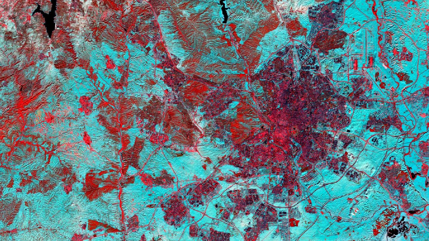
The satellite image of the month March shows Madrid with snow. The image was created from different bands based on Sentinel-2A data of the EU Copernicus Programme and provides a spatial resolution of 20 m. After downloading the scene, an atmospheric correction was carried out using free software, and a color composite was calculated using three different spectral bands. For this false color composite, the three channels short-wave infrared, visible and near infrared, and visible red were used. Ground and cities appear in shades of red and pink, water in dark blue to black, and snow and ice in dynamic blue.

The city of Madrid is located in the right half of the image. With about 3.3 million inhabitants, it is the second largest city in the European Union after Berlin. The Madrid metropolitan region (with suburbs) has a population of about 7 million inhabitants and is thus ranging among the largest metropolitan areas in Europe.

In January 2021, the storm Filomena caused an immense snow chaos in Spain’s capital. The satellite image shows the extent of snow (in turquoise) on January 11, 2021, Monday after the snowy weekend. With temperatures reaching double digits below zero, it snowed for more than 30 hours, and the snow cover was more than 60 cm thick in some places.
Due to the snow, air, rail and bus services were temporarily suspended. Although many highways and country roads were closed, more than 1,500 people were stuck in their cars for many hours. In the satellite image, the cleared roads are easily detectable as red bands in the snow. Also at the airport in the northeast of the city cleared operational areas (runways, etc.) and snow-covered surroundings are clearly distinguishable.
In addition to the traffic chaos, the high snow cover also caused school closings and stalling of food supplies to supermarkets. On the other hand, many Madrid residents enjoyed the white weekend, engaging in boisterous snowball fights or taking to the streets on skis and sleds.

Storm Filomena also brought snowfall and storm to numerous other provinces in Spain. In the province of León, about 400 km north of Madrid, an all-time low of -35.8 degrees Celsius was recorded, the lowest temperature ever recorded in Spain. Although relatively cold winters are not uncommon in Madrid due to its continental location about 650 m above sea level, comparable temperatures and snowfalls have only been experienced in 1984 and 1971.

Contains modified Copernicus Sentinel data (2021)/ESA – created by mundialis

More satellite images can be found here: https://maps.mundialis.de

Comments are currently closed.

Follow Us

Contact

mundialis GmbH & Co. KG
Kölnstrasse 99
53111 Bonn

Phone: +49 (0)228 / 387 580 80
Fax: +49 (0)228 / 962 899 57

E-Mail: info [at] mundialis [dot] de

Latest News

  • FOSS4G 2022 in “La Bella” – Greetings from Florence!

    Thursday July 14th, 2022
  • VALE project successfully completed

    Tuesday June 21st, 2022
  • Taking part in ESA’s Earth Observation conference / A look back on the LPS 2022

    Friday June 10th, 2022
  • Presenting at the ESA Living Planet Symposium 2022

    Tuesday April 19th, 2022
  • Le Kollektiv – Meeting in Bonn

    Monday March 28th, 2022
View all News

Blog

  • Satellite image of the month – August – Florence (Italy) 1. August 2022
    Florence – Italy, recorded by the Sentinel-2A satellite on March ...
  • Satellite image of the month – July – Delta du Saloum National Park (Republic of Senegal) 1. July 2022
    Delta du Saloum National Park – Republic of Senegal, recorded ...
  • Satellite image of the month – June – Prague (Czech Republic) 1. June 2022
    Prague – Czech Republic, recorded by the Sentinel-2A satellite on ...
View all Blog Posts

Copyright © 2015-2021 mundialis GmbH & Co. KG

Imprint Privacy

Theme created by PWT. Powered by WordPress.org