
Durrat Al Bahrain – Kingdom of Bahrain, recorded by the Sentinel-2A satellite on October 16, 2021
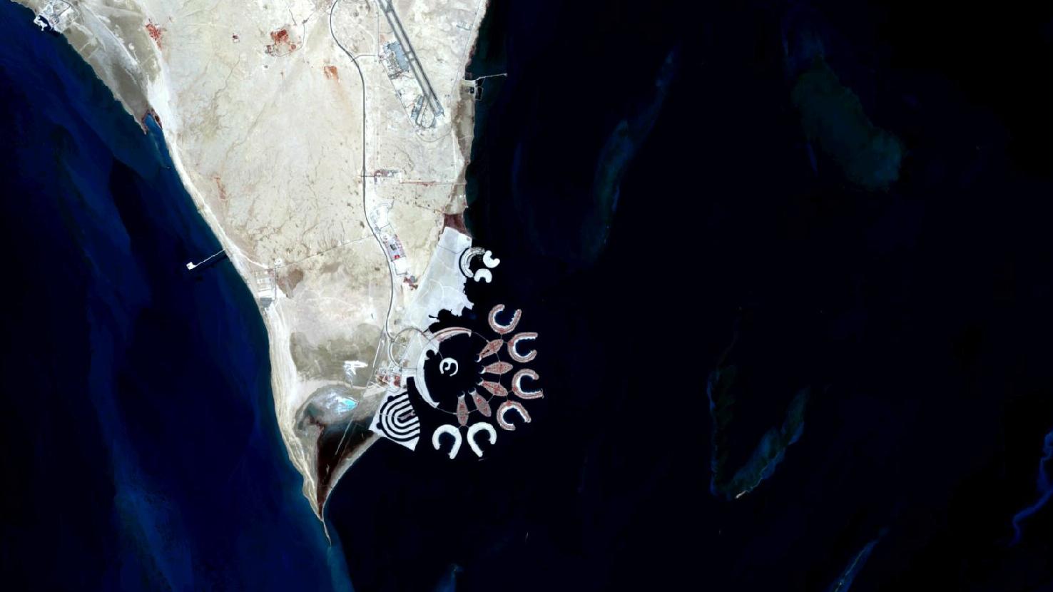
The satellite image of the month October shows the artificial island Durrat Al Bahrain in the Kingdom of Bahrain.
The Sentinel-2A image shows a color-infrared composite created from different bands, with a spatial resolution of 10 meters. Sentinel-2 data from the EU Copernicus program are multispectral satellite images that are freely available. After downloading the scene, an atmospheric correction was performed with free software. The color composite was calculated with the bands 8 (near infrared), 4 (red) and 3 (green). In the chosen color-infrared composite, vegetation appears in different shades of red and soil in shades of brown and green. Urban regions are depicted in brownish-grey, water in bright blue tones.
Bahrain is an island state in the Persian Gulf. It is situated between the states of Saudi Arabia in the west and Qatar in the east and consists of a total of 33 islands. The country is mostly covered by sand dunes and sandy areas. In the picture, this is represented by the predominantly yellow-brown coloring, which is only very occasionally interspersed with reddish or gray structures. At the top right of the landmass, an airbase can be seen.
The area of Bahrain is about 750 square kilometers which is a bit smaller than the city area of Hamburg. The area also includes various artificial islands. One such artificial island group is Durrat Al Bahrain, translated as “Pearl of Bahrain”, at the southeastern tip of the Kingdom of Bahrain, about 40 kilometers south of its capital Al Manama.
First plans for the land reclamation were made in 2002 and construction began in 2004. The archipelago consists of 15 larger artificial islands with a total area of 20 square kilometers. The most striking of the islands are the five fish-shaped islands and the six horseshoe-shaped atolls. In addition, there are two crescent-shaped islands and two more small islands.
In 2021, all five of the fish-shaped islands and the four northernmost of the horseshoe-shaped islands were covered by built-up. The built-up areas can be recognized very well by the reddish-gray textures on the islands. The buildings on the islands include luxury villas and hotels, restaurants and stores as well as mosques, parks and sports facilities. There is also a large marina that spans several islands. Artificially created beaches are located within the tail fins of the fish islands and on the inside of the atolls. The islands are a “gated community” that is guarded. The villas and infrastructure are mainly used on weekends. Even some members of the royal family own one or more villas here.
Contains modified Copernicus Sentinel data (2021)/ESA – created by mundialis
More satellite images can be found here: https://maps.mundialis.de