
The objective of HERMOSA is to quantify restoration activities and to create credibility through transparency. To be more precise, the quantification relates
- to the location and area size,
- the activities being carried out,
- the partners involved, the time needed for the project implementation,
- the amount of money spent,
- the amount of restoration and conservation achieved,
- and numerous other details that can be measured.
Since ecosystem restoration is an essential component of the fight against climate change and an incredible amount of money is involved, many stakeholders have a vested interest in knowing what is happening when, where, how and by whom. This transparency leads to trust and credibility of the various stakeholders involved and is paramount for funding to be allotted to the projects. To reach our objective, we need to combine latest scientific state-of-the-art, and latest advances in information technology.
One essential functionality in this context is the detection of change. Due to the global scope of the challenge ground based cadastral services to detect and monitor this change are out of the question. To realise the automated classification of remotely sensed optical data for large areas, it is essential to create a mosaic from individual satellite images as input for the classification algorithm. This data has to be corrected for atmospheric influences and clouds need to be detected. The classification is achieved by assigning land use classes from known points to the remaining areas in the image. Since it is highly impractical to manually create these training data for large and diverse areas, a set of rules is defined to automatically generate potential training areas for a range of classes. We use machine learning to classify the image mosaic in its entirety.
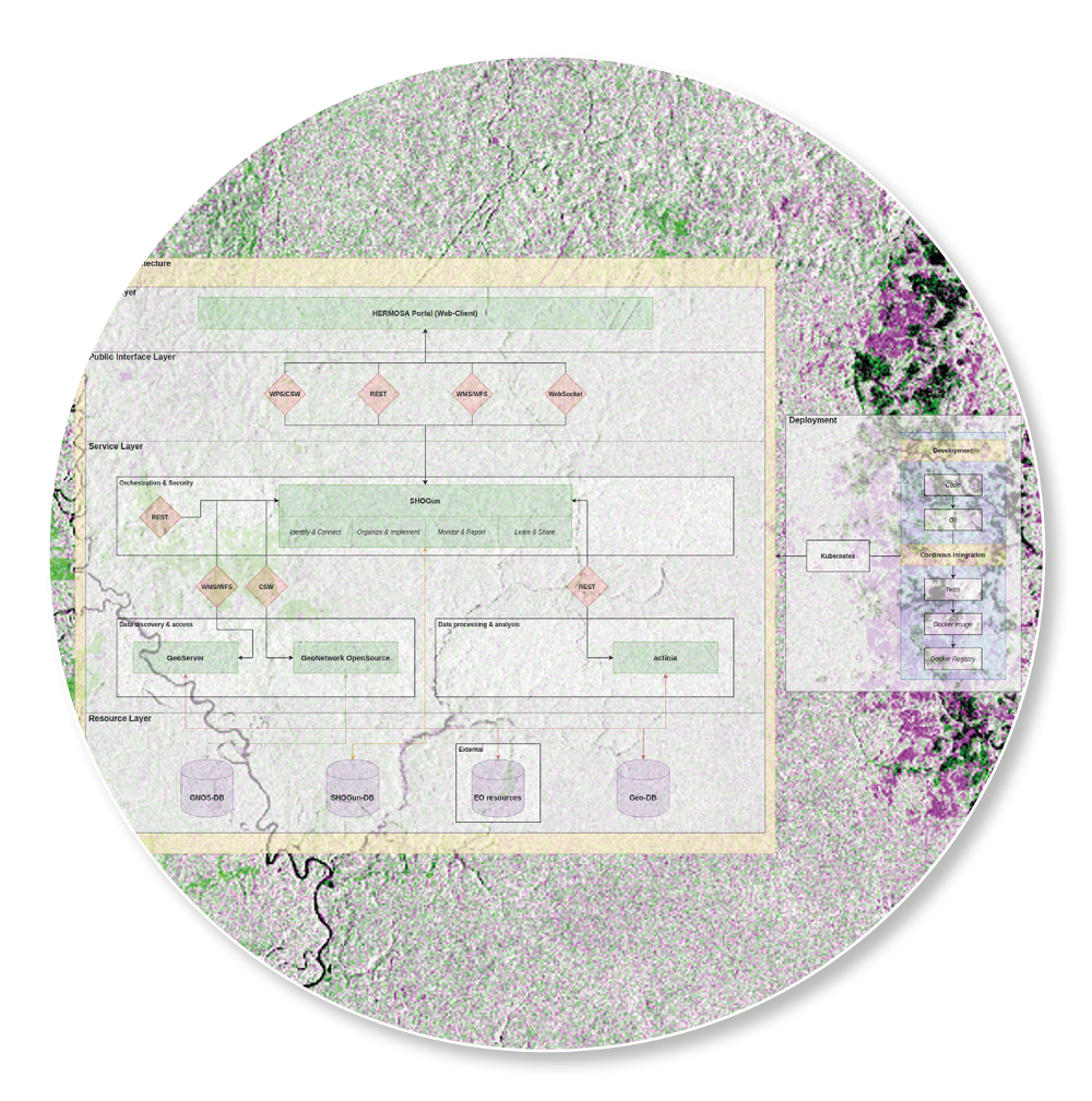
 The large amount of input data and classification steps require a processing environment suitable for big data that can be easily customised and automated. The cloud-based geoprocessing platform actinia meets these requirements. At its core lies the open source geoinformation system GRASS GIS which offers an abundant range of geoprocessing modules. This vast functionality can be easily extended by writing custom GRASS GIS add-ons which in turn can be made accessible to actinia. Users can define custom processing chains consisting of many individual steps that are fed to actinia via a REST API. Intermediate results can be stored in ephemeral or persistent GRASS GIS databases.
The HERMOSA team has been working on the implementation of these methods and algorithms also in the context of other projects, with results having been scientifically reviewed. The science behind the methods is quite robust and has been tried and tested, however we are continuously integrating new scientific insights and new possibilities due to advances in technology. We welcome any input on how we can further improve our services. We are striving to enhance the modelling and analysis capabilities of the system every day to tackle the most challenging task of our times.
Please contact sales@hermosa.earth to get started today!
reposted from: https://hermosa.mundialis.de/news/bulletin-kw-20/