Menu
  • About us
    • Company
    • Team
    • Career
    • References
    • Partners
    • Contact
  • Products
    • Earth Observation metadata enhancer
    • Temperaturdaten
    • LST-Data Client
    • Trainings
  • Services
    • actinia – geoprocessing in the cloud
    • Geospatial and EO data analysis
    • CORONA spy satellite data
    • maps.mundialis
    • Web Map Services
    • GIS Development
    • Open Source GIS
  • Markets
    • Remote Sensing for Agriculture
    • Satellite Images for Forest and Land Cover Restoration
    • Glass fibre route planning – FTTH
    • Copernicus and Sentinel
  • News & Blog
    • News
    • Blog
    • Satellite image of the month
  • English English
  • Deutsch Deutsch

CORONA spy satellite data: the 1960s in high resolution!


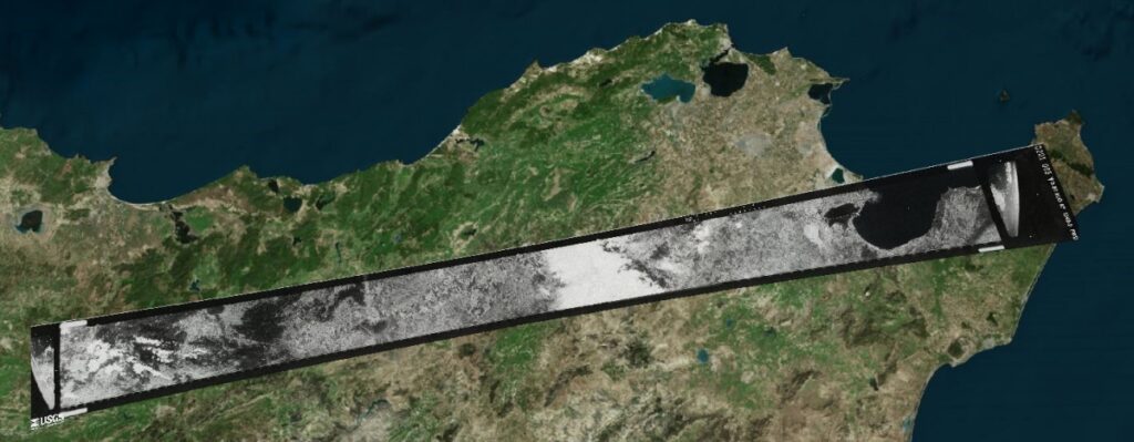
CORONA is the code name for the first optical spy satellite mission of the United States (1960-1972). The goal of the mission was to produce high-resolution analog photos of most of the Earth’s surface, especially of political hot spots and military locations (Wikipedia). Due to the regular recordings, large areas could be continuously monitored and evaluated for the Department of Defense. Until 1995, the more than 800,000 photos remained secret and were then made publicly available by the US Geological Survey on the order of President Bill Clinton. The high-resolution CORONA photos (2 m to 60 cm pixel resolution) are available as scans for a fee from the USGS and represent a unique source of information for science, archaeology and other disciplines.

Since the camera systems of the CORONA satellites have a special panoramic distortion, common linear methods cannot be used for the orthorectification of the scans.
mundialis has developed an innovative technology to rectify these unreferenced scans of CORONA photos to current map references. This photogrammetric solution models the CORONA camera mathematically and thus enables a precise referencing of the CORONA data.
CORONA spy satellite data

Source: Bing (https://www.bing.com/maps/)
OpenStreetMap


(see also: respective position in OpenStreetMap of Tunis, Tunisia)

mundialis has successfully processed the following spy satellite data, among others:

  • CORONA (keyhole KH4A + KH4B):
    • KH-4A: Aug. 1963 – Oct. 1969
    • KH-4B: Sept. 1967 – May 1972
  • LANYARD (Keyhole KH-6)
    • KH-6: Jul. 1963 – Aug. 1963
  • GAMBIT (Keyhole KH-7):
    • KH-7: July 1963 – June 1967


Contact us for further details!

Follow Us

Contact

mundialis GmbH & Co. KG
Kölnstrasse 99
53111 Bonn

Phone: +49 (0)228 / 387 580 80
Fax: +49 (0)228 / 962 899 57

E-Mail: info [at] mundialis [dot] de

Latest News

  • FOSSGIS 2023 – this time in Berlin again!

    Tuesday February 21st, 2023
  • ++ Eine neue Heimat für Actinia ++

    Tuesday January 24th, 2023
  • Positive towards the future – Management changes at mundialis

    Tuesday October 4th, 2022
  • Recap of FOSS4G 2022 in Florence

    Friday September 16th, 2022
  • FOSS4G 2022 in “La Bella” – Greetings from Florence!

    Thursday July 14th, 2022
View all News

Blog

  • Satellite image of the month – March – Berlin (Germany) 7. March 2023
    Berlin – Germany, recorded by the Sentinel-2B satellite on September ...
  • Satellite image of the month – February – Amazon Rainforest (Brazil and Bolivia) 7. February 2023
    Amazon Rainforest – Brazil and Bolivia, recorded by the Sentinel-2A ...
  • Satellite image of the month – January – Yalu River (People’s Republic of China and Democratic People’s Republic of Korea) 2. January 2023
    Yalu River – People’s Republic of China and Democratic People’s ...
View all Blog Posts

Copyright © 2015-2023 mundialis GmbH & Co. KG

Imprint Privacy

Theme created by PWT. Powered by WordPress.org