
Berry Islands – Bahamas, recorded by the Sentinel-2A satellite on August 1st, 2025
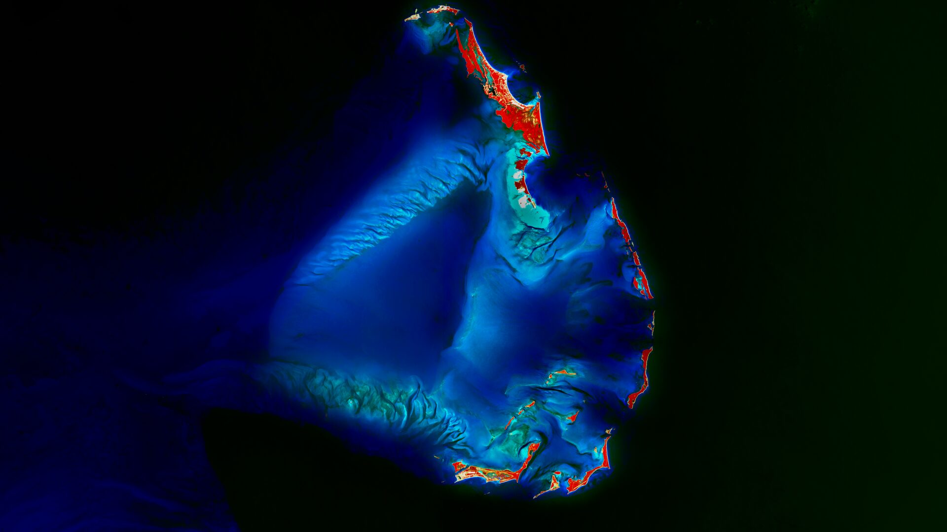
Our Satellite Image of the Month shows the Berry Islands, an island chain belonging to the Bahamas. The chain is located in the northwestern part of the country, specifically north of New Providence Island, which is home to the capital, Nassau.
The image is based on Sentinel-2 data from the EU Copernicus programme. Sentinel-2 data are freely available multispectral satellite images. After downloading, several scenes were merged using open-source software, atmospherically corrected, and a color composite was then created using bands 8 (near infrared), 4 (red) and 3 (green). A sharpening method also allows spectral bands with an original spatial resolution of 20 metres to be enhanced to 10-metre resolution.
Structure of the Image
The chosen false-color infrared rendering is particularly well suited to detecting vegetation. Vegetation appears in various shades of red, which in this case allows a clear distinction between the sea surface and the islands, which are mostly densely vegetated. Shallow water with sandbanks is shown in turquoise tones. The deeper the water, the darker blue it appears; the deep ocean is visualized in black.
About the Island Group
The Berry Islands are an island group and district of the Bahamas and consist of around 30 cays and many smaller islets, with a total land area of approximately 31 km². The term “cay” denotes a small, flat island made up of sand and coral deposits. The word (kayo) originally derives from the Taíno, an indigenous people who lived in the region before colonisation. The two largest and best-known islands are Great Harbour Cay (in the north of the group) and Chub Cay (in the south). Most of the roughly 800 inhabitants live on these two islands.
The island group lies on the Bahama Bank, a flat carbonate platform made of limestone that formed over long periods through the deposition of calcareous skeletal remains from corals and other organisms. The resulting calcareous sandy soils are unsuitable for agricultural use. Terrestrial vegetation is therefore largely limited to various species of palms. In contrast, there are diverse coral species as well as seagrass and mangrove habitats, which provide important habitat for many fish species and shellfish. The Berry Islands are also known as the “Fish Bowl of the Bahamas” and are popular for recreational activities such as snorkeling and diving; they are also much loved by sport fishers. In the southern Berry Islands, the South Berry Islands Marine Reserve has existed since 2008 to protect the region’s marine flora and fauna.
The Berry Islands, compared to other island groups in the Bahamas, have so far been relatively undeveloped in terms of tourism. There are only a few hotel resorts, while a large portion of the buildings consist of private residences. However, cruise tourism is increasing. In recent years, several cruise companies have purchased individual cays; for example, Great Stirrup Cay belongs to Norwegian Cruise Line, while Little Stirrup Cay is used by Royal Caribbean as “CocoCay.” Both islands are located in the northern part of the island chain and are regularly visited.
Great Stirrup Cay is operated as an exclusive private island, and the company plans extensive expansions for next year, including additional docks as well as new recreational and water facilities. The associated construction activities cause local changes to the marine and coastal environmental conditions, such as through dredging, land reclamation, or the removal of coastal vegetation. Such interventions can harm corals, seagrass beds, and mangrove stands. In the long term, this weakens the islands’ natural resilience to hurricanes and sea-level rise, reduces fish stocks, and exacerbates the ecological vulnerability of an already sensitive ecosystem.
In the context of climate change, the Berry Islands, like many other small island states, face major challenges. They are highly vulnerable to hurricanes, which regularly destroy coastlines, increase erosion and force temporary evacuations of communities. They are also particularly exposed to sea-level rise, which exacerbates flooding, salt intrusion into groundwater and the loss of valuable land. At the same time, coral reefs and other marine habitats are coming under increasing stress from bleaching, disease, overuse and local disturbances, which also harms fisheries. These ecological pressures affect small, import-dependent communities that can barely absorb economic shocks, making them particularly socially and economically vulnerable in the long term.
A Different View of the Region
The following animation helps to understand the geographical location of the image. It shows the location of the satellite image various scales. The map visualisations were created using the terrestris OpenStreetMap Premium service.
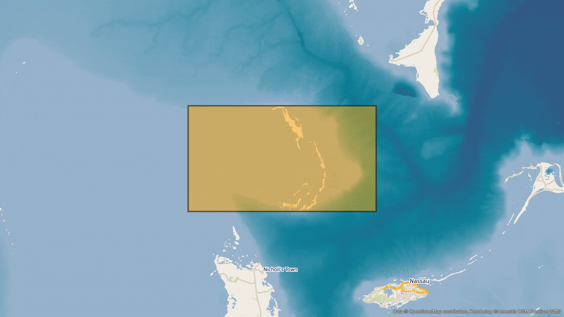
Contains modified Copernicus Sentinel data (2025)/ESA – created by mundialis
Satellite images for your wall are available at https://art-from-space.de