
Khartoum – Sudan, recorded by the Sentinel-2A satellite on May 17, 2021
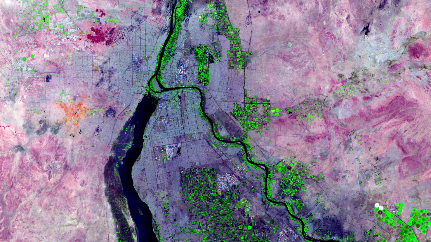
Our satellite image of the month April shows the city of Khartoum and its surroundings.
The image shows a color composite created from Sentinel-2 data from the EU Copernicus program. Sentinel-2 data are multispectral satellite images which are free to obtain. After downloading, the scene was atmospherically corrected using free software. The color composite was calculated using the three bands 11 (shortwave infrared), 8A (visible and near infrared), and 4 (visible red). This combination allows a spatial resolution of 20 meters. This false-color composite is particularly suitable for vegetation analysis. Healthy vegetation appears in vibrant shades of green and is very easy to distinguish from soil, which is colored in a spectrum from light pink to bright pink. Clouds appear in white, water is shown in dark blue to black, and urban areas are colored from light gray to purple.
Khartoum is the capital of the Republic of the Sudan and is located at an altitude of about 380 meters in the state of Khartoum State. Approximately 2.7 million people live in the city core, and 5.3 million live in the Khartoum metropolitan region, making Khartoum the largest metropolitan region in Sudan.
The city lies at the confluence of the Blue Nile and the White Nile. The White Nile flows from Lake Victoria in the south. In the picture it is the left of the two river branches coming into the picture from below. The Blue Nile comes from the southeast from Lake Tana in Ethiopia. At their confluence, the two rivers enclose Tuti Island. This ca. 8 square kilometer crescent-shaped island can be seen in the picture right above the wide end of the White Nile. The name Khartoum comes from the Arabic al-Khartūm, which translates as “the elephant’s trunk” and refers to the course of the river at Tuti Island. After the confluence, the Nile continues to flow north toward Egypt and the Mediterranean Sea.
Divided by the Nile, Khartoum, together with the cities of Omdurman and Khartoum Bahri (also Khartoum North), is part of a tripartite city connected by several bridges. Khartoum itself lies to the south between the White Nile and the Blue Nile. Omdurman is located west of the Nile and Khartoum Bahri lies east of the Nile, right above the bend of the Blue Nile. With these cities, the three largest cities in Sudan are located in the state of Khartoum State. The agglomeration has a population of about 8.4 million, making it one of the largest agglomerations in Africa.
Also noticeable on the satellite image are the bright green fields, especially along the Blue Nile and the Nile River. The strong green color indicates healthy vegetation. Because the climate in Sudan is dry, agriculture is only possible on the fertile banks of the Nile and in irrigation projects. A large irrigation project to increase agricultural production (esp. cotton, later wheat) is the Gezira Scheme, which already started in the early 20th century. It uses a canal system where, due to the soil sloping away from the river, the water from the Blue Nile runs naturally through the irrigation canals to the fields in the Gezira Plain (south of Khartoum, between the two Nile tributaries). In the image, the northern end of this large agricultural plain is visible with the last typical fields, which are rather small and squat. The Nile and irrigation along the Nile were already a topic in this satellite image of the month about the Aswan Dam.
Contains modified Copernicus Sentinel data (2021)/ESA – created by mundialis
More satellite images can be found here: https://maps.mundialis.de