
Amazon Rainforest – Brazil and Bolivia, recorded by the Sentinel-2A satellite on September 20, 2022
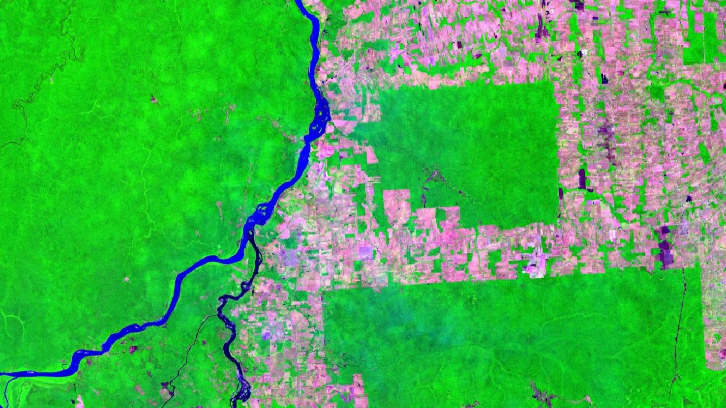
Our satellite image of the month February shows part of the South American rainforest in the Brazilian-Bolivian border region.
The image shows a color composite based on Sentinel-2 data from the Copernicus program. Sentinel-2 data are multispectral satellite images which are free to obtain. After downloading the scene, an atmospheric correction was carried out and a false-color composite was computed using the three spectral bands shortwave infrared (11), visible and near-infrared (8A), and visible red (4). These bands provide a spatial resolution of 20 meters. The focus of this composite type is on vegetation analysis. Healthy vegetation appears in bright shades of green and can be very easily distinguished from soil, which is colored in a spectrum from pink (e.g., harvested fields) to bright pink (e.g., deforested rainforest). Clouds appear in white, water in dark shades of blue to black, and cities are colored light gray to pink.
The depicted region is located on the border between Brazil to the east and Bolivia to the west, just north of the villages of Giajará-Mirim in the state of Rondônia, in northwestern Brazil, and Guayaramerín in the department of Beni in the lowlands, in the northeast of the landlocked South American state of Bolivia. In the image section, the border between the two states is formed by the two rivers Rio Mamoré and Rio Madeira. The Rio Mamoré flows from the central bottom of the image to the center of the image, where it joins the Rio Madre de Dios, which comes from the lower left corner of the picture. Together they form the river Rio Madeira, which continues Northeast and is a direct tributary of the Amazon River.
When comparing the two sides to the left and right of this natural state border, the difference in color is striking. In the area shown, a large part of the rainforest has been deforested on the Brazilian side (right part of the image), whereas there is less to no deforestation on the Bolivian side (left part of the image). The deforested areas can be identified easily by the bright pink coloring and the linear structures at the edge of the clearing areas. The dense rainforest, on the other hand, is colored in a bright neon green in this color composite.
Brazil has seen a sharp increase in deforestation in recent years. Last September alone, 1,455 square kilometers of the Amazon rainforest were deforested, which is roughly twice the area of the city of Hamburg. In all of 2018, the total deforestation was 1.35 million hectares. In addition to many negative ecological consequences, deforestation also entails social consequences. Not only in the fight against climate change, but also in terms of loss of biodiversity and species conservation, as well as in the preservation of habitats of the indigenous population, the developments are dramatic. With his election as Brazil’s new president in October 2022, politician Lula da Silva promised to fight for the end of the destruction of the Brazilian rainforest. In a previous term in office, he achieved an 80% reduction in deforestation.
In the fight against deforestation, satellite images make an essential contribution, e.g. in monitoring areas. For these purposes, mundialis, together with its sister company terrestris, has developed the HERMOSA platform on behalf of the European Space Agency (ESA). The platform is currently being further used in the context of ESMERALDA.
Contains modified Copernicus Sentinel data (2022)/ESA – created by mundialis
More satellite images can be found here: https://maps.mundialis.de