Menu
  • About us
    • Company
    • Team
    • Career
    • References
    • Partners
    • Contact
  • Products
    • Earth Observation metadata enhancer
    • Temperaturdaten
    • LST-Data Client
    • Trainings
  • Services
    • actinia – geoprocessing in the cloud
    • Geospatial and EO data analysis
    • CORONA spy satellite data
    • maps.mundialis
    • Web Map Services
    • GIS Development
    • Open Source GIS
  • Markets
    • Remote Sensing for Agriculture
    • Satellite Images for Forest and Land Cover Restoration
    • Glass fibre route planning – FTTH
    • Copernicus and Sentinel
  • News & Blog
    • News
    • Blog
    • Satellite image of the month
  • English English
  • Deutsch Deutsch

Satellite image of the month – July – Delta du Saloum National Park (Republic of Senegal)


1. July 2022 | Category blog,

Delta du Saloum National Park – Republic of Senegal, recorded by the Sentinel-2B satellite on March 18, 2022
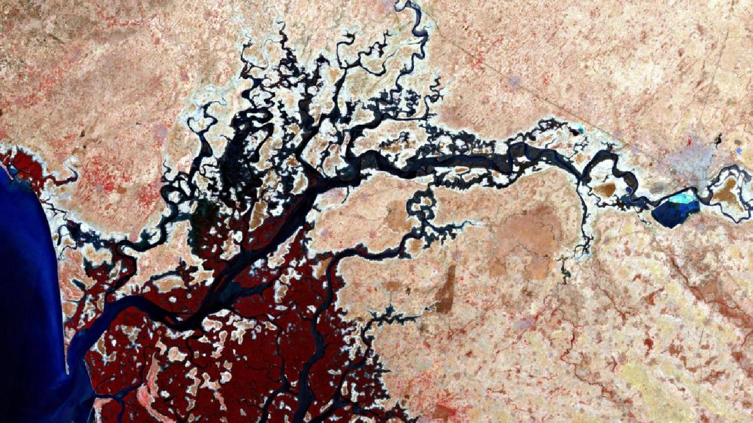
The satellite image of the month July shows the Delta du Saloum National Park in the Republic of Senegal.

The image shown is based on multispectral data from the Sentinel-2B satellite of the EU Copernicus program. These data are freely available. Subsequent to the download, an atmospheric correction and the calculation of a false color composite (bands: 8 (NIR), 4 (Red) und 3 (Yellow)) was performed using free software. The selected color infrared representation is particularly well suited for the detection of vegetation. Vegetation appears in different shades of red, older vegetation in green, soil in shades of brown and green, urban regions in blue-gray, clouds, snow and ice are light turquoise or white. The spatial resolution of the image is 10 m.

The Delta du Saloum National Park (French: Parc National du Delta du Saloum) was established in 1976 and is located on the Atlantic coast of Senegal, situated within the river delta of the two rivers Saloum (coming from the east) and Sine (coming from the north). Its boundaries enclose an area of 76,000 hectares. In 1980, the area was classified as a Biosphere Reserve and since 2011 it has also been considered a UNSECO World Heritage Site, as the entire Saloum Delta, covering an area of 145,811 hectares, has been classified as a World Heritage Site.

The park is home to one of the most important mangrove populations in western Africa. Mangrove forests are characterized by shrubs and trees of various plant families adapted to the conditions of brackish river deltas and ocean coasts. In the image the mangrove vegetation can be identified by the strong red colour along the arms of the river. Besides coral reefs and tropical rainforests, mangroves are the most productive ecosystems on earth. They provide a habitat for a wide variety of species, both below and above water. Animal species present are marine mammals, such as dolphins, antelopes, such as crown duiker and bushbuck, as well as warthogs and spotted hyenas. Primates, such as the hussar monkey and the West African stubby monkey, are also native to the National Park.

People living in the “paradise of birds” often earn their living as crab and mussel fishermen.

Contains modified Copernicus Sentinel data (2022)/ESA – created by mundialis

More satellite images can be found here: https://maps.mundialis.de

Comments are currently closed.

Follow Us

Contact

mundialis GmbH & Co. KG
Kölnstrasse 99
53111 Bonn

Phone: +49 (0)228 / 387 580 80
Fax: +49 (0)228 / 962 899 57

E-Mail: info [at] mundialis [dot] de

Latest News

  • FOSSGIS 2023 – this time in Berlin again!

    Tuesday February 21st, 2023
  • ++ Eine neue Heimat für Actinia ++

    Tuesday January 24th, 2023
  • Positive towards the future – Management changes at mundialis

    Tuesday October 4th, 2022
  • Recap of FOSS4G 2022 in Florence

    Friday September 16th, 2022
  • FOSS4G 2022 in “La Bella” – Greetings from Florence!

    Thursday July 14th, 2022
View all News

Blog

  • Satellite image of the month – March – Berlin (Germany) 7. March 2023
    Berlin – Germany, recorded by the Sentinel-2B satellite on September ...
  • Satellite image of the month – February – Amazon Rainforest (Brazil and Bolivia) 7. February 2023
    Amazon Rainforest – Brazil and Bolivia, recorded by the Sentinel-2A ...
  • Satellite image of the month – January – Yalu River (People’s Republic of China and Democratic People’s Republic of Korea) 2. January 2023
    Yalu River – People’s Republic of China and Democratic People’s ...
View all Blog Posts

Copyright © 2015-2023 mundialis GmbH & Co. KG

Imprint Privacy

Theme created by PWT. Powered by WordPress.org