
Eleuthera – The Bahamas, recorded by the Sentinel-2B satellite on January 17, 2023
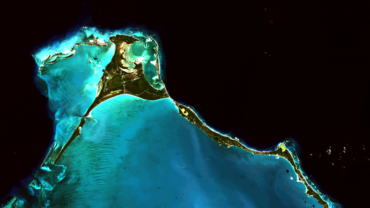
Our satellite image of the month May shows the northern end of Eleuthera, an island of The Bahamas.
The image is based on freely available multispectral Sentinel-2 data from the Copernicus program. After the download, the satellite scene was atmospherically corrected using free software. Hence, a color composition was calculated from different bands. For the “natural color” composition shown here, the bands 4 (red), 3 (green) and 2 (blue) were used, giving a spatial resolution of 10 meters. By using the three bands of visible light, the color of the satellite image corresponds to the normal color perception of the human eye. Vegetation is green, water is blue, soil is yellowish brown, roads and buildings are grey and clouds are white.
Covering an area of 484 square kilometers, Eleuthera is one of the larger islands of the Bahamas. It has a narrow elongated shape, about 180 kilometers long and, in places, less than 1 kilometer wide. The island is located about 80 kilometers east of the capital, Nassau.
The Bahamas are an island state stretching from the southeast coast of the United States, along the northeast coast of Cuba, to the northwest coast of the Turks and Caicos Islands. The Bahamas consist of about 700 islands and about 2,400 coral reefs called cays. The island ridges are very flat, mostly not more than 15 – 20 meters high. The highest elevation is Mount Alvernia at 64 meters, located on Cat Island. The islands of the Bahamas lie on the Bahama Banks, a group of limestone platforms that are up to 4,500 meters thick. The waters of the Bahama Banks are very shallow, usually no deeper than 25 meters. At the edge of the Bahama Banks there are steep slopes and deep ocean begins. Due to the different coloring of the water, the difference is easy to see on the satellite image. While the shallow water with its underlying flat, white sandy beach appears light blue to turquoise, the deep ocean is colored dark blue to black.
This phenomenon can be observed in a particularly impressive way at the Glass Window Bridge on the island of Eleuthera. The Glass Window Bridge is a rock formation and bridge that separates the Atlantic Ocean on the eastern side from the shallow Sound below the bridge and to the west of the island. From the bridge you can see the strong contrast between the dark blue, rough Atlantic and the calm turquoise waters. The Glass Window Bridge is located at Eleuthera’s narrowest point, almost in the center of the picture, just north-west of the greenish pond in the center of the picture.
Also visible in the image is the road running along the narrow ridge of land, with houses and settlements visible along it as bright dots. The North Eleuthera Airport is also located on the slightly wider land area in the north, recognisable by the wider, straight structure of the runway, which is almost horizontal in the image. Another striking feature in the picture are the structures in the turquoise water along the ridge on the left side of the image. These are submerged sand ripples and „dunes“ that can be created by currents.
Fun fact: Eleuthera is also known for the good quality of its pineapples, and an annual pineapple festival is held in Gregory Town, located southeast of the Glass Window Bridge.
Contains modified Copernicus Sentinel data (2023)/ESA – created by mundialis
More satellite images can be found here: https://maps.mundialis.de