
Peloponnese – Greece, recorded by the Sentinel-2B satellite on August 01, 2021
The satellite image of the month October shows the southern part of the Peloponnese peninsula in Greece.
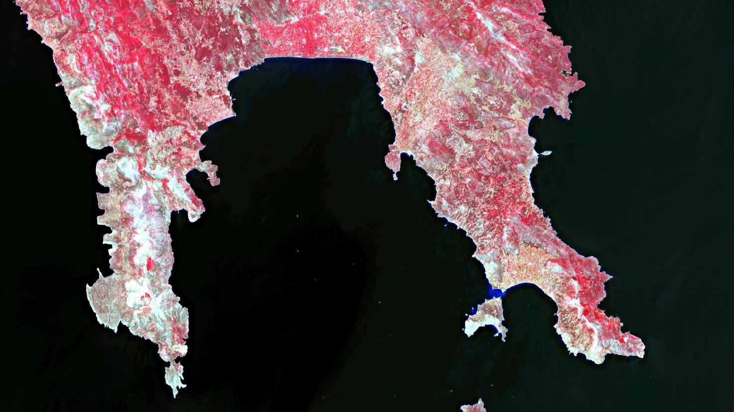
The image is based on Sentinel-2B data from the EU Copernicus Programme. Sentinel-2 data are freely available multispectral satellite images. After the download, the scene was atmospherically corrected using free software. Then a color composite was calculated by using bands 3 (green), 4 (red) and 8 (near infrared). The resulting color infrared composite is particularly well suited for visualizing vegetation. Vegetation appears in different shades of red, older vegetation in green. Soil is depicted in shades of brown and green, urban regions in blue-grey, clouds, snow and ice in light turquoise or white.
The Peloponnese is a peninsula in the south of mainland Greece. At its southern end, it splits into four smaller peninsulas facing south. In the picture, you can see the two “fingers” in the middle. The Mani (left) and Cape Malea (right) both pertain to the region of Laconia. The Laconian Gulf is situated between the two peninsulas.
The region, like the entire Peloponnese, is characterized by the contrast between rugged, inaccessible mountains and fertile, densely populated valleys as well as flat land by the sea.
In the upper center of the picture you can see the lowlands south of Sparta with many small agricultural plots. The river Evrotas can also be seen as a yellowish band in this part of the image. The river is one of the main rivers of the Peloponnese. It comes from the north and drains into the Laconian Gulf.
The right headland in the picture is Cape Malea. To distinguish the actual cape in the south from the entire peninsula, the peninsula is sometimes referred to as “Epidavros Limira”, after the most prominent ancient city located on it. To the west of the peninsula lies the island of Elafonisos which measures about 19 square kilometers in size. It is known for its long, light-coloured, sandy beaches.
On the left side of the picture can be seen the middle finger of the Peloponnese, the Mani. It begins south of the city of Kalamata (not in the picture) and from there extends about 80 kilometers to the south. The southern tip of the peninsula is formed by Cape Ténaro, which is the southernmost point of the Peloponnese. The cape lies even farther to the south than Tunis in Africa and, after Tarifa in Spain, is the second southernmost mainland point in Europe.
The interior of Mani is characterized by the Taygetos Mountains and its foothills, which reach up to 2400 meters. The border between the wooded area (in the north) and the sparse maquis (in the south) is represented by the sparser red coloration towards the south. The Mani is known for the olive trees growing south of Kalamata, from whose fruits the world-famous and protected “Kalamata olive oil” is produced. To the west of the peninsula lies the Messenian Gulf. The entire coastline is indented with numerous bays, many of them deeply incised.
At one of these bays, on the west coast of Mani, is located the small fishing village of Agios Nikolaos. It is, seen from top left, located on the fourth larger promontory of land. In the beginning of October, the mundialis team will spend a week for it’s work retreat here, in order to deepen exciting topics and develop new ideas in a relaxed atmosphere. The fantastic landscape and the good Greek food will certainly be enjoyed too.
Contains modified Copernicus Sentinel data (2021)/ESA – created by mundialis
More satellite images can be found here: https://maps.mundialis.de