
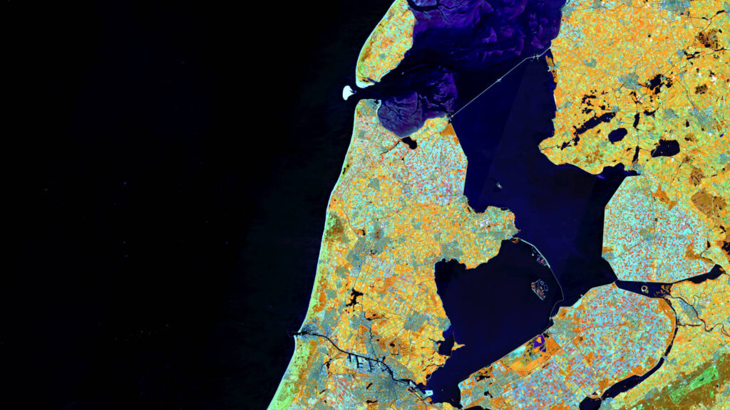
Our satellite image of the month September shows in the center the Dutch province Noord-Holland, which lies as a peninsula between the North Sea and the Ijsselmeer.
The image is based on Sentinel-2 data from the EU Copernicus program. Sentinel-2 data are freely available multispectral satellite images. After downloading, two scenes were merged and atmospheric corrected with free software. Afterwards a color composition was calculated with three different bands.
This band combination is a False color composite useful for discriminating land and water. In this composite the bands 8A (visible and near infrared), 11 (short-wave infrared) and 4 (visible red) were used which provide a spatial resolution of 20 meters. With this composite healthy vegetation appears in orange and older vegetation appears in green. Soil and clouds appear in shades of green as well. Water is painted in blue and shades of purple while ice appears in vibrant magenta.
To the east, the Ijsselmeer borders the province of Noord-Holland. The largest lake in the Netherlands was created in 1932 by the construction of the 29-kilometer-long final dike (Afsluitdijk) at the junction of the former Zuiderzee and the Waddenzee. The dike is 90 meters wide and carries a highway and a bicycle path on its side facing the IJsselmeer. The dike was built primarily to protect the coast. The elimination of the tides in the IJsselmeer subsequently made it easier to dike and drain areas of water. Thus, more than half of the area of Noord-Holland consists of drained areas, called polders. Since polders are often lower than the water level of the adjacent waters, the inland areas must be drained constantly. In the south of the Ijsselmeer, another dike, the Houtribdijk, separates the Ijsselmeer. The dike was built in 1976 and separates the Ijsselmeer from the Markermeer. The West Frisian island of Texel (centre, top of the picture) also belongs to the province of Noord-Holland. It is both the first and the largest of the West Frisian islands in the north of the mainland. Between the island and the mainland the sandbar Noorderhaaks can also be seen.
Both dikes can be seen in the satellite image. In the north, the sandbanks of the Wadden Sea stand out clearly with different shades of purple. The North Sea, on the other hand, is colored in deep black tones, while the Ijssel and Markermeer are shown in dark blue tones. In the south, you can also see the North Sea Canal, which connects the North Sea with the port of Amsterdams and the Markermeer. The capital of the Netherlands can also be seen (centre, bottom of the image), and like other urban areas, it is colored in shades of gray. The rural areas, especially the polders, are mainly used for agriculture. The fields colored in different shades of orange and light blue, depending on how they are cultivated, immediately catch the eye.
At the beginning of September, the mundialis team, together with the sister company terrestris, spends one week for it’s work retreat in Spanbroek in Noord-Holland in order to delve into exciting topics, develop new ideas and enjoy a good time together.
Contains modified Copernicus Sentinel data (2023)/ESA – created by mundialis