On 2nd June 2016, the Sixth GeoDialogue in Bonn took place due to the opening of the GeoSummer (https://geobusiness-region.de). Location of the event was the House of Education in Bonn. Mr Dr. Rainer Neuerbourg, who is responsible for the processing of geo data at the IHK Bonn, led trought the evening. About 40 guests from industry and public administration expected the presentation of Bonn’s GeoSummer by Dr. Ulrich Ziegenhagen, first economic development official. Afterwards, the chairmen of the two international conferences that will be held in Bonn this year introduced their events: Prof. Dr. Klaus Greve talked about the programme of the Earsel taking place in the near future (http:www.earsel.org/symposia/2016-symposium-Bonn/).
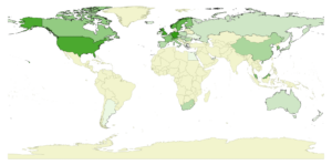
Till Adams, manager of the company mundialis and chairman of the FOSS4G 2016 conference in Bonn, outlined the current status of planing. The map below shows the global distribution of the 410 registered participants of the conference.
Next to 68 registrations from Germany, there are 29 from Great Britain as well as two from New Zealand. Four persons from Australia, six from South Africa and even people from South Corea, Japan, the USA. Canada, China and Malaysia announced their coming. Mr Adams could not resist to point out that only six out of 25 registrations from Bonn are „real ones“: 8 out of 25 people from Bonn are members of the organisation team and 11 persons are from companies to which a FOSS4G is an obligatory date anyway. Moreover, Adams underlined how easy it is for all GIS & Geo people in Bonn to attend a conference without the effort of a long journey as it takes place in their hometown.
Looking at the former venues of the FOSS4G conferences, Bonn can now be found next to the other ten cities that hosted the FOSS4G conference before: „Sydney, Cape Town, Barcelona, Victoria… Bonn. To me -a citizen of Bonn- this sounds really good!“ said Adams.
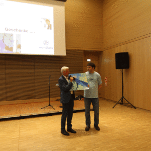
During this presentation, Mr Adams gave a Perspex disc with a Sentinel-2 scene printed on it to Mr Dr. Ziegenhagen, representative of the GeoSummer team, in order to thank them. He noted that satellite images are primarily used as a source for geo data but as they are beautiful they can be perceived as art as well (https://art.mundialis.de/).
The image shows a wrong coloured composition of Argentina based on Sentinel-2 data of the Copernicus programme. Sentinel-2 data are multi-spectral satellite images that are freely disposable. The picture was taken in December 2015. After the download, the scene was atmospheric-corrected and with the help of the bands 12 and 11 (both from the short-wave infrared area) a wrong coloured composition was calculated. In contrast to long wave areas, this combination can penetrate the atmosphere relatively easy. Thereby, water is depicted in black while vegetation is shown in different shades of blue. The picture shows Buenos Aires in Argentina near the Rio de la Plata as well as parts of Uruguay and Argentina. The river Rio Uruguay forms the border of those two countries. The swamp of the Rio Parana can be seen in particularly impressive tones of blue.
Dr. Joachim Post from the UNOOSA/UN-SPIDER in Bonn rounded off the evening with a lecture on „The meaning of the agenda 2030 for the geoinformation.“
(Foto: Monika Rech, rheintext medien)


