
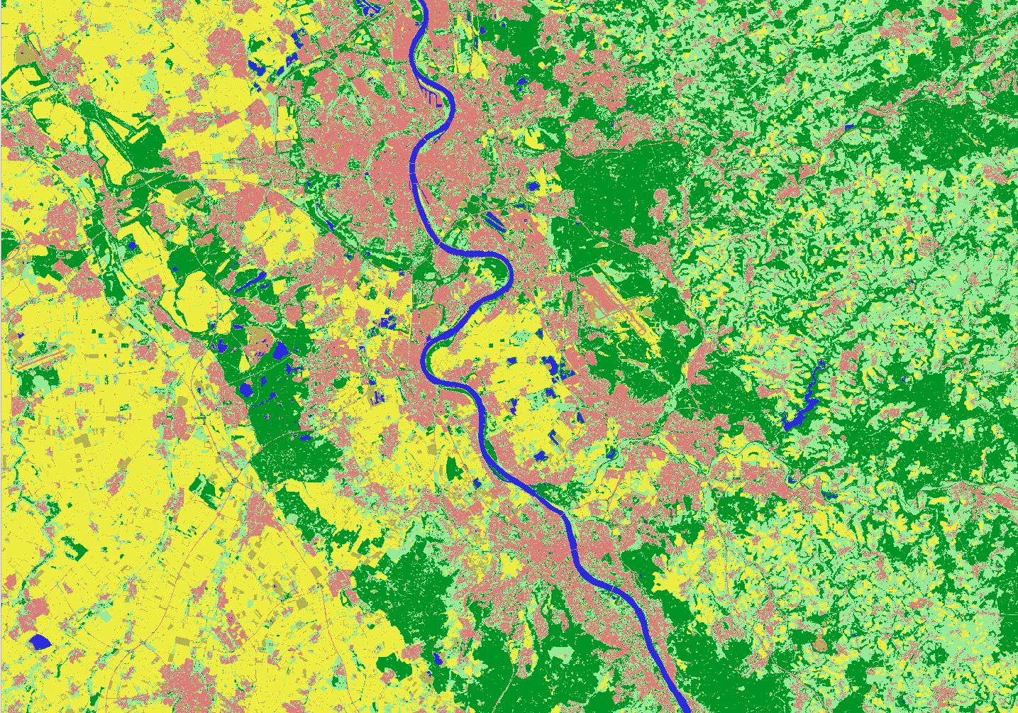
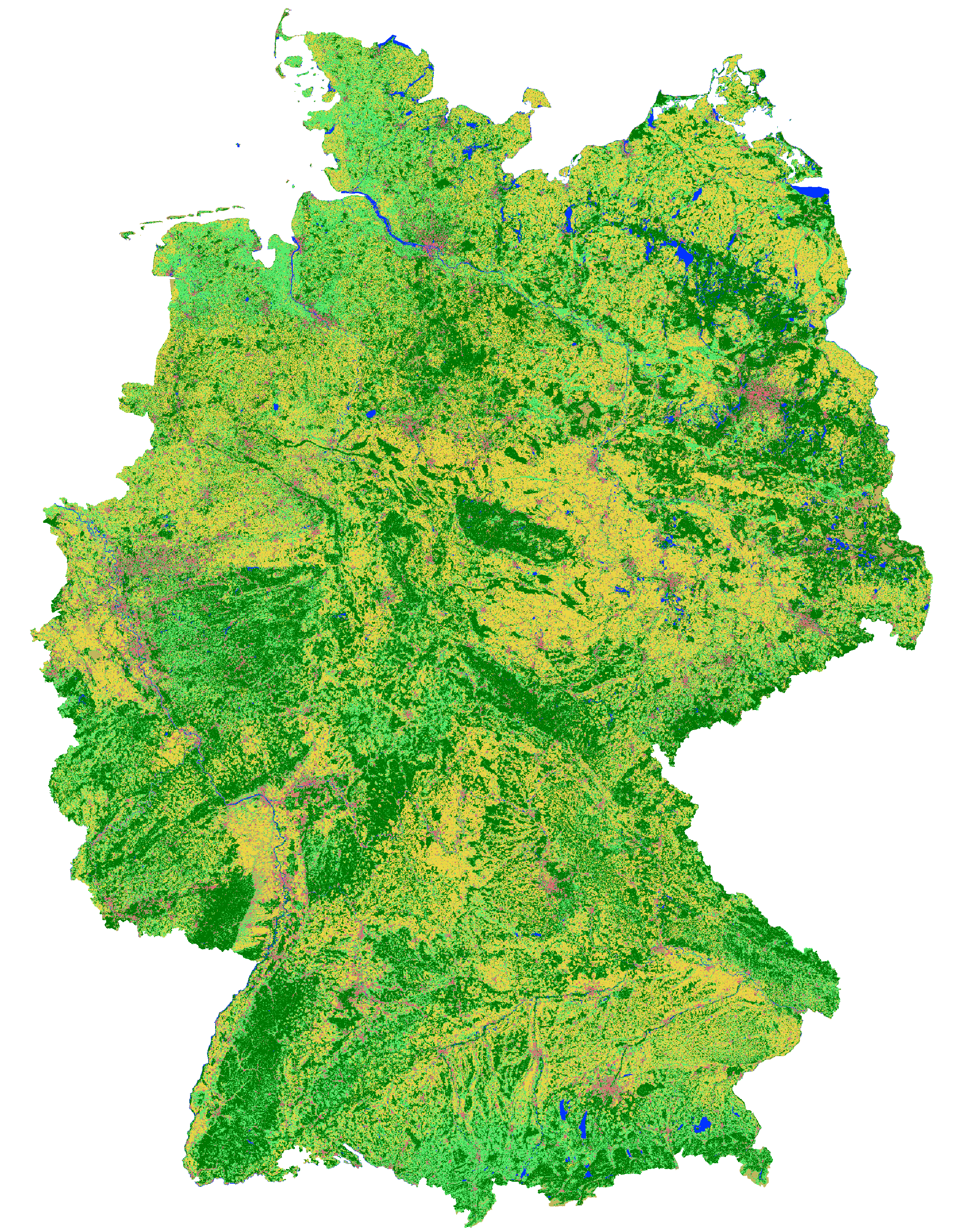
Im Rahmen des Projekts Inwertsetzung von Copernicus-Daten für die Raumbeobachtung (incora, BMVI mFund Förderkennzeichen: 19F2079C) wurde ein automatisches Verfahren entwickelt, um jährliche Landbedeckungsklassifikationen für ganz Deutschland zu erstellen. Die Klassifikationen verfügen über eine räumliche Auflösung von 10m x 10m (Pixelgröße) und bilden die Klassen Bebaute Fläche, Grasland, Wald, Landwirtschaft, Vegetationsloser Boden und Wasser ab. Als Datengrundlage werden mit dem MAJA-Algorithmus atmosphärenkorrigierte Sentinel-2 Daten verwendet, die von EOC Geoservice des Deutschen Zentrums für Luft- und Raumfahrt e.V. (DLR) bereitgestellt wurden. Die für die Klassifikation benötigten Trainingsdaten werden dabei regelbasiert aus Referenzdaten (z.B. OpenStreetMap) sowie den Sentinel-2 Szenen selbst erstellt. Dadurch lässt sich die Prozessierung flexibel auf unterschiedliche Jahre übertragen und vollautomatisch durchführen.
Der Fokus des Projekts incora liegt auf dem Monitoring von Siedlungs- und Verkehrsflächen. Der Vergleich der Deutschlandweiten Klassifikationen für verschiedene Referenzjahre ermöglicht es, klein- sowie großmaßstäbige Veränderungen in der Siedlungsentwicklung abzuleiten. Perspektivisch kann das Verfahren über die gesamte Lebensdauer der Sentinel-2 Satellitenmission angewendet werden, sodass auch langjährige Trends in der Landbedeckungsdynamik Deutschlands sichtbar gemacht werden können.
Die ersten Zwischenergebnisse haben wir hier veröffentlicht
Landbedeckungsklassifizierungskarte von Deutschland 2019 basierend auf Sentinel-2-Daten, 10m Auflösung
- Download: https://data.mundialis.de/geodata/lulc-germany/classification_2019/classification_map_germany_2019_v02.tif
- Metadaten: https://data.mundialis.de/geonetwork/srv/eng/catalog.search#/metadata/36512b46-f3aa-4aa4-8281-7584ec46c813
Landbedeckungsklassifizierungskarte von Deutschland 2016 basierend auf Sentinel-2-Daten, 10m Auflösung
- Download: https://data.mundialis.de/geodata/lulc-germany/classification_2016/classification_map_germany_2016_v0_1.tif
- Metadaten: https://data.mundialis.de/geonetwork/srv/eng/catalog.search#/metadata/db130a09-fc2e-421d-95e2-1575e7c4b45c
Change Detection Karte von Deutschland 2016-2019 basierend auf Sentinel-2 Daten, 10m Auflösung
- Download:
- https://data.mundialis.de/geodata/lulc-germany/change_detection_2016_2019/germany_2016_2019_MAJA_cd_total_v02.tif
- https://data.mundialis.de/geodata/lulc-germany/change_detection_2016_2019/germany_2016_2019_MAJA_cd_water_v02.tif
- https://data.mundialis.de/geodata/lulc-germany/change_detection_2016_2019/germany_2016_2019_MAJA_cd_lowvegetation_v02.tif
- https://data.mundialis.de/geodata/lulc-germany/change_detection_2016_2019/germany_2016_2019_MAJA_cd_forest_v02.tif
- https://data.mundialis.de/geodata/lulc-germany/change_detection_2016_2019/germany_2016_2019_MAJA_cd_builtup_v02.tif
- https://data.mundialis.de/geodata/lulc-germany/change_detection_2016_2019/germany_2016_2019_MAJA_cd_baresoil_v02.tif
- https://data.mundialis.de/geodata/lulc-germany/change_detection_2016_2019/germany_2016_2019_MAJA_cd_agriculture_v02.tif
- Metadaten: https://data.mundialis.de/geonetwork/srv/eng/catalog.search#/metadata/5ef8565b-ea72-4f34-985b-71ab41959230
Datenlizenz (offene Daten):
- Datenlizenz Deutschland – Namensnennung – Version 2.0 (DL-DE->BY-2.0), oder neuer
https://data.mundialis.de/geodata/lulc-germany/classification_2019/LICENSE.html
Ihr Ansprechpartner
Wir stehen Ihnen gerne zur Verfügung:
Guido Riembauer <info@mundialis.de> | Telefon: +49 (0)228 / 387 580 80
Über incora
![]()
Im Rahmen der Nachhaltigkeitsziele ist der sparsame Umgang mit der Ressource Fläche seit vielen Jahren Gegenstand planerischer Interventionen und politischer Maßnahmen der Bundesregierung. Die konfliktreichen Nutzungsansprüche sind benötigen Datengrundlagen für das Monitoring der Siedlungs- und Verkehrsflächenentwicklung. Das incora Projekt nutzt die Datengrundlagen der Copernicus Sentinel-Satelliten, um existierende Indikatoren der Siedlungs- und Verkehrsflächenentwicklung für ein bundesweites Flächenmonitoring zu ergänzen sowie die Qualität und Aussagekraft der bestehenden Kennziffern zu erhöhen. Die Ergebnisse werden in Portalen der Raumbeobachtung öffentlich bereitgestellt.
Das Projekt (Laufzeit: 12/2018 – 11/2021) wird durch das Institut für Landes- und Stadtentwicklungsforschung (ILS) koordiniert, und gemeinsam mit dem Bundesinstitut für Bau-, Stadt- und Raumforschung (BBSR) und der mundialis GmbH & Co. KG durchgeführt.