
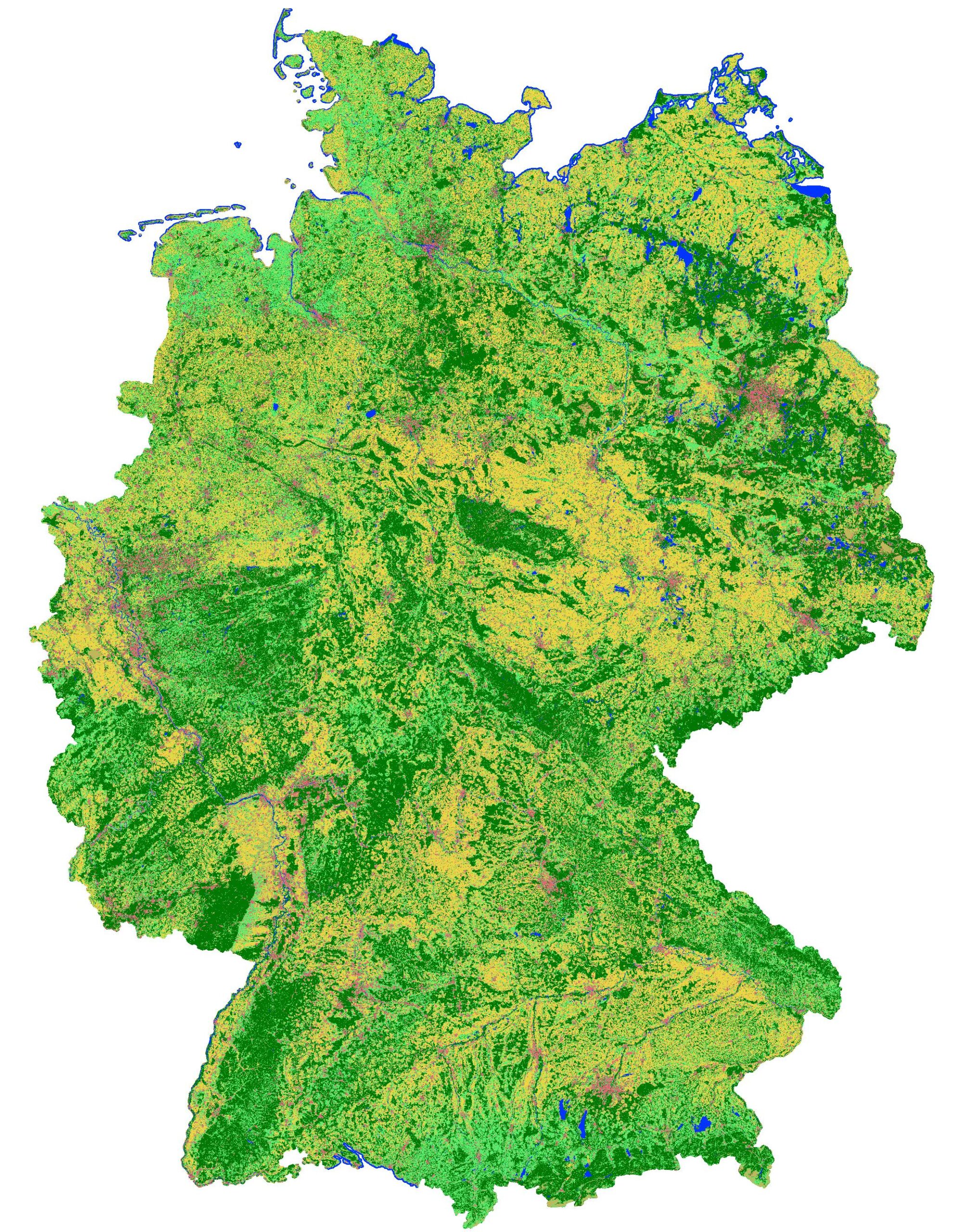
Using the automatic method to create annual land cover classifications for the whole of Germany, developed by mundialis, an up-to-date land cover map for 2020 has now been created (classification maps for 2016 and 2019 are available here). The map includes the classes built-up area, grassland, forest, agriculture, vegetation-free soil and water. The spatial resolution of the map is 10m x 10m (pixel size). The data basis for the classification are atmospherically corrected Sentinel-2 satellite data (with the MAJA algorithm; data provided by EOC Geoservice of the German Aerospace Centre – DLR) as well as training data from reference data (e.g. OpenStreetMap) and the Sentinel-2 scenes themselves.
Thanks to the flexible and fully automated processing, land cover classifications can be generated for different years. In the future, this will also enable the fast and straightforward generation of up-to-date maps in near real-time. Thus, both long-term and current trends of Germany’s land cover can be monitored, supporting decision makers in politics and economy.
We have published the result of the classification for 2020 here:
Landcover classification map of Germany 2020 based on Sentinel-2 data, 10m resolution
- Download: https://data.mundialis.de/geodata/lulc-germany/classification_2020/classification_map_germany_2020_v02.tif
- Metadaten: https://data.mundialis.de/geonetwork/srv/eng/catalog.search#/metadata/9246503f-6adf-460b-a31e-73a649182d07
Data license (open data):
- Data licence Germany – attribution – version 2.0, or later
https://data.mundialis.de/geodata/lulc-germany/classification_2020/LICENSE.html
Method description:
- Riembauer, G., Weinmann, A., Xu, S., Eichfuss, S., Eberz, C., Neteler, M. (2021): Germany-wide Sentinel-2 based Land Cover Classification and Change Detection for Settlement and Infrastructure Monitoring. Submitted to 2021 conference on Big Data from Space (BiDS’2021). https://www.bigdatafromspace2021.org/
- Riembauer, G., Weinmann, A., Tawalika, C., Andreo, V., Delucchi, L., Fagandini, R., Neteler, M. (2021): Sentinel processing in GRASS GIS: A growing toolset for downloading, preprocessing and multitemporal analysis of Copernicus Sentinel data. Submitted to FOSS4G 2021, Buenos Aires, Argentina. https://2021.foss4g.org/, Abstract: https://callforpapers.2021.foss4g.org/foss4g2021/talk/review/8WPFUSU8VDLZ3HXSXBXVSQSMMU9MAEE3
Your contact person
We are at your disposal:
Guido Riembauer <info@mundialis.de> | phone: +49 (0)228 / 387 580 80
About incora
Within the framework of the sustainability goals, the economical use of land as a resource has been the subject of planning interventions and political measures by the German Government for many years. The conflicting demands for land use require data bases for monitoring settlement and transport area development. The incora project uses the data basis of the Copernicus Sentinel satellites to supplement existing indicators of settlement and transport area development for nationwide area monitoring and to increase the quality and significance of existing indicators. The results will be made publicly available in spatial observation portals.
The project incora (duration: 12/2018 – 11/2021, FKZ: 19F20579C) is coordinated by the Institut für Landes- und Stadtentwicklungsforschung (ILS), and will be carried out jointly with the Bundesinstitut für Bau-, Stadt- und Raumforschung (BBSR) and mundialis GmbH & Co. KG.