
Das Europäische Zentrum für mittelfristige Wettervorhersagen (ECMWF) hat ein zweites Summer of Weather Code (ESoWC) Programm ausgerufen, das im September 2019 abgeschlossen wurde. Das Ziel des Programms ist es, die Entwicklung wetterbezogener Open-Source-Software zu fördern. mundialis hat sich mit dem Projekt GIS-based dissolve functionalities using GRASS GIS am diesjährigen Programm beteiligt. Im Rahmen des Projektes waren zwei Aufgaben zu erfüllen, die die Aufrechterhaltung des Europäischen Hochwasserschutzsystems (EFAS) unterstützen:
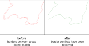
Zunächst wurde eine automatisierte Methode entwickelt, um eine neue EFAS-Partnerregion mit bestehenden Partnerregionen zu kombinieren, wobei beide Gebiete als Polygone vorliegen. Diese Gebiete wurden zu topologisch korrekten neuen Polygonen ohne Überlappungen oder Lücken zusammengeführt. Gemeinsame Grenzen zwischen den Polygonen werden gemäß dem zugehörigen EFAS-Verbreitungszentrum aufgelöst (“dissolve”). Die Herausforderung dabei war, dass diese Polygone aus verschiedenen, inkonsistenten Quellen stammen können.
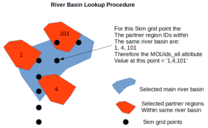
Zweitens mussten Flusseinzugsgebiete und hydrologische Netzpunkte mit den IDs neuer Partnerregionen aktualisiert werden. Ziel war es, Werkzeuge bereitzustellen, die wenig Benutzereingriffe erfordern, und die gesamte Verarbeitung automatisch durchzuführen, sobald die Eingabeparameter eingerichtet sind.
Alle Tools wurden als GRASS GIS Addons mit entsprechenden QGIS Plugins implementiert.
Das Projekt wurde vergangene Woche erfolgreich abgeschlossen, mundialis wurde als eines von 7 herausragenden Projekten prämiert.