Menu
  • About us
    • Company
    • Team
    • Career
    • References
    • Partners
    • Contact
  • Products
    • Imperviousness assessment
    • Tree detection
    • Earth Observation metadata enhancer
    • Monitoring of land use changes
    • Temperaturdaten
    • LST-Data Client
    • Trainings
  • Services
    • actinia – geoprocessing in the cloud
    • Geospatial and EO data analysis
    • CORONA spy satellite data
    • maps.mundialis
    • Web Map Services
    • GIS Development
    • Open Source GIS
  • Markets
    • Remote Sensing for Agriculture
    • Satellite Images for Forest and Land Cover Restoration
    • Glass fibre route planning – FTTH
    • Copernicus and Sentinel
  • News & Blog
    • News
    • Blog
    • Satellite image of the month
  • English English
  • Deutsch Deutsch

HERMOSA Bulletin: Supporting restoration action in Africa


25. May 2021 | Category General

Over the past few weeks we spoke about optical and radar data analyses, VHR data, interoperability and other fancy stuff that HERMOSA is capable of. One of the big questions in this context: Who are the organisations that need this functionality?

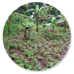
We are proud to introduce Tree Adoption Uganda (TAU), our partner in East Africa. TAU is a youth-centric NGO which engages in landscape restoration activities like planting trees and agroforestry. It aims to build resilience for small holder farmers against the changing climate while economically empowering unemployed young people in Uganda‘s rural communities through education and training, for example by setting up and managing indigenous tree nurseries. When you ask Dr. Charles Batte, the founder of TAU, why his organisation wants to use HERMOSA, you get answers like these:

“We know quite well where some of the degraded lands are located in Uganda, but due to the size of the country we need specialised maps to expand our operation in a meaningful way. This is one of the areas where HERMOSA can support us.”

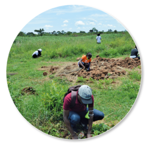
“Probably our biggest challenge is to find money for our projects. We rely on donors to fund the restoration which starts with procuring quality indigenous seedlings. And, at the end of the day, donors want to know what has been achieved with their money. The reporting module of HERMOSA helps us to gain the trust of the donors right from the outset by being able to describe the project in a spatially explicit way, while the monitoring with satellite data can prove what we have done in the field.”

“I collect data and make the maps”, says Stephen Bright Sakwa, an environmental scientist with a passion for conservation and landscape ecology, who works for TAU. “The easy integration of spatial data, created on my desktop computer, into HERMOSA, makes the platform great fun to work with and then everything is on the internet for all to see. On a side note, the analysis of satellite data is also really easy, something that is much more difficult on my desktop and which requires specialised software that is quite expensive to buy.”

In essence, up-to-date data and resulting maps for scaling up, collaboration and reporting capabilities of HERMOSA are essential for TAU. Tree Adoption Uganda and HERMOSA are cooperating closely to develop the platform into something useful for those who are working on the ground. The input from the experts of ecosystem restoration guarantee that
HERMOSA functionality is as easy to use and practical as possible. Maybe also for you, dear reader?

Please contact sales@hermosa.earth to get started today!

reposted from: https://hermosa.mundialis.de/news/bulletin-kw-21/

Comments are currently closed.

Follow Us

Contact

mundialis GmbH & Co. KG
Kölnstrasse 99
53111 Bonn

Phone: +49 (0)228 / 387 580 80
Fax: +49 (0)228 / 962 899 57

E-Mail: info [at] mundialis [dot] de

Latest News

  • Conclusion of the FAIR Project

    Wednesday April 19th, 2023
  • FOSSGIS 2023 – this time in Berlin again!

    Tuesday February 21st, 2023
  • ++ Eine neue Heimat für Actinia ++

    Tuesday January 24th, 2023
  • Positive towards the future – Management changes at mundialis

    Tuesday October 4th, 2022
  • Recap of FOSS4G 2022 in Florence

    Friday September 16th, 2022
View all News

Blog

  • Satellite image of the month – May – Eleuthera (The Bahamas) 2. May 2023
    Eleuthera – The Bahamas, recorded by the Sentinel-2B satellite on ...
  • Satellite image of the month – April – Khartoum (Sudan) 4. April 2023
    Khartoum – Sudan, recorded by the Sentinel-2A satellite on May ...
  • Satellite image of the month – March – Berlin (Germany) 7. March 2023
    Berlin – Germany, recorded by the Sentinel-2B satellite on September ...
View all Blog Posts

Copyright © 2015-2023 mundialis GmbH & Co. KG

Imprint Privacy

Theme created by PWT. Powered by WordPress.org