Menu
  • About us
    • Company
    • Team
    • Career
    • References
    • Partners
    • Contact
  • Products
    • Earth Observation metadata enhancer
    • Temperaturdaten
    • LST-Data Client
    • Trainings
  • Services
    • actinia – geoprocessing in the cloud
    • Geospatial and EO data analysis
    • CORONA spy satellite data
    • maps.mundialis
    • Web Map Services
    • GIS Development
    • Open Source GIS
  • Markets
    • Remote Sensing for Agriculture
    • Satellite Images for Forest and Land Cover Restoration
    • Glass fibre route planning – FTTH
    • Copernicus and Sentinel
  • News & Blog
    • News
    • Blog
    • Satellite image of the month
  • English English
  • Deutsch Deutsch

HERMOSA Bulletin: The evolution of the HERMOSA project


23. March 2021 | Category General

Source: ESA - P. Carril, CC BY-SA IGO 3.0

Source: ESA – P. Carril, CC BY-SA IGO 3.0

In 2016 the European Commission formulated a Space Strategy for Europe which prompted the European Space Agency (ESA) in 2017 to put out a tender requesting concepts to utilize space assets, i.e. data and services from navigation and earth observation satellites, to address food security issues in the context of the Sustainability Development Goal (SDG) 2: Zero Hunger. The company mundialis, founded in 2015 when the Copernicus Programme became operational with the first Sentinel-1 and Sentinel-2 satellites delivering free data at temporal and spatial resolutions never seen before, applied with a concept to identify locations from satellite data suitable for food production. The people behind mundialis combined decades worth of knowledge with regard to remote sensing data analysis and geodata management. ESA liked the proposal and awarded a contract for a period of 6 months to write a concept.

When thinking about food security issues and how these could be helped by data and services from space it very quickly became apparent that food security is embedded into the much larger picture of ecosystems which are influenced by their location on earth and depending on the atmosphere (air), hydrosphere (water), lithosphere (land), biosphere (living organisms) and anthroposphere (societies and their interactions with nature). When addressing hunger (or broader ecosystem restoration) the sheer number of interconnections between these spheres and the involvement of numerous stakeholders called for an integrated portal.

The initial concept struck a chord with ESA so that mundialis was asked to write a well received outline proposal refining the original idea, afterwards a full-proposal was compiled. Granted in July 2019 this proposal laid out the idea of a web-based platform consisting of four modules:

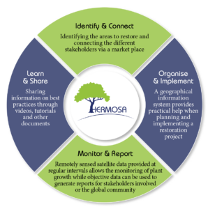
1. Identify & Connect: Matchmaking for stakeholders
2. Organise & Implement: Project implementation support through a web-based geographic information system
3. Monitor & Report: Utilizing Earth Observation data to monitor project progress on the ground
4. Learn & Share: Sharing knowledge and best practices regarding all relevant topics

At the start of the UN Decade on Ecosystem Restoration the platform called Holistic Ecosystem Restoration Monitoring, repOrting, Sharing and mArketplace (HERMOSA, by chance also the Spanish word for ‘beautiful’) is now available for all stakeholders and ready to also support food security issues.

Please contact sales@hermosa.earth today to get started!

reposted from https://hermosa.mundialis.de/news/bulletin-kw-12/

Comments are currently closed.

Follow Us

Contact

mundialis GmbH & Co. KG
Kölnstrasse 99
53111 Bonn

Phone: +49 (0)228 / 387 580 80
Fax: +49 (0)228 / 962 899 57

E-Mail: info [at] mundialis [dot] de

Latest News

  • ++ Eine neue Heimat für Actinia ++

    Tuesday January 24th, 2023
  • Positive towards the future – Management changes at mundialis

    Tuesday October 4th, 2022
  • Recap of FOSS4G 2022 in Florence

    Friday September 16th, 2022
  • FOSS4G 2022 in “La Bella” – Greetings from Florence!

    Thursday July 14th, 2022
  • VALE project successfully completed

    Tuesday June 21st, 2022
View all News

Blog

  • Satellite image of the month – January – Yalu River (People’s Republic of China and Democratic People’s Republic of Korea) 2. January 2023
    Yalu River – People’s Republic of China and Democratic People’s ...
  • Satellite image of the month – December – Super Pit gold mine (Australia) 1. December 2022
    Super Pit gold mine – Australia, recorded by the Sentinel-2A ...
  • Satellite image of the month – November – Kufra-Oases (Libya) 1. November 2022
    Kufra-Oases – Libya, recorded by the Sentinel-2A satellite on March ...
View all Blog Posts

Copyright © 2015-2021 mundialis GmbH & Co. KG

Imprint Privacy

Theme created by PWT. Powered by WordPress.org