Menu
  • About us
    • Company
    • Team
    • Career
    • References
    • Partners
    • Contact
  • Products
    • Earth Observation metadata enhancer
    • Temperaturdaten
    • LST-Data Client
    • Trainings
  • Services
    • actinia – geoprocessing in the cloud
    • Geospatial and EO data analysis
    • CORONA spy satellite data
    • maps.mundialis
    • Web Map Services
    • GIS Development
    • Open Source GIS
  • Markets
    • Remote Sensing for Agriculture
    • Satellite Images for Forest and Land Cover Restoration
    • Glass fibre route planning – FTTH
    • Copernicus and Sentinel
  • News & Blog
    • News
    • Blog
    • Satellite image of the month
  • English English
  • Deutsch Deutsch

HERMOSA Feature-of-the-Week: Stakeholder matchmaking using the module “Identify & Connect”


19. March 2021 | Category General

Ecosystem restoration is a complex, multi-stakeholder process. Not one organisation alone will be successful when tackling the planting of trees, the restoration of watersheds, the protection of mangroves, the establishment of agro-forestry systems, the protection of biodiversity and the revitalization of wetlands to name but a few topics related to ecosystem restoration.

On the one hand experts on the ground are needed who know how to implement such projects while on the other hand they require the support of the local population, local government bodies, international organizations, finance institutions and universities, to also provide some stakeholder examples. The big question many organisations face is how to connect to the relevant stakeholders? To date, usually personal connections and an internet search will be employed but getting to results can be quite time consuming. One important aspect to consider is the spatial context of such a search. Since the activities are planned in distinct locations it really helps to see who else is active in the area. As an example, procuring seedlings from a nursery only makes sense if it is located in relative proximity to where the trees are to be planted.

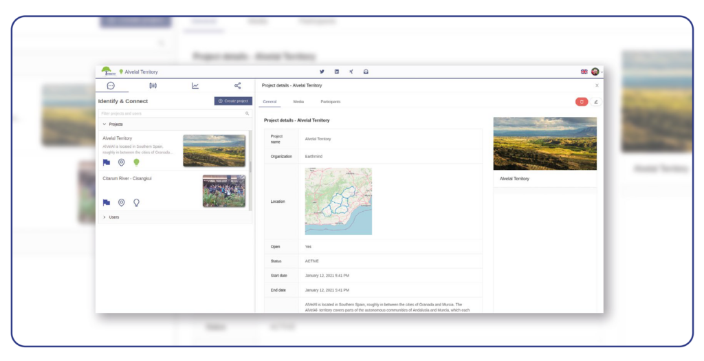
This is where the module “Identify & Connect” – which is free-of-charge – comes into play. A user registered on https://hermosa.earth and logged in, will show up in the user section of this module and can be found through the search mechanism. The user is now able to create projects by clicking on the ‘Create project’ button, uploading or digitizing the project boundary, entering relevant datainto the fields and providing some pictures to illustrate the activities. As soon as this project is saved it will be displayed with an icon on the map and can be found using the same search functionality previously described for users.

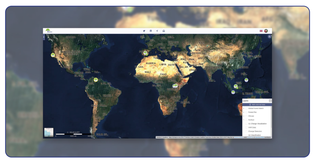
The matchmaking between stakeholders now becomes very easy. You can either use the search provided to look for the right keywords with a set of results to choose from or you can navigate on the map to identify relevant projects in your preferred location. With a click of a button you can send an email to the project owner and suggest a collaboration. Since users are asked to specify a role (e. g. planting organisation, logistics company, local government, university, finance institution etc.) and projects are tagged according to their topic (e. g. agro-forestry, biodiversity, wetland etc.) the filter will help to quickly localize interesting projects and stakeholders. Once the stakeholders have identified each other and connected the consortium building process takes place outside of this module through normal communication channels like email, phone, chat, personal meetings etc.

Contact sales@hermosa.earth today to get started!

reposted from https://hermosa.mundialis.de/news/feature-of-the-week-kw-11/

Comments are currently closed.

Follow Us

Contact

mundialis GmbH & Co. KG
Kölnstrasse 99
53111 Bonn

Phone: +49 (0)228 / 387 580 80
Fax: +49 (0)228 / 962 899 57

E-Mail: info [at] mundialis [dot] de

Latest News

  • FOSSGIS 2023 – this time in Berlin again!

    Tuesday February 21st, 2023
  • ++ Eine neue Heimat für Actinia ++

    Tuesday January 24th, 2023
  • Positive towards the future – Management changes at mundialis

    Tuesday October 4th, 2022
  • Recap of FOSS4G 2022 in Florence

    Friday September 16th, 2022
  • FOSS4G 2022 in “La Bella” – Greetings from Florence!

    Thursday July 14th, 2022
View all News

Blog

  • Satellite image of the month – March – Berlin (Germany) 7. March 2023
    Berlin – Germany, recorded by the Sentinel-2B satellite on September ...
  • Satellite image of the month – February – Amazon Rainforest (Brazil and Bolivia) 7. February 2023
    Amazon Rainforest – Brazil and Bolivia, recorded by the Sentinel-2A ...
  • Satellite image of the month – January – Yalu River (People’s Republic of China and Democratic People’s Republic of Korea) 2. January 2023
    Yalu River – People’s Republic of China and Democratic People’s ...
View all Blog Posts

Copyright © 2015-2023 mundialis GmbH & Co. KG

Imprint Privacy

Theme created by PWT. Powered by WordPress.org