Impervious surfaces affect the natural water cycle by reducing infiltration and increasing stormwater runoff. Reliable information on these surfaces is therefore of critical importance for water management associations and urban drainage utilities. A precise differentiation between roof surfaces, traffic areas, as well as private low-pollutant and high-pollutant surfaces enables a realistic representation of runoff volumes and pollutant loads entering receiving waters.
Areas of application
Fee calculation and fairness The precise detection and classification of impervious surfaces provides a transparent basis for calculating stormwater fees. Municipalities and water management associations can thus ensure a fair distribution of costs, as fees are directly linked to the actual extent of surface usage.
Planning and dimensioning of drainage systems The subdivision into relevant surface categories enables accurate modeling of runoff volumes. This allows sewer networks, retention basins, and stormwater treatment facilities to be dimensioned according to actual needs, preventing overloads and unnecessary investments.
Water protection and environmental management Surfaces with different levels of pollutant load (e.g., streets compared to roof surfaces) result in varying amounts of pollutants entering water bodies. With differentiated data, targeted measures for stormwater treatment can be developed, and legal requirements for water protection can be more effectively met.
Urban development and water management planning When developing new residential or commercial areas, surface information provides valuable input for infiltration and retention concepts. Planners can assess at an early stage how future impervious surfaces will impact the drainage system and incorporate appropriate mitigation measures into their designs.
AI-supported detection and analysis
The surface processor we developed automatically classifies digital orthophotos (DOPs) using neural networks. This orthophoto classification combines aerial imagery with elevation models to accurately identify different surface types. The classification results can be integrated with additional datasets—for example, ALKIS data can provide parcel-level delineation. The method relies entirely on freely available geospatial base data.
Do you need detailed information on impervious surfaces? Our data package for surface sealing provides high-resolution surface classification across multiple imperviousness categories.
Data availability
The calculation of impervious surfaces can be applied to all areas in Germany. Depending on the quality and characteristics of the available aerial imagery, the processor may need to be adapted. Application to areas outside Germany depends on the availability of input data.
Support in your decision-making process
Our “Impervious Surfaces” data package supports informed decision-making in water management.
The detailed information on impervious surfaces and their differentiated use provides our clients with a reliable foundation for fee calculation, drainage planning, and water protection measures, thereby enabling a more efficient and sustainable approach to addressing water management challenges.
Do you need a classification of impervious surfaces for your association’s area? Contact us!
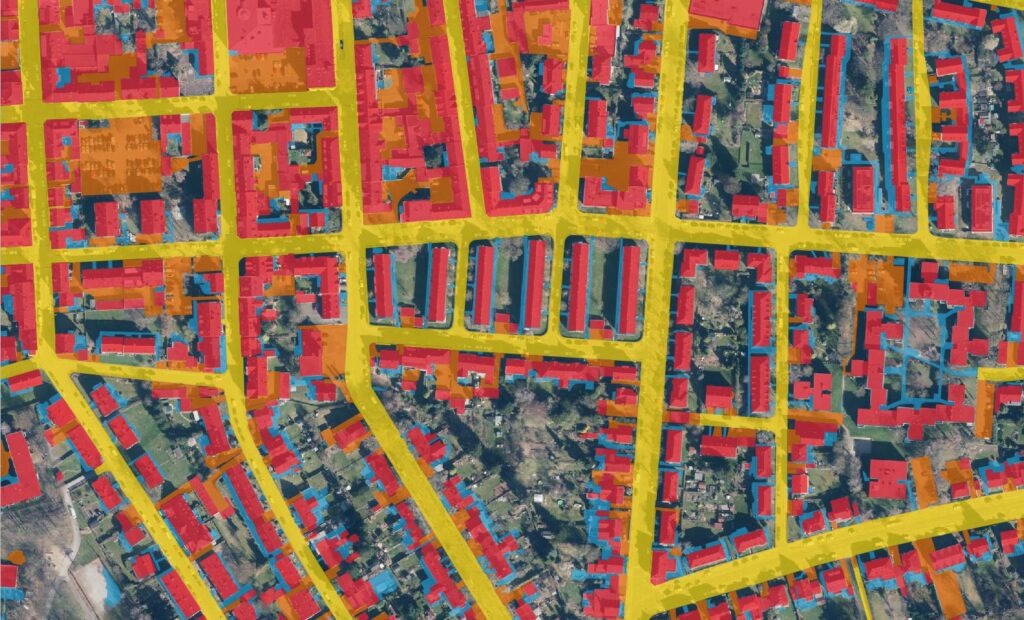
Differentiation of classes:
Roofs/buildings (red)
public traffic surfaces (yellow)
private low-pollutant surfaces (blue)
private high-pollutant surfaces (orange)
Accuracy of 90–96% on test datasets
Spatial resolution of approximately 20 cm (DOP resolution)
Deliverable as raster (GeoTIFF) or vector dataset (GeoPackage, ESRI Shapefile, etc.)
Based on freely available geospatial base data (DOPs, DEMs, etc.) and open-source software
AI model specifically trained to detect impervious surfaces relevant for water management