
Karachi – Pakistan – recorded by the Sentinel-2A satellite on December 29, 2023
Our satellite image of the month August shows the city of Karachi in Pakistan and its surrounding region.
The image is based on Sentinel-2 data from the EU Copernicus program. Sentinel-2 data are freely available, multispectral satellite images. After downloading, multiple scenes were merged and atmospherically corrected using open-source software. Subsequently, a colour composition was computed using three different bands.
Structure of the image
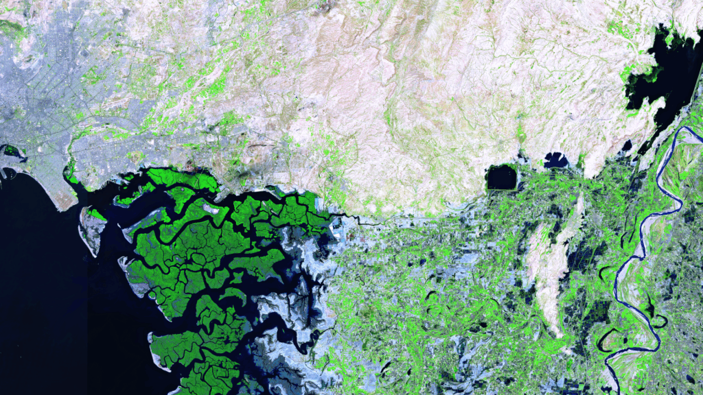
Vegetation analyses can be performed with this false color composition. This composite uses the bands 11 (short-wave infrared), 8A (visible and near-infrared) and 4 (visible red). In this composite healthy vegetation appears in vibrant shades of green, making it very easy to distinguish from soil, which ranges in colour from light pink (e.g. harvested fields) to vibrant pink (e.g. deforested rainforest). Water appears in shades of dark blue to black, while cities are coloured from light grey to light pink.
About the city and the surrounding area
Karachi is the largest city in Pakistan and the capital of Sindh Province, with a population of over 20 million people. It is located on the southern coast of Pakistan, northwest of the Indus Delta, on the Arabian Sea. Karachi is the country’s most important seaport and a major industrial, commercial, and financial centre. The metropolitan area covers approximately 3,530 km².
Founded in 1729 the city grew considerably during British colonial rule, particularly due to its role as a seaport and the construction of the railway. Following Pakistan’s independence in 1947, Karachi became the capital of the newly formed state. However, the capital was moved to Islamabad in 1959.
The landscape is characterized by coastal plains, rocky elevations and mangrove forests along the Arabian Sea. The surrounding area encompasses the extensive Malir district, coastal regions, and nearby cities, including Gadani (43 km northwest), Gharo (54 km east), and Hyderabad (141 km northeast). These cities are connected to Karachi by important road and rail networks.
Location on the satellite image
On the satellite image, Karachi can be identified by the grey-blue colours in the top left corner of the image. The Arabian Sea appears dark blue to black. To the south of Karachi lies the Indus Delta, home to numerous islands coloured in bright shades of green due to their dense vegetation, including mangrove forests. The Indus itself can be seen on the right-hand edge of the image. In between, grey-blue settlements and green agricultural areas are visible. The river’s actual mouth into the Arabian Sea is further south, outside the image. The upper part of the image is coloured in light brown, indicating a rather rocky area with sparse vegetation.
A different view of the region
The following animations help understanding the geographical location of the image. They show the location of the satellite image of the month at various scales and an overlay with OSM data. The map visualisations were created using the terrestris OpenStreetMap Premium service.


Contains modified Copernicus Sentinel data (2023)/ESA – created by mundialis
Satellite images for your wall available at: https://art-from-space.de