
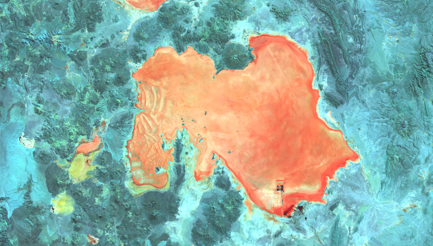
Salar de Uyuni – Bolivia, recorded by the Sentinel-2B satellite on July 22, 2023
Our satellite image of the month August shows the Salar de Uyuni, the largest salt flat on earth, and the surrounding area.
The image is based on Sentinel-2 data from the EU Copernicus program. Sentinel-2 data are freely available multispectral satellite images. After downloading, the scene was atmospherically corrected using free software and a color composition was calculated using three different bands.
Structure of the image
Bands 8, 11, and 12 with a spatial resolution of 20m were used for this composition. Bands 12 and 11 are from the shortwave infrared region while 8 measures reflectance in the visible and near infrared regions. The presence of short wavelength infrared sensors allows this composition to penetrate the atmosphere relatively well compared to shorter wavelengths. This makes the image appear much clearer. Water appears black, while the salt flat of the salt flat is rendered in shades of red. The dry and only sparsely vegetated surroundings are colored in green and turquoise.
About the salt flat
The Salar de Uyuni is located in the southwest of Bolivia at an altitude of 3,653 m and belongs to the landscapes of the Altiplano plateau. With an area of 10,582 km², the basin has a larger surface area than, for example, Lower Bavaria. It is almost free of any kind of living creatures, except for some flamingo species found only in South America. During the rainy season, the salt crust can be covered with several decimeters of water. With the exception of the muddy shore zones and individual water eyes (ojos), the salt crust, which can be up to 30 meters thick, can then be driven over even by buses and trucks. In the southeast of the salt flat lies the city of Uyuni, which is the starting point of tourist excursions to the Salar de Uyuni. Like for example to the island Isla Incahuasi (Quechua for house of the Inca) in the center of the salt pan, which is known for its many meter high and partly more than 1,200 years old columnar cacti.
The amount of salt in the Salar de Uyuni is estimated at about ten billion tons. Every year, about 25,000 tons of it are mined and transported to the cities. In addition, according to the U.S. Geological Survey, the Uyuni Salt Lake is believed to contain a gigantic deposit of 5.4 million tons of lithium. Because lithium batteries are used in many electronic devices, the mineral has become a valuable ressource with a continuously increasing demand. Bolivia’s President Evo Morales commissioned the project of a pilot plant for lithium extraction from the Salar de Uyuni in 2007, which was ultimately commissioned in January 2013.
Based on the false color composition, it is clear that Bolivia is currently in the dry season and the Salar is not covered by water. Water surfaces would be shown in black colors, but instead the surface of the salt pan appears almost uniformly in shades of red, standing out from its surroundings. To the south of the salt flat, the above mentioned industrial facilities for the extraction of lithium can be seen as rectangular dark and light patches. In the northeast, routes of vehicles across the salt surface are visible through a bright stripe.
Contains modified Copernicus Sentinel data (2023)/ESA – created by mundialis
More satellite images are available at https://maps.mundialis.de