
Panama Canal – Panama, recorded by the Sentinel-2A satellite on June 3, 2023
Our satellite image of the month November shows the Panama Canal, which connects the Pacific Ocean with the Atlantic Ocean in Central America.
The image is based on Sentinel-2 data from the EU Copernicus Programme. Sentinel-2 data consists of freely available multispectral satellite images. Two scenes were merged after download and atmospherically corrected using open-source software. Subsequently, a color composition was computed using three different bands.
Structure of the image
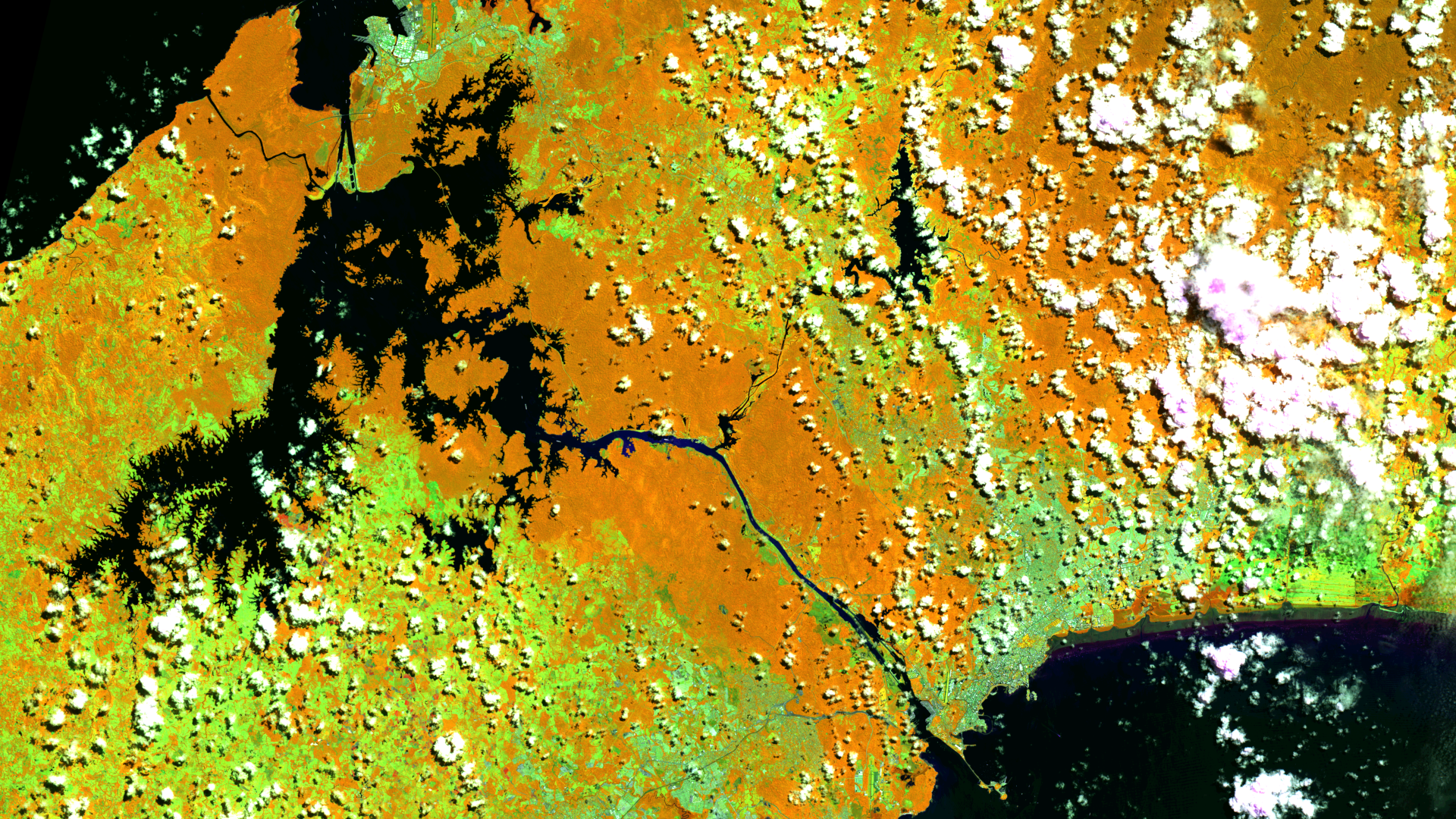
The chosen false-color composition distinguishes land and water effectively. This composition utilizes bands 8A (visible and near-infrared), 11 (shortwave infrared), and 4 (visible red), providing a spatial resolution of 20 meters. Healthy vegetation appears in orange, while older vegetation appears in green. Various shades of green represent the ground, while clouds are depicted in white. Water is depicted in shades of blue to black.
The image displays the Caribbean Sea as a subregion of the Atlantic in the upper left area, while in the lower righ corner, the Pacific Ocean is visible. Between the oceans, one can observe different sections of the 82-kilometer-long Panama Canal. The canal stretches from north to south from the city of Colón on Limón Bay on the Atlantic Ocean via the impounded Gatún Lake, the Rio Chagres and several subseqeunt locks to the Pacific Ocean where it ends in the Gulf of Panama south of Panama City. Colón and Limón Bay can be seen at the top left of the image (adjacent to the Pacific Ocean) and Lake Gatún is clearly visible in dark shades in the left part of the image. Locks enable ships to reach the lake, which is 26 metres above sea level. The entire transit through the canal takes approximately 8 to 10 hours.
Construction and importance of the canal
Initiated in the 19th century, the canal was officially opened on August 15, 1914, revolutionizing global trade by enabling ships to traverse between the Atlantic and Pacific without navigating the perilous journey around Cape Horn in South America. The Panama Canal remains one of humanity’s most remarkable engineering feats. Approximately five percent of global maritime trade passes through the canal, contributing nearly eight percent to Panama’s gross domestic product in 2013. However, due to severe water shortages since November 2023, the canal’s capacity has been reduced. Daily transits, typically numbering between 30 to 40, have been reduced to only 18 for February 2024.
The canal passes through various national parks and protected reserves inland. In the satellite image, these areas are identifiable by their orange hues, representing healthy vegetation. Cities like Colón in the north and Panama City in the south are distinguishable by their light green to nearly white tones, contrasting with the orange vegetation. Due to Panama’s geographical location and tropical climate, capturing cloud-free satellite images is challenging. This image is notably less cloudy than in previous years for the selected region.
Contains modified Copernicus Sentinel data (2023)/ESA – created by mundialis
More satellite images are available at https://maps.mundialis.de