
Venedig, Italien
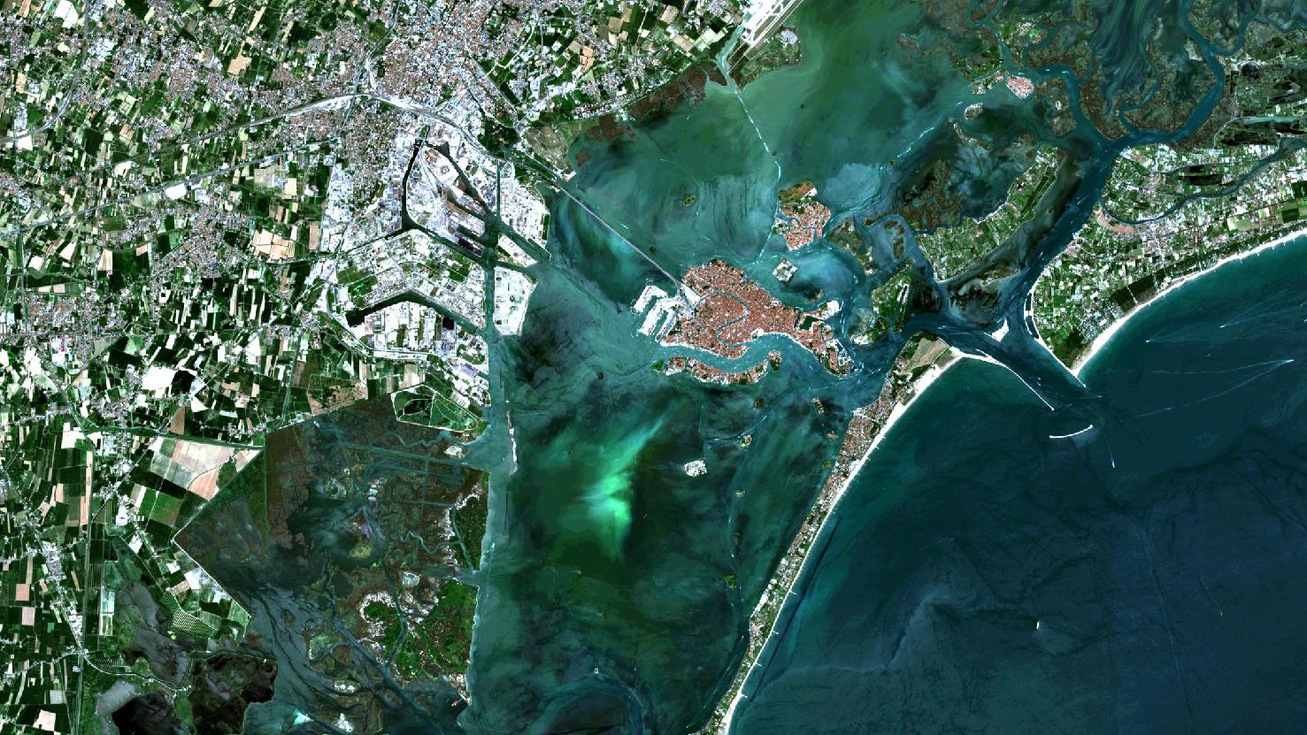
Das Satellitenbild des Monats Februar zeigt eine Echtfarben Kompostition der europäischen Kulturmetropole und dem UNESCO-Weltkulturerbe Venedig an der Adria. Das Bild wurde aus verschiedenen Bändern, basierend auf Sentinel-2A Daten des EU Copernicus Programms erstellt und bietet eine Auflösung von 10 Metern.
Gut auf dem Bild zu erkennen in rötlichen Farbtönen ist das historische Zentrum Venedigs, welches nur durch eine einzelne Brücke “Ponte della Liberta” mit dem Festland verbunden ist. Tatsächlich jedoch gehört ein weit größerer Teil zu Venedig: Die der Insel Venedig in länglicher Form vorgelagerte weitere Insel “Lido de Venezia”, alle Inseln welche in der Lagune um Venedig herum liegen, sowie ein großer Teil auf dem Festland. Auf dem Satellitenbild setzt sich der Festlandsbereich mit einer deutlich helleren Färbung in weiß und grau ab.
Zwischen der Halbinsel Lido, welche wegen ihrer Exposition vor allem Badegäste anlockt, sowie einem in die Lagune ragenden Festlandsarm, genannt Cavallino, liegt das von zwei Leuchttürmen flankierte “Eingangstor” zu Venedig. Dieses ist essentiell für die zahlreichen Boote, Schiffe und Kreuzfahrtschiffe welche Venedig ansteuern. Hier wird auch die einstige Bedeutung Venedigs, als eine der größten Handelsstädte Europas bis ins 16. Jahrhundert deutlich. Bei genauerer Betrachtung lässt sich der weltberühmte “Canale Grande” problemlos identifizieren, dieser fließt schlangenförmig durch das historische Venedig. Zahlreiche kleinere Kanäle fließen von dort zwischen den historischen Gebäuden, welche teilweise noch aus dem 15. Jahrhundert stammen, hindurch.
In den Wintermonaten tritt in der Lagunenstadt häufig das Phänomen eines niedrigen Wasserpegels auf, der häufig dazu führt, dass die kleineren Nebenkanäle austrocknen. Anfang Februar lag der Pegelstand teilweise 60cm unter dem Meeresspiegel und sorgte somit dafür, dass die bekannten venezianischen Gondeln auf Grund lagen. Wenig Regen und auch der “Super-Blau-Blutmond” tragen zum niedrigen Wasserstand in Venedig bei.
Ebenso wie im Rheinland und zahlreichen weiteren Regionen weltweit, wird auch in Venedig Karneval gefeiert. Traditionell beginnt dieser 10 Tage vor Aschermittwoch (meist im Februar) und endet auch zur Fastenzeit. Schon im 13. Jahrhundert n. Chr. gibt es Nachweise, dass in Venedig Karnevalsfestivitäten mit Kostümierung ausgetragen wurden.
Generell gilt die Region um Venedig (“Venetien”) als besonders prosperierend im Vergleich zu südlicheren italienischen Provinzen. Dies ist nicht zuletzt auf den Strukturwandel zurückzuführen, welcher im letzten Jahrhundert stattgefunden hat: Venetien wandelte sich von einem landwirtschaftlich geprägten Gebiet zu einer Industrieregion. Auf dem Satellitenbild lassen sich trotz alledem noch zahlreiche landwirtschaftlich genutzte Felder identifizieren durch ihre charakteristische “Flickenteppich”-Struktur im Nordwesten der Metropole Venedig.
Contains modified Copernicus Sentinel data (2017-2018)/ESA – created by mundialis
Weitere Satellitenbilder gibt es unter https://maps.mundialis.de
Die Erde als Kunstwerk: https://art.mundialis.de