
Helsinki – Finland, recorded by the Sentinel-2A satellite on June 23, 2023
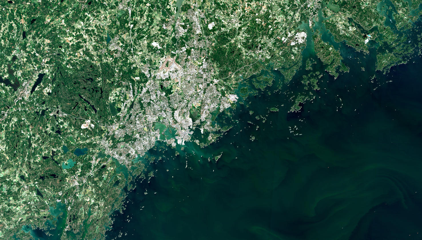
Our satellite image of the month July shows Helsinki, the capital of Finland, and its surroundings.
The image is based on Sentinel-2 data from the EU Copernicus program. Sentinel-2 data are freely available multispectral satellite images. After the download, the scene was atmospherically corrected using free software and a color composition was calculated using three different bands.
This „natural color“ band combination is as close to „true color“ as is possible with a Sentinel-2 image. Because the three visible bands are used which we see as red, green and blue, the image appears in colors which are similar to their appearance to the human eye. Vegetation is green, recently cleared fields are very light, soil is yellow and brown and roads and buildings are gray to white. The three bands provide a spatial resolution of 10 meters.
Helsinki is located in the Uusimaa landscape in the south of the country on the coast of the Gulf of Finland and is the northernmost capital of an EU member state. With over 664,000 inhabitants (as of 2022), Helsinki is by far the largest city in Finland and the third largest city in the Nordic countries, after Stockholm and Oslo.
Together with the neighboring cities of Espoo, Vantaa and Kauniainen, it forms the so-called Capital Region, a metropolitan area of about 1.49 million inhabitants, making it the northernmost metropolitan area in the world with over one million inhabitants. The capital region has an area of 765 km². Although this is only 0.2% of Finland’s area, it is home to about one-fifth of the country’s population.
In total, almost 90% of the country’s area is covered with forest or water. Along the Finnish coast there are small offshore islands, so-called skerries. The Helsinki city alone includes about 300 such islands, of which more than half are smaller than 0.5 ha and only about 50 islands are larger than 3 ha.
The satellite image shows the entire urban capital region in gray to white tones, clearly delineated from the forested and agricultural surroundings, which are shown in green tones, and the Baltic Sea to the south. The sea is depicted in dark blue and green tones depending on the depth of the water, while the shallow water areas between the numerous skerries on the coast appear in lighter turquoise tones.
Also clearly visible, are the numerous lakes surrounding the city. Especially in the left part of the picture, west of the Finnish capital, the lakes, coloured in different shades of blue, due to differing water depths, are visible between the green of the forests and the fields. Finland is one of the lake richest countries and is also called the “land of a thousand lakes”.
In the last week of June, mundialis attended the MOOD Scientific Conference and the MOOD General Assembly in Helsinki from 27 – 29 June 2023. The MOOD H2020 project (MOnitoring Outbreak events for Disease surveillance in a data science context) is an EU project within the framework of One Health. mundialis is involved in the project as a data provider of relevant covariates for modelling the MOOD model diseases. At the Scientific Conference, exciting topics were presented and afterwards, during the annual General Assembly, the project status was discussed among the project partners and the next steps were planned. You can find more information on the MOOD project on the official project website.
Contains modified Copernicus Sentinel data (2023)/ESA – created by mundialis
More satellite images can be found here: https://maps.mundialis.de