
Viti Levu, Fidschi
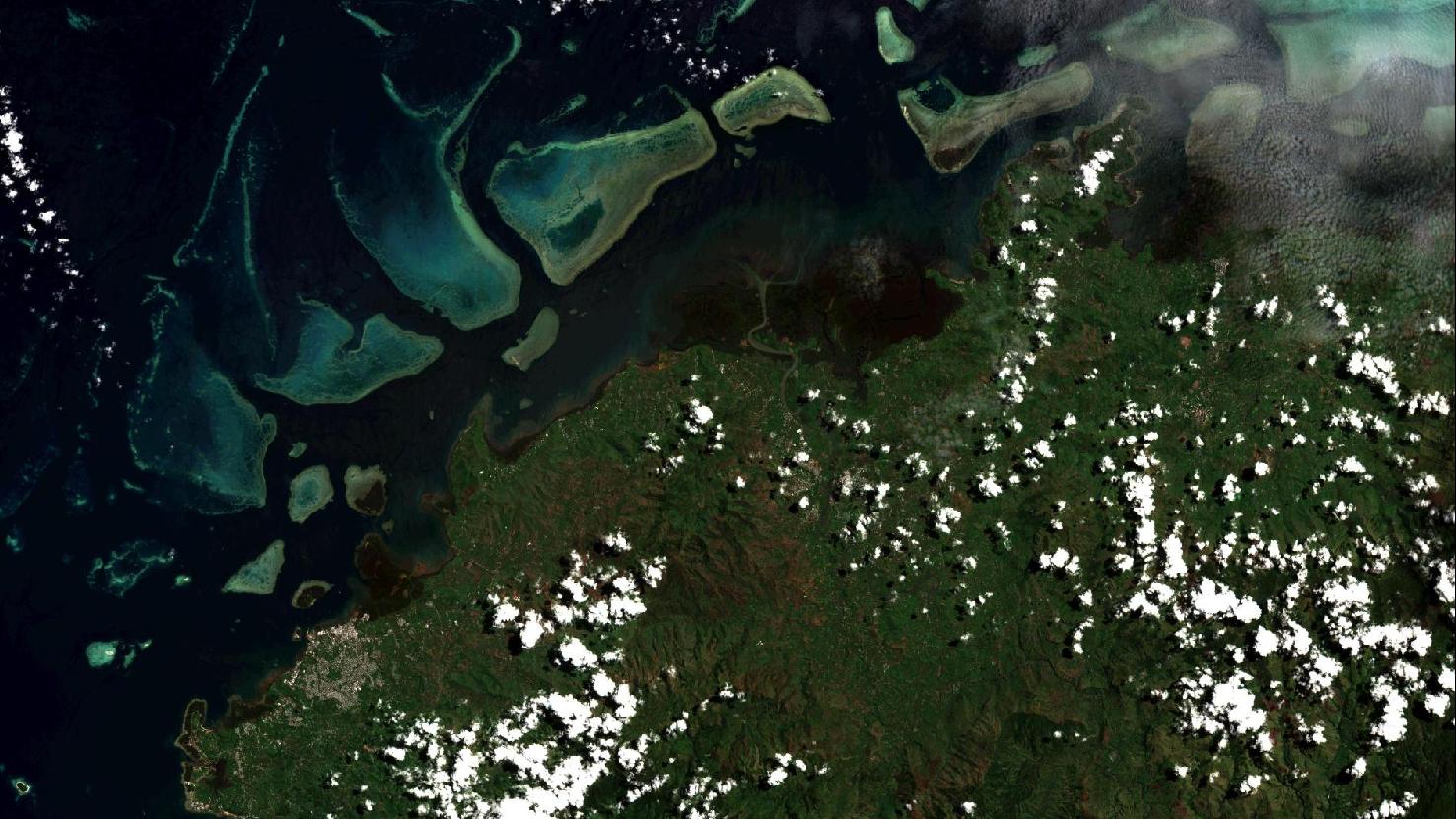
Das Satellitenbild des Monats November wurde vom europäischen Sentinel 2A Satelliten aufgenommen. Es zeigt in Echtfarben den nördlichen Teil der Insel Viti Levu, der Hauptinsel des Staates Fidschi im südpazifischen Ozean. Im westlichen Teil des Satellitenfotos befinden sich die nur wenig bevölkerten Inseln Bekana Island und die kleinere Nachbarinsel Vio Island gegenüber der Küstenstadt Lautoka auf der Hauptinsel. Die wenigen Wolken im Inland der Insel Viti Levu weisen darauf hin, dass die Fidschi Inseln in der Regenzeit von November bis April häufig wolkenbedeckt und regenreich sind. Doch dieses vermeintliche Idyll ist akuter Bedrohung ausgesetzt.
Es wird erwartet, dass der Staat Fidschi besonders von den Folgen des Klimawandels betroffen sein wird. Anders als in anderen Teilen der Welt verfügen die Fidschi Inseln, ebenso übrigens wie zahlreiche weitere Inselgruppen, nicht über die finanziellen Mittel und Möglichkeiten, Maßnahmen gegen den Anstieg des Meeresspiegels zu ergreifen um sich zu schützen. Die zahlreichen, zumeist sehr flachen Inseln, machen einen Schutz gegen den steigenden Meeresspiegel zudem faktisch unmöglich.
Um genau auf diesen Missstand aufmerksam zu machen, wurde die diesjährige Weltklimakonferenz (COP23) unter die Leitung des vom Untergang bedrohten Inselstaates Fidschi gestellt, gleichwenn der Austragungsort aus logistischen Gründen nach Bonn verlegt wurde.
Auf unserem Satellitenbild lässt sich die ernste Lage des Staates sehr gut aufzeigen. Nördlich der Hauptinsel sind mehrere knapp unter der Wasseroberfläche liegende kleine Atolle und Korallenriffe erkennbar. Inselgruppen wie diese sind typisch für Fidschi, genauso wie für viele weitere Inselstaaten im pazifischen Ozean. Nur die Inseln mit einem besonders dunklen inneren Teil liegen noch wenige Zentimeter über der Meeresoberfläche, so dass diese mit Bäumen, Sträuchern oder Mangroven bewachsen sind. Bei einem langsamen Anstieg des Meeresspiegels, hätten diese Atolle und Korallenriffe, die Möglichkeit mit dem Anstieg Schritt zu halten. Beim prognostizierten schnellen Anstieg der kommenden Jahre, haben die Korallen allerdings keine Chance mitzuhalten.
Ein Meeresanstieg von nur wenigen Zentimetern wird dafür sorgen, dass besonders flache Inselstaaten wie Tuvalu oder die Marshallinseln als erstes von den Landkarten verschwinden werden.
Bereits jetzt beginnt die Versalzung des spärlichen Bodens durch ansteigendes Meerwasser und macht diese unbewohnbar. Zwar sind diese häufig noch nicht gänzlich versunken, jedoch sorgt der hohe Salzgehalt dafür, dass ganze Dörfer und Städte ins Inland umgesiedelt werden müssen.
Es bleibt abzuwarten, ob die Beschlüsse und die darauf erfolgenden Umsetzungen der Bonner Klimakonferenz, weitreichend genug sind, diese bedrohten Kleinode unseres Planeten zu bewahren.
Contains modified Copernicus Sentinel data (2016)/ESA – created by mundialis
Weitere Satellitenbilder gibt es unter https://maps.mundialis.de
Die Erde als Kunstwerk: https://art.mundialis.de