
Inn Valley – Austria, recorded by the Sentinel-2B satellite on October 28, 2023
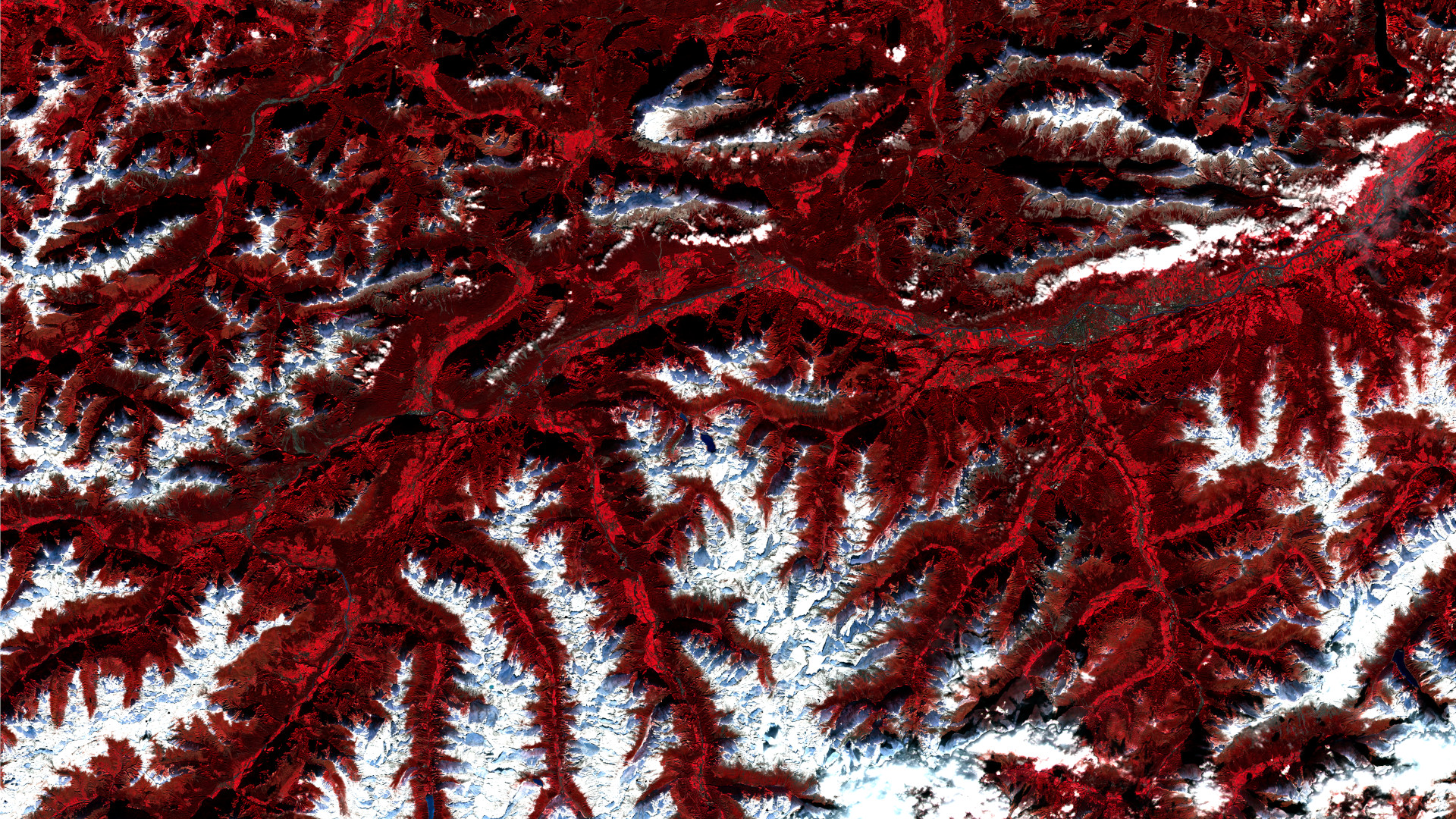
Our satellite image of the month November shows the Inn Valley in the region around Innsbruck in Tyrol, Austria, as well as the surrounding mountain ranges of the Alps.
The image is based on Sentinel-2 data from the EU Copernicus program. Sentinel-2 data are freely available, multispectral satellite images. After the download, two scenes were merged and atmospherically corrected using free software. A color composition was then calculated using three different bands.
Structure of the image
For the false color composition shown here, bands 8 (near infrared), 4 (red) and 3 (green) were used. In general, the color infrared representation is particularly suitable for the recognition of vegetation. Healthy vegetation appears in various shades of red, older vegetation in green. Soil is shown in shades of brown and green and urban regions in blue-grey. In this case, this composition was chosen to emphasize snow, which is shown in white, against the rest of the surfaces. The selected bands allow a high spatial resolution of 10 meters.
The picture shows the Upper Inn Valley and the beginning of the Lower Inn Valley, which stretches (horizontally) from the southwest to the east. In addition, some side valleys of the Inn Valley are clearly visible between the snow-covered mountain ranges. In the lower left part of the picture, for example, the Kaunertal, Pitztal and Ötztal valleys can be seen (vertically) from left to right.
In the right-hand part of the picture, Tyrol’s capital Innsbruck can be seen in grey tones. With over 130,000 inhabitants, it is the fifth largest city in Austria. South of Innsbruck, the Stubai Valley and the Wipp Valley begin, through which the Brenner highway leads south over the Brenner Pass to South Tyrol. The route over the Brenner Pass, which was completed in 1971, is one of the most important and busiest north-south traffic routes through the Alps. Around 2 million trucks cross the pass every year.
To the north of Innsbruck are the Karwendel mountains, and to the west are the Wetterstein mountains with the Zugspitze as their highest peak on the border between Austria and Germany.
The first snow
While the valleys appear clearly in shades of bright red, indicating healthy vegetation, the higher elevations of the mountain ranges are already covered in snow and are depicted in white in this false color composition. In particular, the Stubai and Ötztal Alps, with peaks up to 3,700 meters high, which are located in the middle of the lower half of the picture, form a large white area. The Zugspitze massif is also clearly visible as a single white area in the middle of the top image section.
A comparison with satellite images from mid-October shows that, apart from a few very high altitudes, the snow has only fallen in the last two weeks. However, most of this snow and the snow that will continue to fall in the Alps during the coming winter will not melt until next spring and run off via the rivers. In order to include as much of the autumn snow as possible in the annual hydrological balance, the so-called hydrological year or runoff year begins on November 1 and ends on October 31 in Germany and now also in Austria. In Switzerland, the hydrological year even starts on October 1.
Contains modified Copernicus Sentinel data (2023)/ESA – created by mundialis
More satellite images are available at https://maps.mundialis.de