
Satellite image of the month – October – Aachen/Maastricht (Germany/Netherlands)
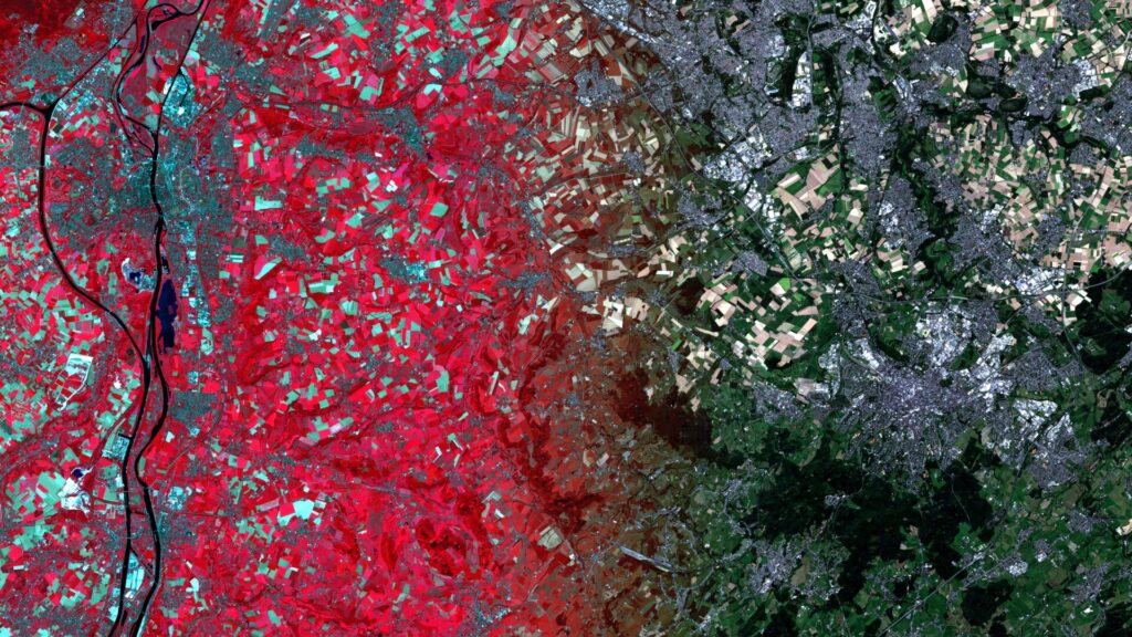
Aachen/Maastricht – Germany/Netherlands– recorded by the Sentinel-2A satellite on August 11, 2025 Our satellite image of the month for October shows the border region between the Netherlands, Germany and Belgium around the cities of Aachen and Maastricht. The image is based on Sentinel-2 data from the EU Copernicus Programme. Sentinel-2 data consists of freely available multispectral satellite images. Multiple scenes were merged […]
Satellite image of the month – September – Lofoten (Norway)
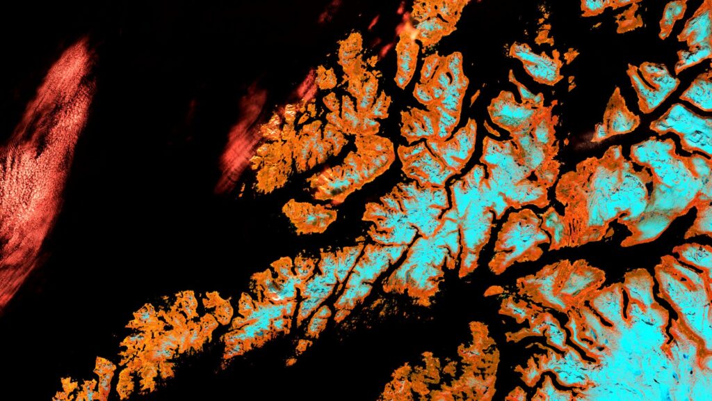
Lofoten – Norway – recorded by the Sentinel-2B satellite on May 17, 2024 Our satellite image of the month for September shows the archipelago Lofoten in Norway. The image is based on Sentinel-2 data from the EU Copernicus Programme. Sentinel-2 data consists of freely available multispectral satellite images. Multiple scenes were merged after download and atmospherically corrected using open-source software. […]
Satellite image of the month – August – Karachi (Pakistan)
Karachi – Pakistan – recorded by the Sentinel-2A satellite on December 29, 2023 Our satellite image of the month August shows the city of Karachi in Pakistan and its surrounding region. The image is based on Sentinel-2 data from the EU Copernicus program. Sentinel-2 data are freely available, multispectral satellite images. After downloading, multiple scenes were merged and atmospherically corrected […]
Satellite image of the month – July – Vienna (Austria)
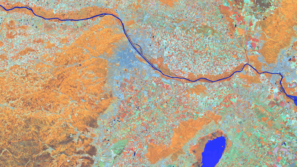
Vienna – Austria – recorded by the Sentinel-2A satellite on June 13, 2025 Our satellite image of the month for July shows the Austrian capital Vienna and the surrounding region. In the last week of June, the Living Planet Symposium 2025, one of the largest conferences on Earth observation, took place there. Structure of the image The image is based on Sentinel-2 data from […]
Satellite image of the month – June – Dalhart (Texas, USA)
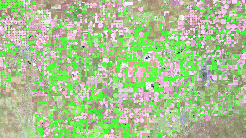
Dalhart – Texas, USA, captured by the Sentinel-2A satellite on May 16, 2025. Our satellite image of the month of June shows the area surrounding Dalhart in Texas, which is characterised by agriculture and a special irrigation technique. Structure of the image The image is based on Sentinel-2 data from the EU Copernicus Programme. Sentinel-2 […]
Satellite image of the month – May – Banks Peninsula (New Zealand)
Banks Peninsula – New Zealand, imaged by the Sentinel-2C satellite on 22.01.2025 Our satellite image of the month of May shows the Banks Peninsula and the city of Christchurch on the east coast of New Zealand’s South Island. Structure of the Image The image is based on Sentinel-2 data from the EU’s Copernicus program. Sentinel-2 […]
Satellite image of the month – April – Atacama Desert (Chile)
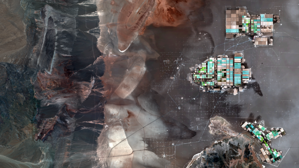
Atacama Desert – Chile, taken by the Sentinel-2B satellite on 23.03.2025 Our satellite image of the month of April shows a section of the Atacama Desert in northern Chile, in which industrial plants for the extraction of lithium can be seen. The image is based on Sentinel-2 data from the EU Copernicus program. Sentinel-2 data […]
Satellite image of the month – March – Münster (Germany)
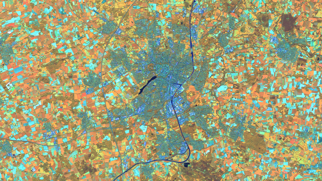
Münster – Germany – recorded by the Sentinel-2A satellite on September 20, 2024 Our satellite image of the month March shows the city of Münster and its surroundings in the north of the German state of North Rhine-Westphalia. Structure of the image This image shows a color composite created from different bands based on Sentinel-2 […]
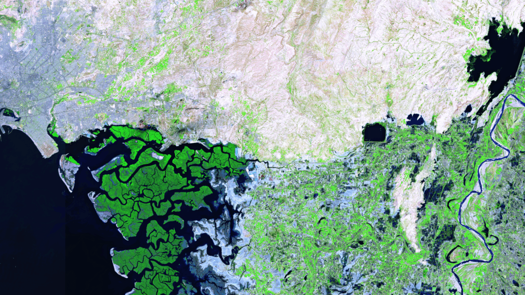
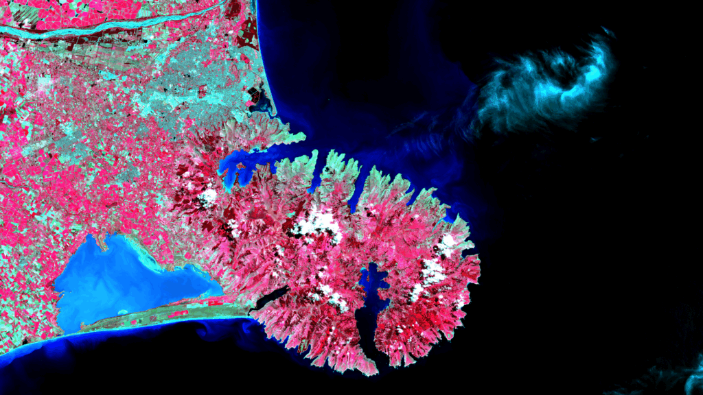
Satellite Image of the Month – February – Mangoky Delta (Madagascar)
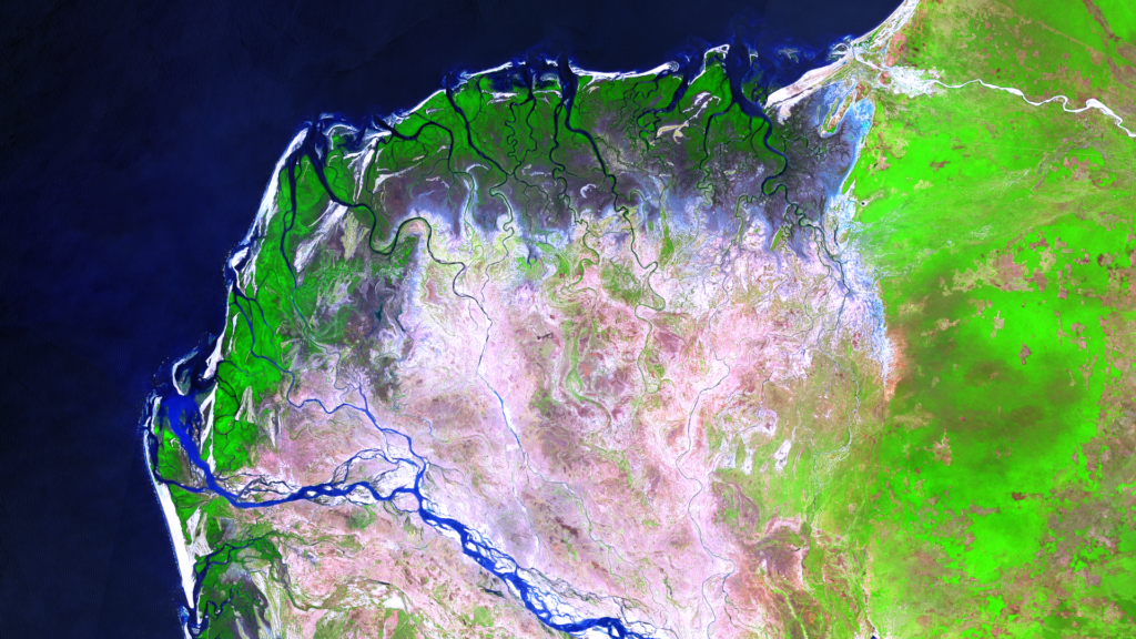
Mangoky Delta – Madagascar, captured by the Sentinel-2B satellite on January 10, 2025 Our satellite image of the month for February features the delta of the Mangoky River on the west coast of Madagascar. Image Composition The image is based on Sentinel-2 data from the EU Copernicus Program. Sentinel-2 data consists of freely available multispectral […]
Satellite Image of the Month – January – Malaspina Glacier (Alaska, USA)
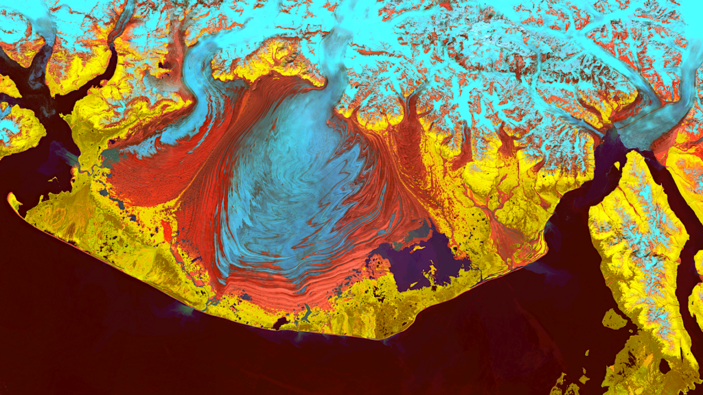
Satellite Image of the Month January 2025: Malaspina Glacier (Alaska, USA) Our Satellite Image of the Month for January features the Malaspina Glacier on Alaska’s Pacific Coast. Structure of the image The image is based on Sentinel-2 data from the EU Copernicus program. Sentinel-2 data are freely available, multispectral satellite images. After downloading, multiple scenes […]