
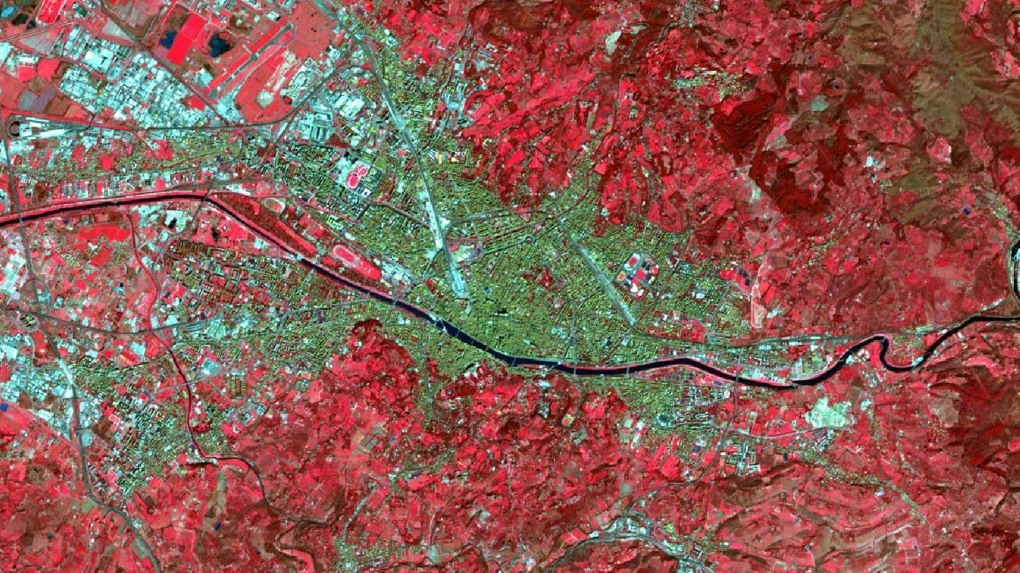
Florence – Italy, recorded by the Sentinel-2A satellite on March 09, 2022
The satellite image of the month August shows the Italian city of Florence, which is the venue of the FOSS4G conference 2022.
The image shown is based on multispectral freely available satellite data from the Sentinel-2 satellite of the EU Copernicus program. After downloading, atmospheric correction and computation of a false color composite with three bands (8 (NIR), 4 (Red) and 3 (Yellow)) was performed within free software.
The selected color infrared composite is particularly well suited for the detection of vegetation. Vegetation appears in various shades of red, older vegetation in green, soil in shades of brown and green, urban regions in blue-gray, clouds, snow and ice are light turquoise or white.
Florence (Italian: Firenze) is a major Italian city in Tuscany. With a population of 372,038, it is the eighth largest city in Italy.
In the late Middle Ages, Florence was a European commercial and financial center, making it one of the richest cities of the 15th and 16th centuries. Due to its cultural importance as the cradle of the Renaissance and especially of the fine arts, the city is famous for its history and is thus also called the “Italian Athens”. This is underlined by the past presence of numerous artists and clerics, such as Leonardo da Vinci, Michelangelo and Galileo Galilei.
The river Arno, which flows through the old town and is characteristic for the city, is displayed as a dark line from the left to the right image boundary. In the past, it contributed to the supply of the people as a trade route. However, it was also the cause of destruction by floods and thus did not only bring benefits to Florence.
In the south of the city rise the hills of the Chianti, also known to wine lovers. In the north the range of hills of the Tuscan-Emilian Apennines is located. Towards the Mediterranean west coast, you can find famous cities such as Lucca and Pisa. To the north of Florence lies the large city of Bologna. Due to its location Florence has very warm summers and cold, humid winters, with a wide range of temperatures from -23°C (min.) to 44°C (max.).
With buildings such as the Basilica di San Lorenzo and the Cathedral of Santa Maria del Fiore (central in the picture, visible north of the Arno and southeast of the train station, which is also central in the picture and to the north of the small peninsula in the river), the city reflects its architectural importance. The historic center of the city has been a World Heritage Site since 1982.
From August 22 – 28, 2022, the FOSS4G conference will be held at the Firenze Fiera Congress & Exhibition Center in the heart of Florence. The Santa Maria Novella Central Station and Santa Maria del Fiore Cathedral are within walking distance. FOSS4G is an annual global event hosted by OSGeo. The focus is on free and open source software for application to Earth observation and geospatial data. Thus, topics such as software development, applications, education and research up to Open Data are represented. As usual, mundialis will be there as well, presenting current input. You can find the complete program of the FOSS4G 2022 here.
Contains modified Copernicus Sentinel data (2022)/ESA – created by mundialis
More satellite images can be found here: https://maps.mundialis.de