
Urner und Glarner Alpen in der Schweiz, aufgenommen vom Sentinel-2A Satelliten am 05. Mai 2016
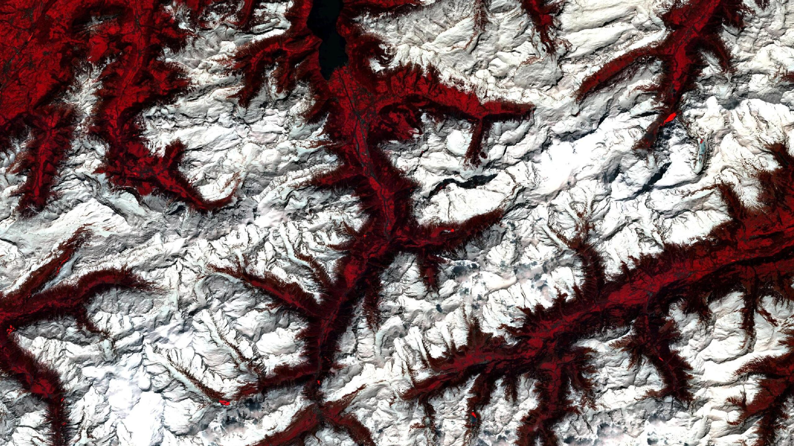
Dieses Bild zeigt eine Infrarot-Falschfarben Komposition der Grenze der Urner und Glarner Alpen in der Schweiz.
Das Bild wurde aus verschiedenen Bändern, basierend auf Sentinel-2A Daten des EU Copernicus Programms, erstellt. Die verwendete Bandkombination ist nützlich, um Vegetation zu erkennen und bietet eine Auflösung von 10 Metern. Vitale Vegetation erscheint in grellen Rottönen, während ältere Pflanzen in dunkleren oder blasseren Rottönen erscheinen. Wasser ist in dunklen Blau- bis Schwarztönen gemalt, während Städte grau bis bräunlich eingefärbt sind.
Mithilfe der Infrarot-Falschfarben Komposition erkennt man den Unterschied zwischen schneebedecktem Gebirge und freiliegenden Tälern. Die Täler, die rot erscheinen, sind von Wald und Weiden bedeckt. In jedem Tal erkennt man Ackerbau in helleren Rottönen, die von vegetationsfreien Straßen in schwarz und grau durchzogen werden. Auch Flüsse heben sich so ab und kleine Orte erscheinen als graue Flecken.
Zentral ganz im Süden liegt der Tomasee, auch Lai da Tuma genannt. Er wird als Rheinquelle angesehen, ist hier jedoch nicht von seiner Umgebung zu unterscheiden, da er von Schnee bedeckt ist. Von dort fließt der Vorderrhein durch die Surselva (rätoromanische Name für „oberhalb des Waldes“), eine Talschaft, deren Haupttal im Bild im Südosten in Rottönen erkennbar ist.
Etwas weiter westlich des Tomasees verläuft die Reuss von Süd nach Nord, die im weiteren Verlauf zum viertgrößten Fluss der Schweiz werden wird. Sie entspringt im Gotthardmassiv, dessen nördlicher Teil im Süden des Bildes zu sehen ist. Ihr Tal prägt rot eingefärbt die Mitte des Bildes. Sie fließt durch Andernmatt, als grauer Fleck im Süden des Bildes zu sehen und etwas weiter nördlich durch Göschenen, wo der Gotthardtunnel und der Gotthard Straßentunnel in Richtung Süden ins Bergmassiv führen. Der Gotthard-Straßentunnel ist mit 16,9 km Länge der viertlängste Straßentunnel der Welt.
Folgt man der Reuss weiter nach Norden, gelangt man nach Erstfeld, wo der Gotthard-Basistunnel beginnt. Er ist mit 57 km Länge der längste Eisenbahntunnel der Welt.
Im Norden des Bildes fließt die Reuss durch den Vierwaldstättersee, den man schwarz eingefärbt im Norden des Bildes erkennen kann. Er wurde wegen den vier an ihn angrenzenden Waldstätten (heutige Kantone) Uri, Schwyz, Unterwalden (heute Nid- und Obwalden) und Luzern so genannt und entstand in den Eiszeiten durch Erosion des Reussgletschers.
Zu den höchsten Gipfeln auf dem Bild gehören westlich der Reuss in den Urner Alpen das Sustenhorn mit 3.503 Metern Höhe und östlich der Reuss in den Glarner Alpen der Oberalpstock mit 3.328 Metern Höhe. Ganz im Südwesten des Bildes sind mit dem Ritzlihorn in 3.282 Metern Höhe auch die Berner Alpen vertreten.
Contains modified Copernicus Sentinel data (2016)/ESA – created by mundialis
To see more maps, visit: https://maps.mundialis.de
To enjoy Earth as Art, visit: https://art.mundialis.de