
Die Camargue im Süden Frankreichs (Rhonedelta)
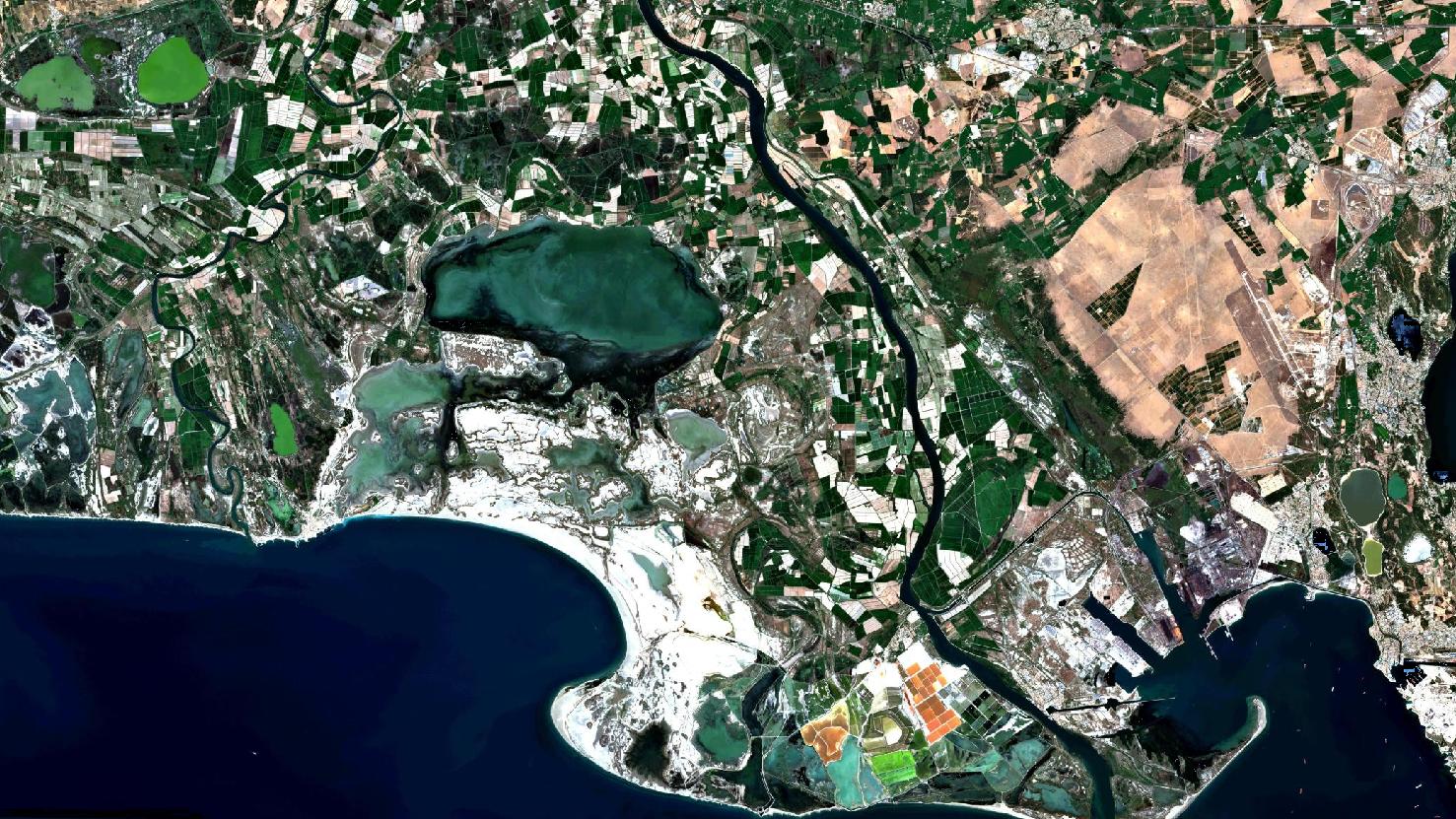
Das Satellitenbild des Monats Juli zeigt ein Echtfarbenbild der Camargue Region im Süden Frankreichs. Das Bild wurde aus verschiedenen Bändern, basierend auf Sentinel-2A Daten des EU Copernicus Programms erstellt und bietet eine Auflösung von zehn Metern.
Nach dem Download wurde die Szene mit freier Software atmosphärenkorrigiert und mit drei verschiedenen Bändern eine Farbkomposition berechnet.
Die Camargue, welche sich im Südwesten der Provence befindet, wird von zwei Flussarmen der Rhone eingegrenzt. Weiter nördlich und im Satellitenbild nicht zu erkennen, bei Arles, teilt sich der Hauptstrom auf.
in der rechten Bildhälfte ist der Hauptarm der Rhone deutlich zu erkennen, welcher ins Mittelmeer fließt. Dieser bildet die natürliche östliche Grenze der Camargue. Im linken Bereich des Bildes zeigt sich bei näherer Betrachtung, dass diekleine Rhone ins Mittelmeer fließt und den Park westlich einschließt.
Die Landschaft Camargue (“Grande Camargue”) ist abzugrenzen von dem in ihr befindlichen, circa 600 km2 großen Naturpark Camargue (“Parc naturel régional de Camargue”), welcher zu einem großen Teil aus Schwemmlandflächen besteht.
Die Grande Camargue ist bekannt als Natur- und Landschaftsschutzgebiet mit einem außergewöhnlichen Artenreichtum, besonders in der Fauna.
Mittig auf dem Satellitenbild in dunkelgrün zu erkennen ist der im Naturschutzgebiet befindliche “Étang de Vaccarès”, ein flacher salziger Strandsee. Er ist der größte See im Naturschutzgebiet.
Südlich vom Étang de Vaccarès zum Meer hin, farblich abgrenzend in weiß und grün, liegt der restliche Teil des Naturschutzgebietes.
Dort befinden sich mehrere salzhaltige kleinere Lagunen, sowie Inseln und Halbinseln. Das gesamte Gebiet bietet zahlreichen Zugvögeln Lebensraum, u.a. auch den in der Camargue bekannten rosa Flamingos. Eine weitere Attraktion sind die “Camargue Pferde”, eine Rasse, welche ausschließlich in der Camargue zu finden ist, sowie die “Camargue Stiere”. Beide Arten leben zwar in freier Wildbahn, haben jedoch immer einen Besitzer und sind daher keine wilden Tiere.
Weiterhin markant auf dem Satellitenbild sind die besonders im Süden gelegenen braunen und dunklegrünen quadratischen Meerwassersalinen. Diese sehr nah am Meer gelegenen Becken sind bekannt für das aus Meerwasser gewonnene “Fleur de Sel”.
Weiter Richtung Osten liegen die Gemeinden Port-Saint-Louis-du-Rhône und Fos-sur-Mer. Zwischen beiden Gemeinden fließt der “Canal Saint-Louis”. Auf dem Satellitenbild ist der Kanal gut sichtbar durch die fast 90° abknickende Linkskurve und einer anschließenden linearen Flussstrecke zur Rhone hin. Sowohl Port-Saint-Louis-du-Rhône als auch Fos-sur-Mer sind durch auffällige Hafen- und Industrieanlagen geprägt.
Contains modified Copernicus Sentinel data (2016)/ESA – created by mundialis
Weitere Satellitenbilder gibt es unter https://maps.mundialis.de
Die Erde als Kunstwerk: https://art.mundialis.de