
Australien – Eighty Mile Beach
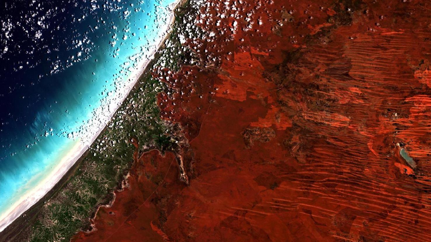
Das Satellitenbild des Monats Juli zeigt eine Echtfarben-Komposition des “Eighty-Mile-Beach” an der Westküste Australiens. Das Bild basiert auf Sentinel-2 Daten des Copernicus Programmes. Sentinel-2 Daten sind multispektrale Satellitenaufnahmen, die frei verfügbar sind. Nach dem Download wurde die Szene mit freier Software atmosphärenkorrigiert und mit drei verschiedenen Bändern eine Farbkomposition berechnet.
Das Bild zeigt eine sehr charakteristische Landschaft für Australien: In der linken Bildhälfte zieht sich der weiße Küstenstreifen sowie ein Ausschnitt des indischen Ozeans durch, während in der rechten Bildhälfte die charakteristische rostbraune Erde die sogenannte “Große Sandwüste” kennzeichnet. Einige einzelne kleine Wolken scheinen vom Meer ins Inland geschoben zu werden, jedoch spenden diese kaum Schatten. Ein schmaler Streifen von spärchlichem Pflanzenbewuchs verläuft parallel zum schneeweißen Strand und begrünt die ansonsten sehr karge Landschaft des australischen Westens.
Der Eighty Mile Beach ist ein Strandbereich von etwa 220 Kilometern Länge und 100 Metern Breite, welcher sich zwischen den westaustralischen Städten Broome und Port Hedland befindet. Das Feuchtgebiet, welches geschützt von der Ramsar-Konvention von internationaler Bedeutung ist, ist einer der bedeutendsten Orte für Watvögel in Australien. Große Teile des Eighty Mile Beaches sind traditionelles Eigentum der australischen Ureinwohner, der Aborigines, und werden für Zeremonien oder Erzählungen genutzt.
Die an den Eighty Mile Beach ins Inland angeschlossene Große Sandwüste ist eine 267.250 km2 große Wüste welche sehr dünn besiedelt ist. In der Großen Sandwüste lebten vor der europäischen Kolonisation die Aborigines nomadisch als Jäger und Sammler. Die Landschaft ist geprägt von Sandebenen und -dünen. In Western Australia erstrecken sich die bis zu hundert Kilometer langen Dünen in nordwestlicher Richtung und im Northern Territory in unterschiedliche Richtungen, diese sind dort auch wesentlich kleiner. Das Klima im Norden der Wüste ist tropisch-arid und je weiter es in den Süden reicht, wird es tropisch-gemäßigt. Regen fällt nur während des Monsuns in den Sommermonaten, vor allem im Norden.
Contains modified Copernicus Sentinel data (2017-2018)/ESA – created by mundialis
Weitere Satellitenbilder gibt es unter https://maps.mundialis.de
Die Erde als Kunstwerk: https://art.mundialis.de