
Guelb er Richat (Eye of Africa) in der Sahara
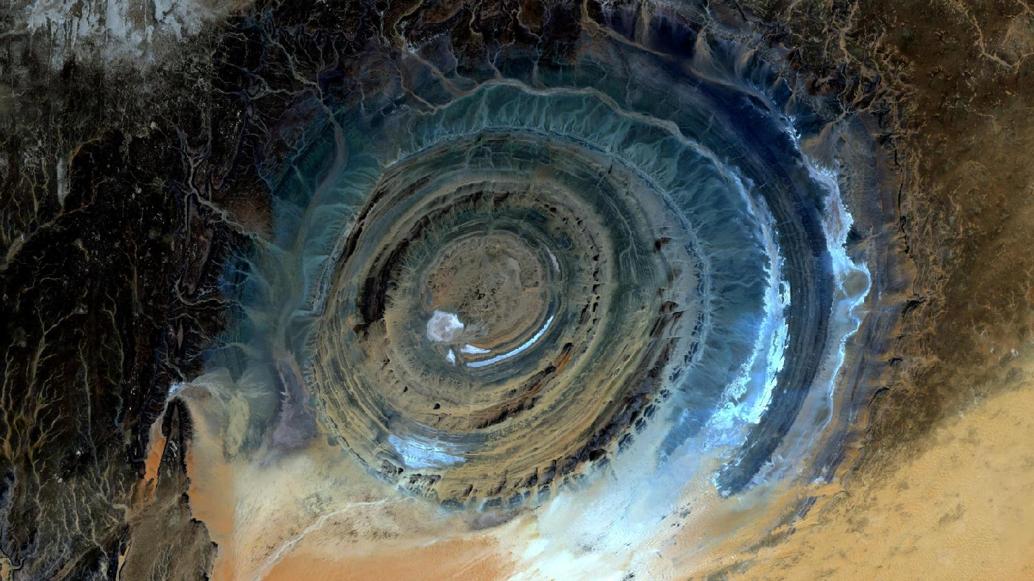
Das Satellitenbild des Monats Juni zeigt ein Echtfarbenbild des “Guelb er Richat” oder auch “Eye of Africa”, aufgenommen in der mauretanischen Sahara in Westafrika. Das Bild wurde aus verschiedenen Bändern, basierend auf Sentinel-2A Daten des EU Copernicus Programms erstellt und bietet eine Auflösung von zehn Metern.
Nach dem Download wurde die Szene mit freier Software atmosphärenkorrigiert und mit drei verschiedenen Bändern eine Farbkomposition berechnet.
Die auffällig ringförmige Struktur des Guelb er Richat befindet sich in der mauretanischen Provinz Adrar und circa 30 km nordöstlich der Stadt Oudane. Die Provinz Adrar ist mit etwa 70.000 Einwohnern eine der am dünnsten besiedelten Regionen in Mauretanien. Sie ist zu einem sehr großen Teil mit Wüste und Bergen bedeckt, daher führt nur eine Schotterpiste von der Stadt Ouadane durch ein karges und menschenleeres Gebiet zum “Eye of Africa”.
Die gesamte geologische Struktur des Guelb er Richat hat einen Durchmesser von etwa 45 Kilometern und besteht aus mehreren Sediment-Gesteinsringen welche nur wenige Meter hoch sind.
Im Inneren der Formation befindet sich ein etwa 20 Meter breiter Gesteinsgang, dieser liegt circa drei km vom Zentrum der Richat Struktur entfernt. Der äußere Gesteinsgang ist ca. 50 m breit und liegt ca. 7 bis 8 km vom Zentrum entfernt. In Summe besteht die Richat Struktur aus 32 Karbonatit-Gräben, welche typischerweise etwa 300 Meter lang und ein bis viert Meter breit sind.
Das Karbonatit Gestein wird auf etwa 95 bis 105 Millionen Jahre geschätzt.
Der Entstehung dieser außergewöhnlichen geologischen Struktur ist nicht unumstritten: Bis vor einiger Zeit ging man von einem Asteroideneinschlag aus, welcher aufgrund der nahezu perfekten Kreisform nahe lag. Inzwischen ist man sich jedoch einig, dass es sich um eine hochsymmetrische und tief erodierte geologische “Kuppe” handelt, welche durch eine Hebung verschiedener Erdschichten entstand. Die Theorie eines Meteoritenkraters konnte nicht bestätigt werden, da es nach Laborauswertungen keinerlei Hinweise auf außerirdische Einwirkungen gab.
Contains modified Copernicus Sentinel data (2016)/ESA – created by mundialis
Weitere Satellitenbilder gibt es unter https://maps.mundialis.de
Die Erde als Kunstwerk: https://art.mundialis.de