
Berlin – Germany, recorded by the Sentinel-2B satellite on September 30, 2022
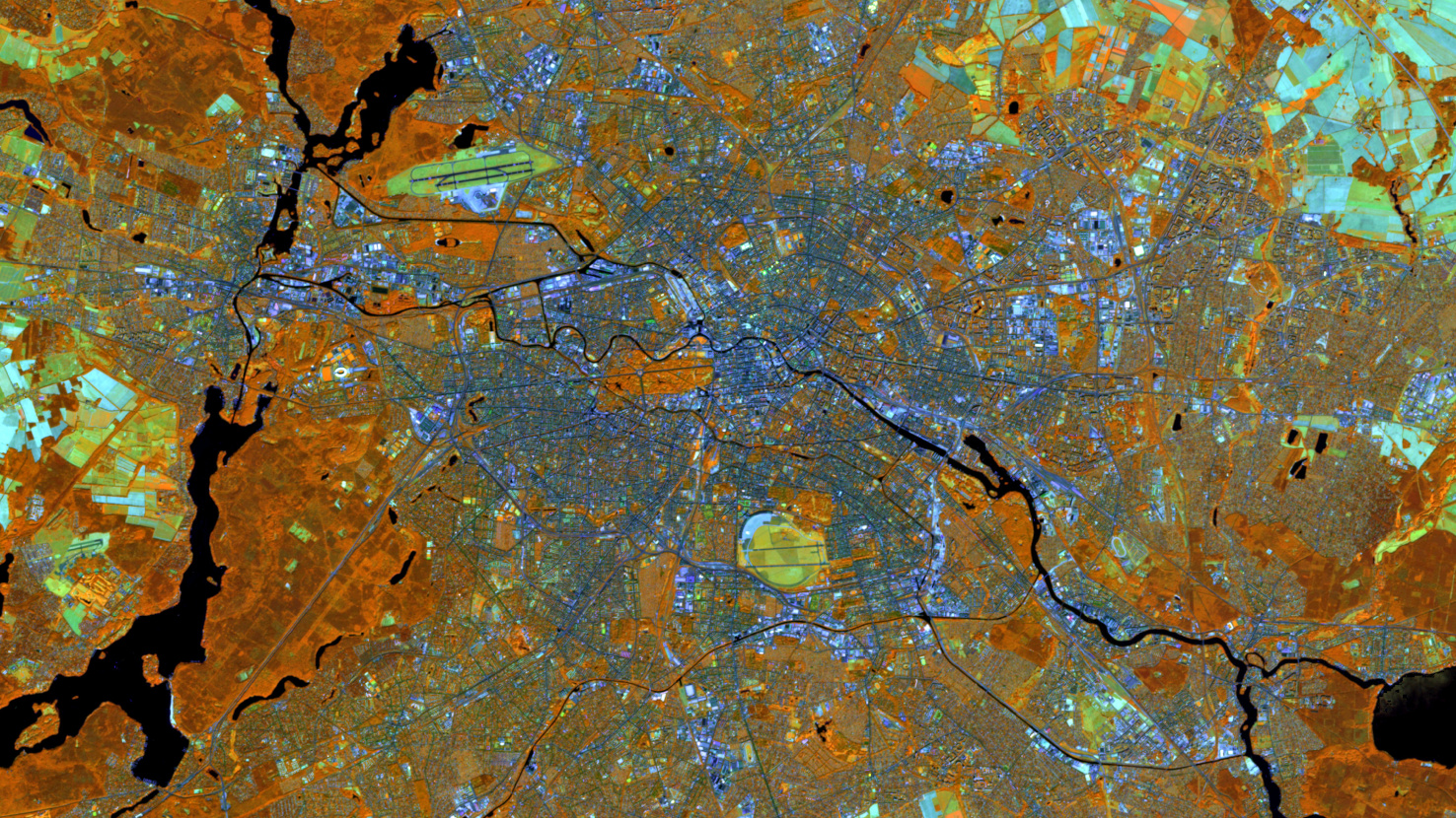
The satellite image of the month March shows the German city of Berlin.
The image is based on freely available multispectral satellite images from the Sentinel-2 satellite of the Copernicus Programme. After downloading the scene an atmospheric correction was carried out using free software. Then a color composite was calculated with three different spectral bands. Bands 8A (visible and near infrared), 11 (shortwave infrared), and 4 (visible red) were used which provide a spatial resolution of 20 meters. This band combination is a false color composite useful for discriminating land and water. Healthy vegetation appears in orange, older vegetation in green. Soil and clouds appear in various shades of green to turquoise, water is shown in dark blue and built-up area is blue-greyish to purple.
Berlin is not only Germany’s capital, but also the country’s largest and most populous city. Approximately 3.7 million inhabitants live in the city covering an area of 892 square kilometers. The entire Berlin agglomeration has approximately 4.7 million inhabitants.
The rivers Spree and Havel, as well as numerous lakes and forests are located in the urban area of the city state of Berlin. The river Spree flows through the city from southeast to west. It enters the picture at the lower right corner and can be easily followed in the central part of the picture by its arc-shaped course. In the west of the city it flows into the rivver Havel, which reaches the city from the north. The river Havel, visible (vertically) in the left third of the image, is much wider than the Spree. Its course in a glacial channel often resembles a lake landscape. The largest bights are Lake Tegel (in the top left of the image) and Großer Wannsee („Greater Wannsee“) (in the bottom left of the image). Adjacent to Lake Tegel lie the forest Tegel to the north and the Jungfernheide (forest) to the south (between the lake and the airport). They are both depicted in dark orange. The large forest area to the northeast of the Wannsee, which is also visible in dark orange, is the Grunewald.
In a similar orange tone, the park Großer Tiergarten can be seen quite centrally in the picture. The Tiergarten is intersected by a few wider streets, such as the 17th of June Street. At the center of their their intersection, the Great Star, stands the Victory Column. The circular intersection can be seen in the left half of the Tiergarten. In the northeast corner of the Tiergarten are located the Reichstag building and the German Chancellery.
Other striking areas in the picture are the Berlin Tegel Airport in the northwest of the city and the Tempelhof Field in the southeast. Both can be recognized by their greenish color, which indicates older vegetation. The Berlin Tegel Airport is rather elongated and runways stand out clearly. The Tempelhof Field has a more rounded shape. Also here, runways can still be recognized. The area of the former Tempelhof Airport is now used as a park and recreation area.
In March, Berlin will host this year’s FOSSGIS conference at the Humboldt University of Berlin. FOSSGIS is the leading conference in the D-A-CH region for Free and Open Source Software for geoinformation systems as well as for the topics of Open Data and OpenStreetMap. mundialis is very pleased that FOSSGIS 2023 can once again be held as an event with physical attendance. As in previous years, mundialis will report on new developments from the company. More about the contributions and workshops can be read here and here. The complete program of FOSSGIS 2023 (German only) can be found here.
Contains modified Copernicus Sentinel data (2022)/ESA – created by mundialis
More satellite images can be found here: https://maps.mundialis.de