
Ulaanbaatar in der Mongolei
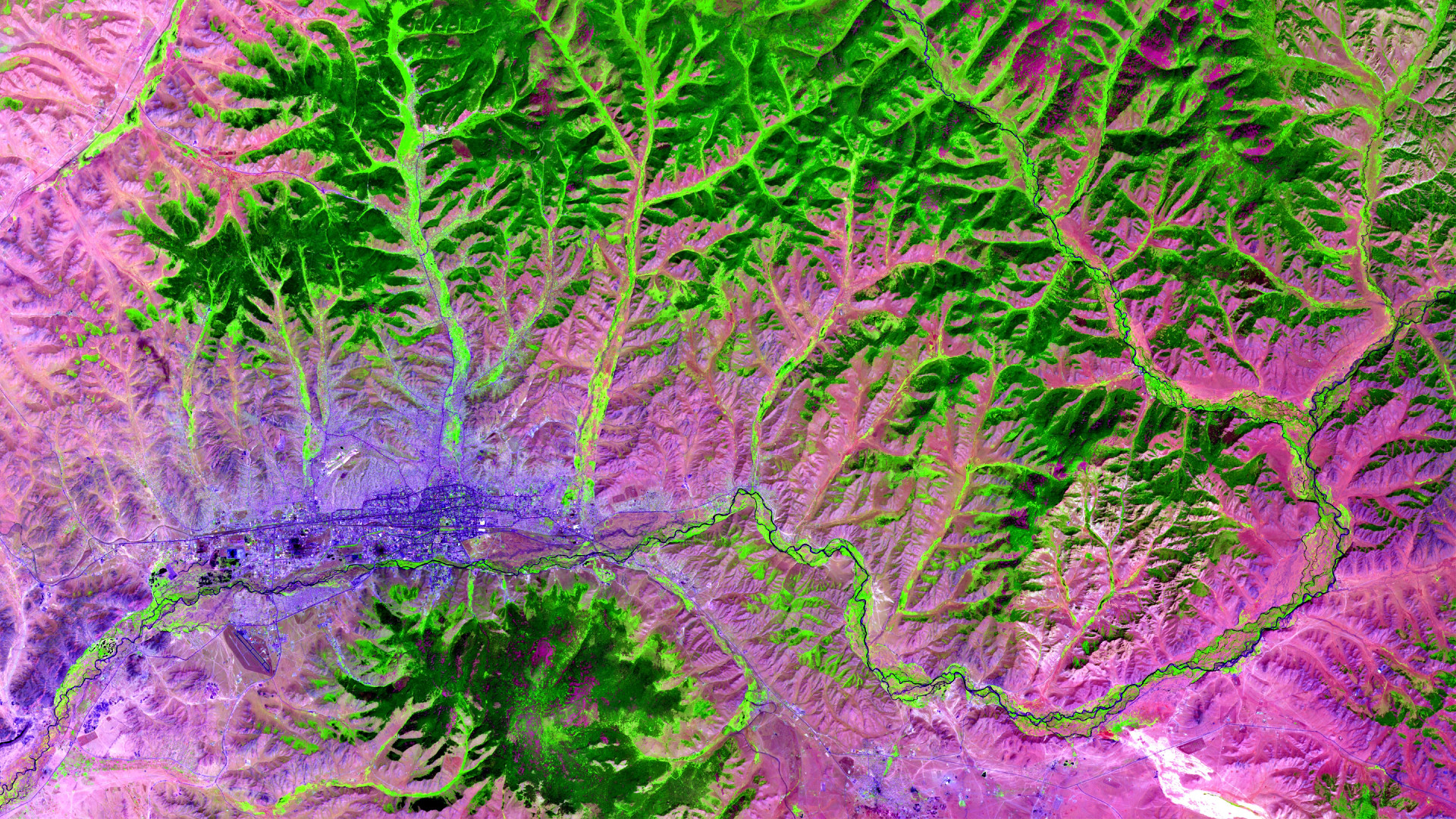
Das Satellitenbild des Monats Oktober zeigt die mongolische Hauptstadt Ulaanbaatar (Ulan-Bator), sowie den angrenzenden Gorchi-Tereldsch-Nationalpark im Nordosten des Landes.
Das dargestellte Bild zeigt eine Vegetationsanalyse der Region und wurde aus verschiedenen Bändern, basierend auf Sentinel-2A Daten des EU Copernicus Programms erstellt, nach dem Download wurde die Szene von uns mit Freier Software bearbeitet.
Ulaanbaatar liegt 1350 Meter über dem Meeresspiegel und ist die größte Stadt der Mongolei mit über 1,3 millionen Einwohnern. Sie ist ebenfalls das politische, wirtschaftliche und kulturelle Zentrum der Mongolei, welche das am dünnsten besiedelte Land der Erde ist (zusammen mit Westsahara). Die Hauptstadt lässt sich auf dem Satellitenbild in der linken Bildhälfte in dunkellila identifizieren, deutlich zu erkennen sind unter anderem ganze linear verlaufende Straßen oder auch der im Süden gelegene internationale Flughafen “Chinggis Khaan”.
Gut zu erkennen ist ebenfalls, dass Ulaanbaatar an dem stark mäandrierenden Fluss “Tuul” liegt, dieser wurde bisher nur wenig von Menschenhand begradigt. Die Umgebung des Flusses ist hauptsächlich von Weiden- und Birkenwäldern geprägt, diese sind anhand der hellgrünen Färbung zu identifizieren.
Aufgrund der wachsenden Bevölkerung, erlebt Ulaanbaatar einen starken Flächendruck insbesondere entlang des Flusses Tuul. Durch neue Gebäude, eine Kläranlage und durch Bergbauaktivitäten, ist der Unterlauf des Flusses stark verschmutzt.
Der Quellursprung des Tuul liegt im nordöstlich gelegenen Gorchi-Tereldsch-Nationalpark, welcher sich auf dem Satellitenbild durch eine gebirgige Struktur erkennen lässt.
Der Gorchi-Tereldsch-Nationalpark liegt nur etwa eine Autostunde entfernt von der Hauptstadt Ulaanbaatar und ist daher ein beliebtes Ausflugsziel für Touristen. Er bietet Möglichkeiten für Wanderungen und Rafting, zum Bergsteigen, Schwimmen (in eiskaltem Wasser), Reiten und – für Extremsportler – Skifahren im tiefen Winter. Der Nationalpark diente insbesondere aufgrund seiner einzigartigen Steinformationen bereits oft als Kulisse für mongolische Filme.
Contains modified Copernicus Sentinel data (2016)/ESA – created by mundialis
Weitere Satellitenbilder gibt es unter https://maps.mundialis.de
Die Erde als Kunstwerk: https://art.mundialis.de