
Sundarbans in Bangladesch
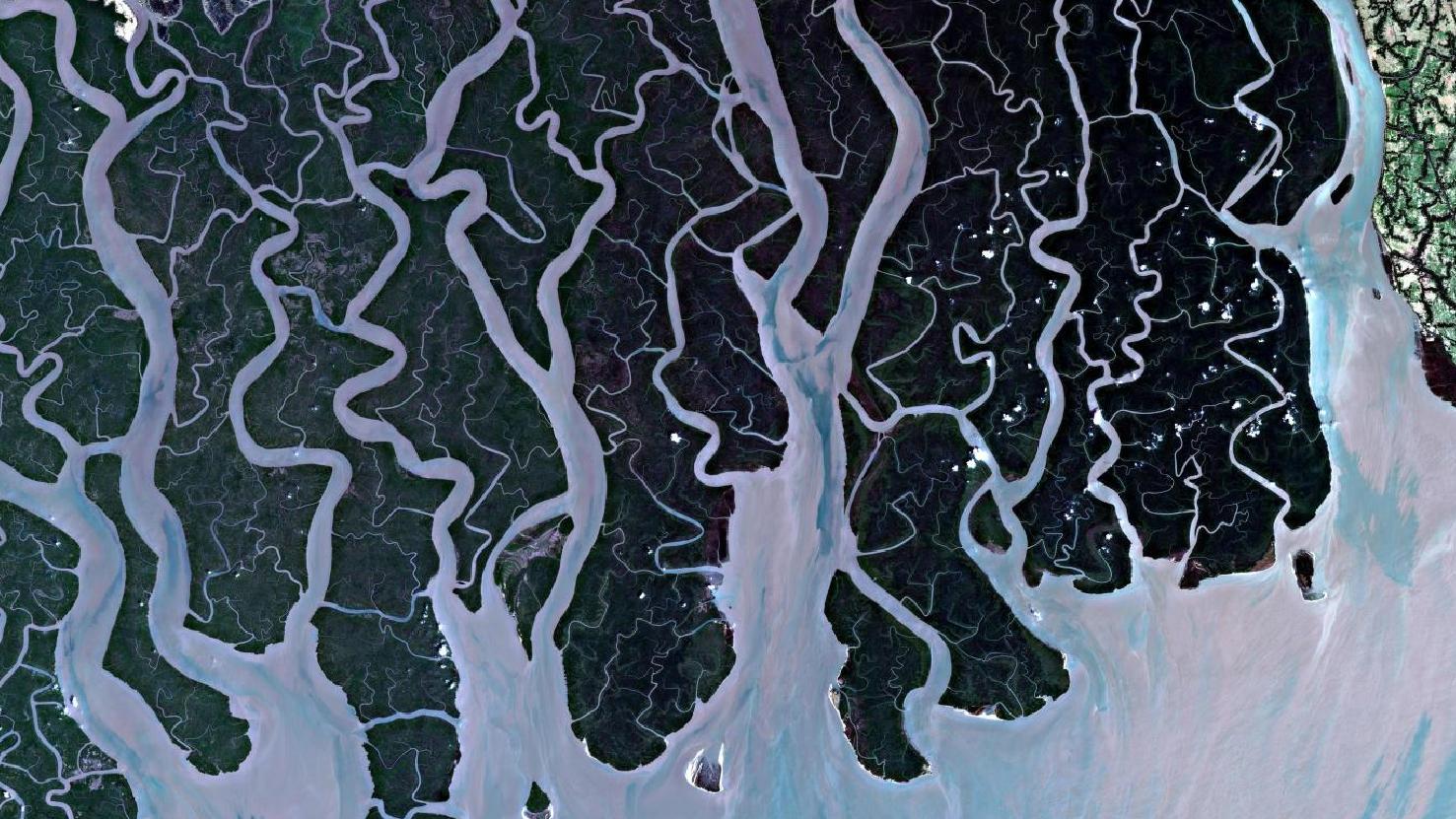
Das Satellitenbild des Monats September zeigt die sogenannten Sundarbans, es handelt sich dabei um die am Golf von Bengalen gelegenen größten Mangrovenwälder der Erde. Der größere Teil des Bildes zeigt dabei Bangladesch, ein kleinerer westlicher Teil liegt auf indischen Gebiet.
Das dargestellte Echtfarbenbild wurde aus verschiedenen Bändern, basierend auf Sentinel-2A Daten des EU Copernicus Programms erstellt, nach dem Download wurde die Szene von uns mit Freier Software bearbeitet.
Die Sundarbans umfassen insgesamt eine Fläche von etwa 10.000 km², davon entfallen ca. 2/5 auf Indien und 3/5 der Fläche auf Bangladesch und beherbergen neben einzigartiger Flora und Fauna auf dem Festland und auf den über 200 Inseln, auch etwa 13 Millionen Menschen.
Die Bevölkerung teilt sich das Gebiet unter anderem mit dem vom Aussterben bedrohten bengalischen Tiger, Salzwasserkrokodilen oder auch dem ebenfalls bedrohten Axishirsch. Etwa 25% des gesamten Gebietes sind heute geschützt, dabei wurde der indische Sundarbans Nationalpark von der UNESCO 1987 zum Weltnaturerbe erklärt.
Deutlich zu erkennen sind die zahlreichen Flussarme, die das gesamte Gebiet der Mangrovenwälder durchziehen und schließlich im Golf von Bengalen im indischen Ozean münden. Dabei wird das Gebiet von drei Hauptflüssen bewässert, dies sind von West nach Ost der Ganges, der Brahmaputra und ganz im Osten der Meghna.
Alle drei Flüsse teilen sich im Gebiet der Sundarbans in mehrere Flussarme auf und bilden so das verzweigte Flusssystem. In rosa-grauen Farbtönen sind die von den Flüssen im Meer abgelagerten Sedimente gut zu erkennen.
Aufgrund des jährlichen Monsuns und der Wassermassen aus dem Himalaya, sind insbesondere die tief gelegenen südlichen Sundarbans von Überschwemmungen bedroht, diese Bedrohung der dort lebenden Menschen und Tiere wird verstärkt durch den klimabedingten Anstieg des Meeresspiegels.
Die Bewohner versuchen daher insbesondere von den südlichen Sundarbans weiter in den Norden zu flüchten, wo die Flussarme noch nicht allzu breit und somit gefährdet sind über die Ufer zu treten, wie im Süden.
Am östlichen Rand des Satellitenbildes lässt sich eine kleine Ecke abgrenzender Vegetation erkennen: Diese unterscheidet sich deutlich von den für die Sundarbands typischen Mangrovenwäldern, welche die charakteristische dunkelgrüne Färbung verursachen, und teilt optisch die Sundarbands markant vom umliegenden Land ab.
Was auf dem Satellitenbild nicht zu erkennen ist, ist die Wandlungsfähigkeit der Mangroveninseln und Flussarme in den Sundarbans. Durch Überschwemmungen, Meeresströmungen und tektonische Besonderheiten verschwinden einzelne Inseln immer wieder gänzlich, während an anderer Stelle neue entstehen oder ehemalig versunkene wieder auftauchen
Contains modified Copernicus Sentinel data (2016)/ESA – created by mundialis
Weitere Satellitenbilder gibt es unter https://maps.mundialis.de
Die Erde als Kunstwerk: https://art.mundialis.de