
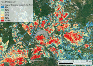
Flood events cause enormous damages and losses which are only poorly documented in many areas of the world. Because of this, the Sendai framework for disaster risk reduction aims to establish a set of standardized indicators to represent the impact of natural disasters on a yearly basis. The VALE project (Development and VALidation of earth observation-based indicators for the monitoring of the Sendai framework using the example of flooding in Ecuador; funded by BMWI, grant reference: 50EE1920B) explores the potential of remote sensing data for the calculation of Sendai indicators, focusing on flood statistics in Ecuador.
For this purpose, mundialis developed a methodology for flood extraction and temporal aggregation from Sentinel-1 data. Due to their specular surface, water bodies reflect the satellite’s signal away from the sensor, resulting in characteristically dark areas in Sentinel-1 scenes. A combination of image segmentation and automatic thresholding is applied to identify flooded areas. A reference dataset is used to distinguish them from permanent water bodies. After analyzing all Sentinel-1 scenes of one year, a temporally aggregated flood hazard map can be derived. It can be combined with further reference data such as local population, land use, etc. to form the basis for Sendai indicator calculation.
This procedure can be automatically applied to any area and time of interest – the long-term orientation of the Copernicus program guarantees the ongoing acquisition of Sentinel-1 data.Flood events cause enormous damages and losses which are only poorly documented in many areas of the world. Because of this, the Sendai framework for disaster risk reduction aims to establish a set of standardized indicators to represent the impact of natural disasters on a yearly basis. The VALE project (Development and VALidation of earth observation-based indicators for the monitoring of the Sendai framework using the example of flooding in Ecuador) explores the potential of remote sensing data for the calculation of Sendai indicators, focusing on flood statistics in Ecuador.
For this purpose, mundialis developed a methodology for flood extraction and temporal aggregation from Sentinel-1 data. Due to their specular surface, water bodies reflect the satellite’s signal away from the sensor, resulting in characteristically dark areas in Sentinel-1 scenes. A combination of image segmentation and automatic thresholding is applied to identify flooded areas. A reference dataset is used to distinguish them from permanent water bodies.
After analyzing all Sentinel-1 scenes of one year, a temporally aggregated flood hazard map can be derived. It can be combined with further reference data such as local population, land use, etc. to form the basis for Sendai indicator calculation.
This procedure can be automatically applied to any area and time of interest – the long-term orientation of the Copernicus program guarantees the ongoing acquisition of Sentinel-1 data.
[espro-slider id=4188]