Menu
  • About us
    • Company
    • Team
    • Career
    • References
    • Partners
    • Contact
  • Products
    • Earth Observation metadata enhancer
    • Temperaturdaten
    • LST-Data Client
    • Trainings
  • Services
    • actinia – geoprocessing in the cloud
    • Geospatial and EO data analysis
    • CORONA spy satellite data
    • maps.mundialis
    • Web Map Services
    • GIS Development
    • Open Source GIS
  • Markets
    • Remote Sensing for Agriculture
    • Satellite Images for Forest and Land Cover Restoration
    • Glass fibre route planning – FTTH
    • Copernicus and Sentinel
  • News & Blog
    • News
    • Blog
    • Satellite image of the month
  • English English
  • Deutsch Deutsch

Meet us at FOSS4G 2019 in Bucharest, Romania!


24. August 2019 | Category General

We are on our way to Bucharest, to the FOSS4G 2019 conference of OSGeo.

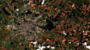
Bucharest seen by Sentinel-2 satellite

Bucharest as seen by Sentinel-2 satellite

We will be offering

… two workshops (as supporters of the workshop leaders):

  • Object-based image analysis (OBIA) with GRASS
  • Spatio-temporal data processing and visualization with GRASS GIS


… and three presentations:

  • GRASS GIS in the cloud: actinia geoprocessing (talk | video)
  • How digging in the earth for the fibre roll-out took GRASS to the cloud (talk | video)
  • State of GRASS GIS Project: 35 years is nothing! (talk | video)


For the schedule, please visit our overview page at

https://mundialis.github.io/foss4g2019/

In addition, we will be present at the booth of our sister company terrestris.

See you in Bucharest!

Comments are currently closed.

Follow Us

Contact

mundialis GmbH & Co. KG
Kölnstrasse 99
53111 Bonn

Phone: +49 (0)228 / 387 580 80
Fax: +49 (0)228 / 962 899 57

E-Mail: info [at] mundialis [dot] de

Latest News

  • FOSSGIS 2023 – this time in Berlin again!

    Tuesday February 21st, 2023
  • ++ Eine neue Heimat für Actinia ++

    Tuesday January 24th, 2023
  • Positive towards the future – Management changes at mundialis

    Tuesday October 4th, 2022
  • Recap of FOSS4G 2022 in Florence

    Friday September 16th, 2022
  • FOSS4G 2022 in “La Bella” – Greetings from Florence!

    Thursday July 14th, 2022
View all News

Blog

  • Satellite image of the month – March – Berlin (Germany) 7. March 2023
    Berlin – Germany, recorded by the Sentinel-2B satellite on September ...
  • Satellite image of the month – February – Amazon Rainforest (Brazil and Bolivia) 7. February 2023
    Amazon Rainforest – Brazil and Bolivia, recorded by the Sentinel-2A ...
  • Satellite image of the month – January – Yalu River (People’s Republic of China and Democratic People’s Republic of Korea) 2. January 2023
    Yalu River – People’s Republic of China and Democratic People’s ...
View all Blog Posts

Copyright © 2015-2023 mundialis GmbH & Co. KG

Imprint Privacy

Theme created by PWT. Powered by WordPress.org