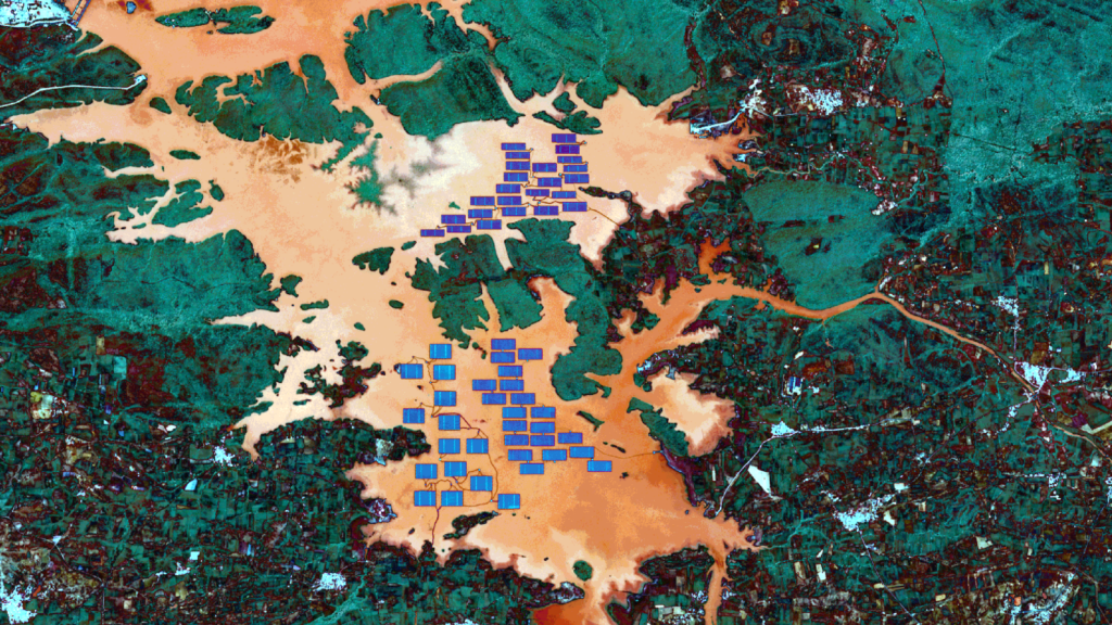
October’s Satellite Image of the Month is the tenth part of our visual journey and turns our attention to southern Asia. This month, we look at the Omkareshwar floating solar park in Khandwa district (India), the largest project of its kind in the country. With a targeted energy output of 600 megawatts, the solar park will make an important contribution to the expansion of renewable energy in India.
The image shows the reservoir of the Omkareshwar Dam, which impounds the Narmada River, captured by the European Copernicus satellite Sentinel-2A. The combination of near infrared (band 8), visible red light (band 04) and visible green light (band 03) makes vegetation, sealed surfaces and water bodies stand out. Further processing allows the solar modules to be highlighted.
You can find detailed information on how we process satellite images and on the “Atmospheric Penetration” composite we use here.
Structure of the Image
At the centre of the image, the solar modules of the Omkareshwar solar park stand out in indigo blue. The module arrays cover areas many times the size of a football pitch. Rust-brown areas show the deeper parts of the reservoir, while lighter areas indicate shallow water. This is particularly clear along the adjoining shoreline.
On land, wooded areas, shown here in petrol blue, can be distinguished from grass-covered areas in burgundy. Fallow fields range around a chestnut brown. Built-up areas such as towns and cities stand out from their surroundings in cyan, as can be seen, for example, in the town of Indhawadi in the upper right of the image.
A Solar Park That Floats
Floating solar plants are built on bodies of water such as reservoirs and therefore require no additional land. The water can cool the modules, and the covered water surface can reduce evaporation. At the same time, wind, fluctuating water levels and anchoring place particular demands on planning and operation. How sensitive such plants are to weather events became clear on 9 April 2024, when a storm with wind speeds of around 50 km/h damaged part of the plant at Omkareshwar.
The park is part of a larger development. India is seeing strong growth in the renewable energy sector and, as early as mid-2025, generated over 50% of its electricity from renewable sources. Solar and wind power account for the lion’s share, at 185 gigawatts. In 2025, the Omkareshwar solar park had an installed capacity of 278 megawatts. This development is linked to India’s steady economic growth and the resulting rise in energy demand. The expansion is driven not only by the government but, to a large extent, by private companies taking advantage of favourable policy conditions.
However, India’s largest solar parks do not float but are located on land, for example the Bhadla Solar Park in Rajasthan with a capacity of 2,245 megawatts or the Pavagada Solar Park in Karnataka, which covers an area of 53 km².
Monitoring plants of this size efficiently and making initial damage assessments after events such as the 2024 storm requires reliable, area-wide data. Private and public-sector organisations alike depend on it.
Estimating Solar Potential
At mundialis, we use remote sensing data and our own software solutions to record solar potential across entire areas in an automated way. To do so, we extract, analyse and evaluate specific parameters as a basis for decision-making in a wide range of applications. Would you like to plan solar potential digitally? Get in touch with us.