

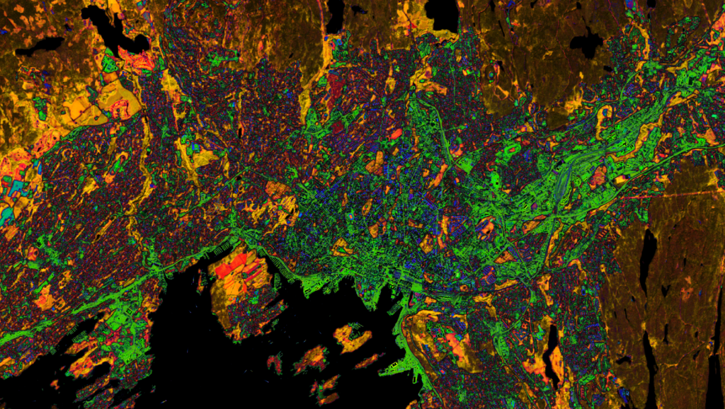
The Satellite Image of the Month for September is the ninth part of our twelve-part visual journey, turning our gaze to northern Europe. This month we look at Oslo, which was named European Green Capital in 2019 and stands out across Europe for its green infrastructure. Alongside a largely car-free city centre, the city offers a wealth of green recreational areas in the form of parks and green spaces.
The image shows Oslo’s urban area and the adjoining forest belt “Marka”, captured by the European Copernicus satellite Sentinel-2C. Combining short-wave infrared (band 11), narrow near-infrared (band 8A) and visible red light (band 04) makes vegetation, sealed surfaces and water bodies clearly distinguishable from one another.
Detailed information on our satellite image processing and the “atmospheric penetration” composite used can be found here.
Structure of the image
Rendered in a dark brown tone, the forested ridge “Marka” encircles Oslo like a ring. To the northwest lie agricultural areas in amber, which are still green at the time of recording and therefore appear colour-wise close to the forested areas. This is particularly evident along the Lysakerelva river in the west: its sun-yellow riverside vegetation marks the city boundary with the neighbouring municipalities before the river flows into the black-appearing Lysaker Fjord.
The suburban city area shows a broad colour spectrum ranging from crimson red to midnight blue and indigo violet – a sign that the built environment does not overlay the natural landscape but integrates into it. The midnight-blue patches within it are houses with brick-red roofs, as is the central station in the city centre. Grass-green highlighted areas, by contrast, are not vegetation but light grey infrastructure such as roads, for example in the northern district of Alna.
A green city in the north
DasThe figures also show just how green Oslo is: more than two-thirds of the municipal area consists of protected forest, water bodies and agricultural land – above all the Marka, which encircles the city like a green ring. 95 per cent of residents can reach a green space within 300 metres, often via connected footpaths. The best-known green spaces include the Slottsparken around the Royal Palace, the Botanical Garden in Tøyen, and the Medieval Park in the historic city centre.
Beyond classic parks, too, Oslo has green space firmly in mind: as part of the “Bilfritt Byliv” programme, numerous inner-city parking spaces have been converted into cycle paths, seating areas and small green spaces. To measure and expand on this progress, however, cities need more than a view of individual projects – they need reliable, area-wide data on how their green cover develops over time.
Capturing urban green spaces
At mundialis, we use remote sensing data to capture urban green spaces comprehensively and automatically: we extract, analyse and evaluate specific parameters for a wide range of applications. Combined with the short revisit times of satellite imagery such as Sentinel-2, this makes it possible to detect changes in urban green cover at an early stage.
The result: a solid data foundation for sustainable urban development and tailored solutions – from basic inventory capture through to assessing the health effects of green spaces on the population.
Learn more:
Our product for capturing urban green spaces
Reference project: Effects of urban green spaces on human health
Recording of our webinar: Single tree detection
You can also find satellite images for your wall at Art from Space and ama walls.