
Betsibokadelta in Madagaskar
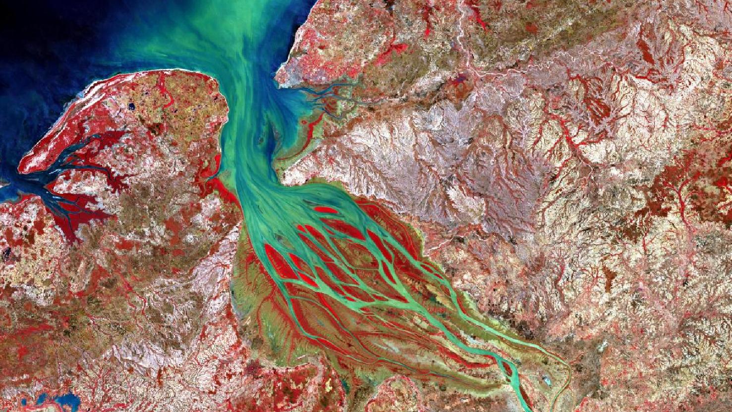
Das Satellitenbild des Monats Januar zeigt eine Falschfarben Komposition der Mündung des Betsiboka Flusses im Norden Madagaskars. Das Bild wurde aus verschiedenen Bändern, basierend auf Sentinel-2A Daten des EU Copernicus Programms, erstellt. Die verwendete Infrarotkombination ist nützlich um eine Vegetationsanalyse durchzuführen und bietet eine Auflösung von 10 Metern.
Die grünen Verfärbungen in der Flussmündung des Betsiboka deuten auf eine starke Sedimentierung und Mineralienablagerung hin. Rote Flächen im Landesinneren markieren grundsätzlich Vegetation, besonders intensive Rotfärbungen deuten auf Pflanzenarten mit besonders viel Cholorophylgehalt hin, wie beispielsweise im Flussdelta.
Der Betsiboka ist 525 Kilometer lang und entspringt bei etwa 1600 Metern Höhe. Der Beiname “Roter Fluss” lässt sich durch die starke Sedimentierung, besonders in der Flussmündung, erklären. Während der starken Regenfälle in der Regenzeit sammeln sich besonders viele Mineralien und rötlicher Mutterboden im Flussdelta, und machen den Betsiboka auch außerhalb der Regenzeit im Flussmündungsgebiet unbefahrbar für größere Schiffe. Das gesamte Flussgebiet auf dem Satellitenbild ist somit nur für kleinere Boote befahrbar. Diese starke Sedimentierung ist ein Resultat der nach wie vor praktizierten Brandrodung in weiten Teilen der Region.
Vergleicht man die Flussmündung des Betsiboka mit der eines Flussbettes welches auf dem Satellitenbild weiter im Westen liegt, so erkennt man schnell, dass hier eine geringere oder sogar gar keine Sedimentierung stattfindet.
Das Flusswasser des Betsiboka wird im besonders durch Landwirtschaft geprägten nördlichen Madagskar für den Anbau von Reisflächen benötigt. Die weit überschwemmten Gebiete, welche auch auf dem Satellitenbild gut zu erkennen sind, eignen sich hierfür besonders gut. Der Anbau von Obst- oder Gemüsesorten ist hier jedoch nicht mehr möglich, aufgrund der massiven Brandrodungen, die die ursprünglichen Waldgebiete in eine Savanne verwandelt haben.
Contains modified Copernicus Sentinel data (2017-2018)/ESA – created by mundialis
Weitere Satellitenbilder gibt es unter https://maps.mundialis.de
Die Erde als Kunstwerk: https://art.mundialis.de