
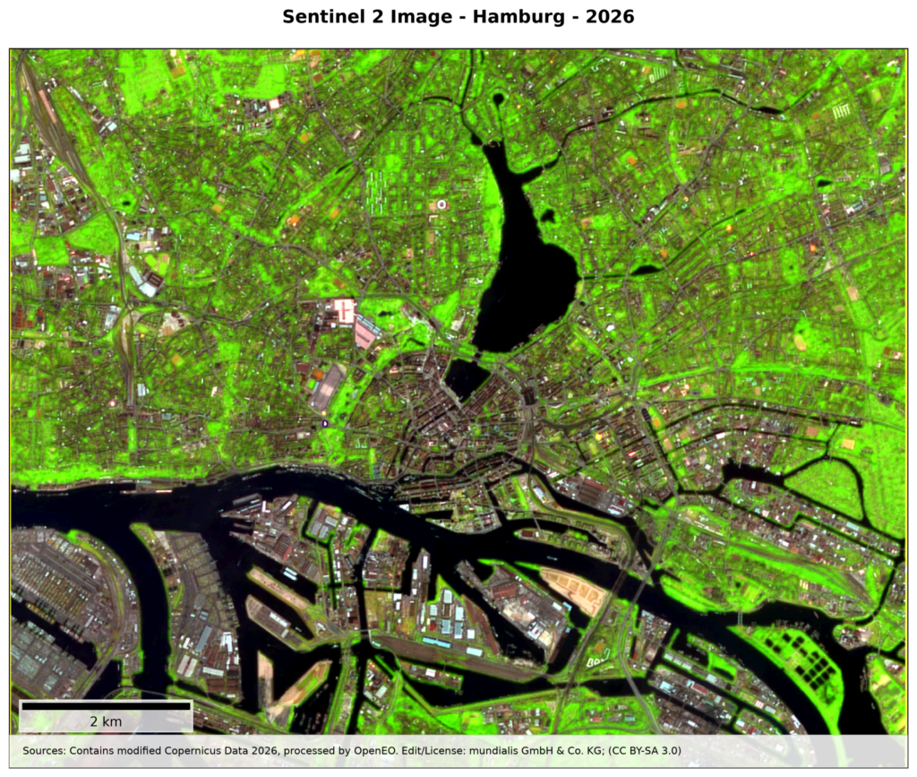
The Satellite Image of the Month for August is the eighth part of our visual journey and takes us further into the theme of analysing urban spaces. This month we turn our attention to Hamburg, which was awarded the “European City of Trees”-Award in 2025.
The image shows the northern harbour facilities and the city centre of the Hanseatic city of Hamburg, captured by the European Copernicus satellite Sentinel-2. By combining short-wave infrared (SWIR), narrow near-infrared (Narrow NIR) and red light, healthy vegetation appears in bright green tones. Sealed surfaces and buildings, by contrast, stand out in magenta, brown and grey, while waterways appear in dark blue to black.
Image Composition
At the center of the image, the Inner and Outer Alster lakes and the winding course of the Norderelbe shape the cityscape. Thanks to the infrared false-color rendering, Hamburg’s green network becomes immediately apparent: extensive green spaces such as the historic ramparts and the Planten un Blomen park directly west of the Inner Alster, the Altona parklands at the western edge of the image, and Hammer Park in the east stand out as bright green islands amid the densely built urban fabric.
At the same time, green corridors extend along the branches of the Alster, the canals, and the dense street network, weaving through the city’s neighborhoods. This vividly highlights Hamburg’s rich tree cover and tree-lined streets, underscoring the abundance of urban greenery that has earned the city the title of “European City of Trees.”
This pronounced greenery stands in sharp contrast to the historically dense city centre and the largely sealed logistics and industrial areas of the harbour in the southern part of the image, where the dark, finely structured harbour basins and docks reveal the close interplay of water, logistics and urban structure.
Hamburg’s Urban Trees in a Changing Climate
As “European City of Trees 2025”, Hamburg has taken on a pioneering role in protecting and maintaining its tree population. Targeted tree protection at construction sites, monitoring of tree diseases, and forward-looking management of older trees, in particular, have helped the Hanseatic city stand out among its competitors.
However, climate change — with increasing droughts, intense heat islands and growing pest infestation — is putting considerable strain on urban trees. To effectively protect and manage urban forests and street trees, a look at the overall tree population alone is not enough — municipalities need precise information on the condition of each individual tree. Where are particularly vulnerable older trees located? Where are canopy gaps? And how is the vitality of the tree population developing over time?
Detecting Individual Trees from the Air
At mundialis, we use remote sensing and AI for individual tree detection: based on high-resolution aerial imagery we detect and locate trees comprehensively and automatically, and analyse parameters such as crown diameter and vitality.
The result: a data foundation for efficient tree cadastre management, early detection of vitality loss, and targeted urban planning for climate-resilient green infrastructure.
Learn more:
Our product for individual tree detection
Case studies & references on individual tree detection
Insights into forest and tree mapping at mundialis
Recording of our webinar: Individual Tree Detection (German)
You can also find satellite images for your wall at Art from Space and ama walls.