
The orthophoto was acquired on August 11, 2025.
The Satellite Image of the Month for June is the sixth part of our twelve-part visual journey. It concludes the thematic section “Traces of Time – Landscapes and Cities in Transition” and introduces the next section, which will focus on urban spaces.
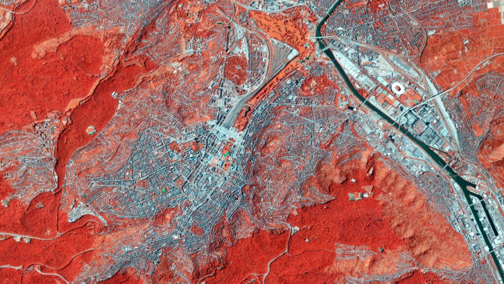
The image shows a section of Stuttgart, the capital of the German state of Baden-Württemberg. This time, however, it is not a satellite image—the underlying data comes from a high-resolution aerial photograph collected during the annual aerial surveys conducted by the state of Baden-Württemberg. The false-color representation is based on the red, green, blue, and infrared bands, from which the color infrared image (CIR) is derived.
Image Composition
At the center of the image lies downtown Stuttgart. Thanks to the false-color rendering, vegetation, which appears in shades of red, can be clearly distinguished from the gray surfaces of concrete and asphalt. Particularly striking is the city’s characteristic topography: steep slopes surround the city center to the north, south, and west, while dense forests cover the elevated plateaus, visible in vivid red.
At the center of the image, Stuttgart Central Station and the major construction project Stuttgart 21 can be seen. At the southern end of the railway tracks, the distinctive construction domes appear as light blue-gray spots, while the pedestrian tunnel running through the construction site is visible as a white line. Also noticeable are the football stadium and the surrounding sports facilities in the upper-right portion of the image, northeast of the Neckar River.
Urban Overheating and Surface Sealing
Since the 1960s, the number of exceptionally hot days in Germany has steadily increased. Cities are particularly affected: where vegetation and open soil are absent, natural shading and cooling through evaporation are lost. Concrete and asphalt store thermal energy during the day and release it as heat after sunset.
In Stuttgart, the city’s basin-like topography significantly intensifies this effect. During summer high-pressure weather conditions, a dome of hot air settles over the city, creating an urban heat island. While the surrounding countryside cools rapidly in the evening, sealed surfaces continue to radiate heat, and the surrounding hills restrict the exchange of cooler air. During prolonged heat waves, heat and pollutants accumulate from day to day, posing a considerable health risk.
This transformation can be clearly illustrated by the example of Stuttgart 21: the lowering of the main railway station and the associated redevelopment of extensive railway areas constitute one of Germany’s largest inner-city transformation projects. How these newly created spaces are used in the future will play a decisive role in determining whether the project helps relieve the city’s climate burden or further exacerbates heat stress in the Stuttgart basin.
Analysis by mundialis
Based on high-resolution aerial imagery (DOPs), mundialis offers products that support data-driven decision-making in urban planning. A key focus is the automated, comprehensive mapping of impervious surfaces within cities. By classifying different surface types—from transportation infrastructure to green roofs and urban vegetation—it becomes possible to precisely quantify sealing levels and assess their impacts on the microclimate and heavy-rainfall risks.
You can learn more through our products for urban impervious-surface analysis and our reference on surface classification. We also recommend our webinars on AI-supported impervious-surface analysis and heat-stress mapping.
LGL-BW (2026) – Datenlizenz Deutschland – Namensnennung – Version 2.0, www.lgl-bw.de
Satellite images for your wall are available at Art from Space and ama walls.