
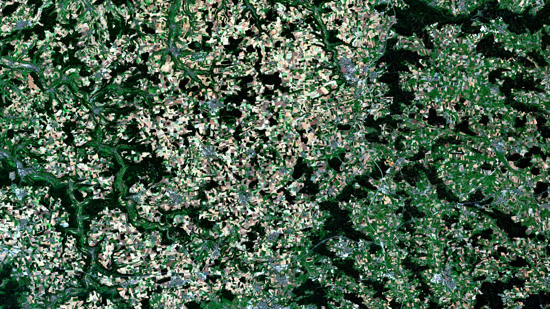
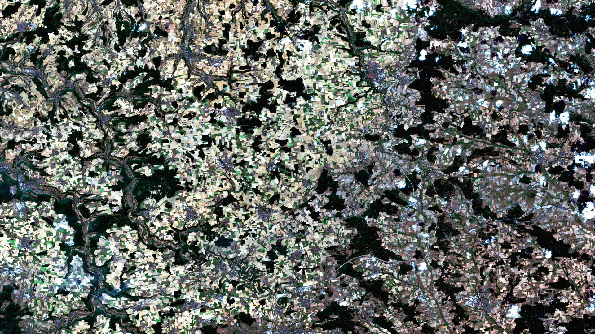
Franconia – Germany, recorded by the Sentinel-2A and -2B satellites on August 14, 2021 and August 14, 2022
The satellite image of the month for May is the fifth image in our twelve-part visual journey.
It continues the series ‘Traces of Time – Landscapes and Cities in Transition’, in which we show satellite images to highlight rather slow changes to the Earth’s surface.
The image shows a section of the region Franconia in central Germany, on the northern border between Baden-Württemberg and Bavaria. The data for the two images comes from the Sentinel-2A and -2B satellites. The image is displayed in true colour based on bands 4 (red), 3 (green) and 2 (blue). Detailed information on image processing and the Sentinel-2 dataset can be found here.
Image Composition
The image shows a highly diverse land cover composite. Dark green areas indicate extensive forest cover, whilst agricultural land appears in light green, yellowish and brown tones – depending on vegetation and cultivation status. Urban areas are characterised by grey to whitish structures, including Rothenburg ob der Tauber (centre to top right) and Crailsheim (centre at the bottom of the image). In the left-hand part of the image, the rivers Kocher and Jagst meander from top to bottom as fine, dark lines through the landscape. In addition, two motorways cut across the scene as white-greyish, linear bands: the A7 runs vertically on the right-hand side, the A6 horizontally in the lower part of the image; their junction is clearly visible in the lower right-hand quadrant.
The 2022 Drought
In 2022, Germany experienced an exceptional drought that hit Baden-Württemberg and Bavaria particularly hard, leading, among other things, to an increased risk of forest fires, groundwater shortages and crop losses. Although individual years cannot be attributed to climate change in isolation, the frequency and intensity of such extreme events are on the rise.
A comparison with 2021, a year with comparatively high rainfall, makes the effects clearly visible: whilst agricultural land in 2021 appears predominantly in rich shades of green, in 2022 large areas are dominated by beige, white and light brown colours – an indication of parched soil and withered vegetation. This difference is particularly striking along the rivers and on the right-hand side of the image. The forested areas also appear less vibrant overall and show brownish edges in places.
Analyzing using Satellite Data
A comparison of the two images clearly demonstrates how clear changes in land cover and land use can be seen from space. At mundialis, we therefore focus specifically on the analysis of satellite data – such as that from Sentinel-2 missions – and on the land use and land cover classifications derived from it. They form the basis for automated analysis, monitoring and change detection – as, for example, in our projects on ecosystem restoration (HERMOSA) or the monitoring of sustainability standards – even in extensive, hard-to-reach areas.
Contains modified Copernicus Sentinel data (2021/2022)/ESA – created by mundialis
Satellite images for your wall are available at https://art-from-space.de